
 Français
 Italiano
Originaldatei (3.700 × 4.687 Pixel, Dateigröße: 7,7 MB, MIME-Typ: image/jpeg)
Beschreibung
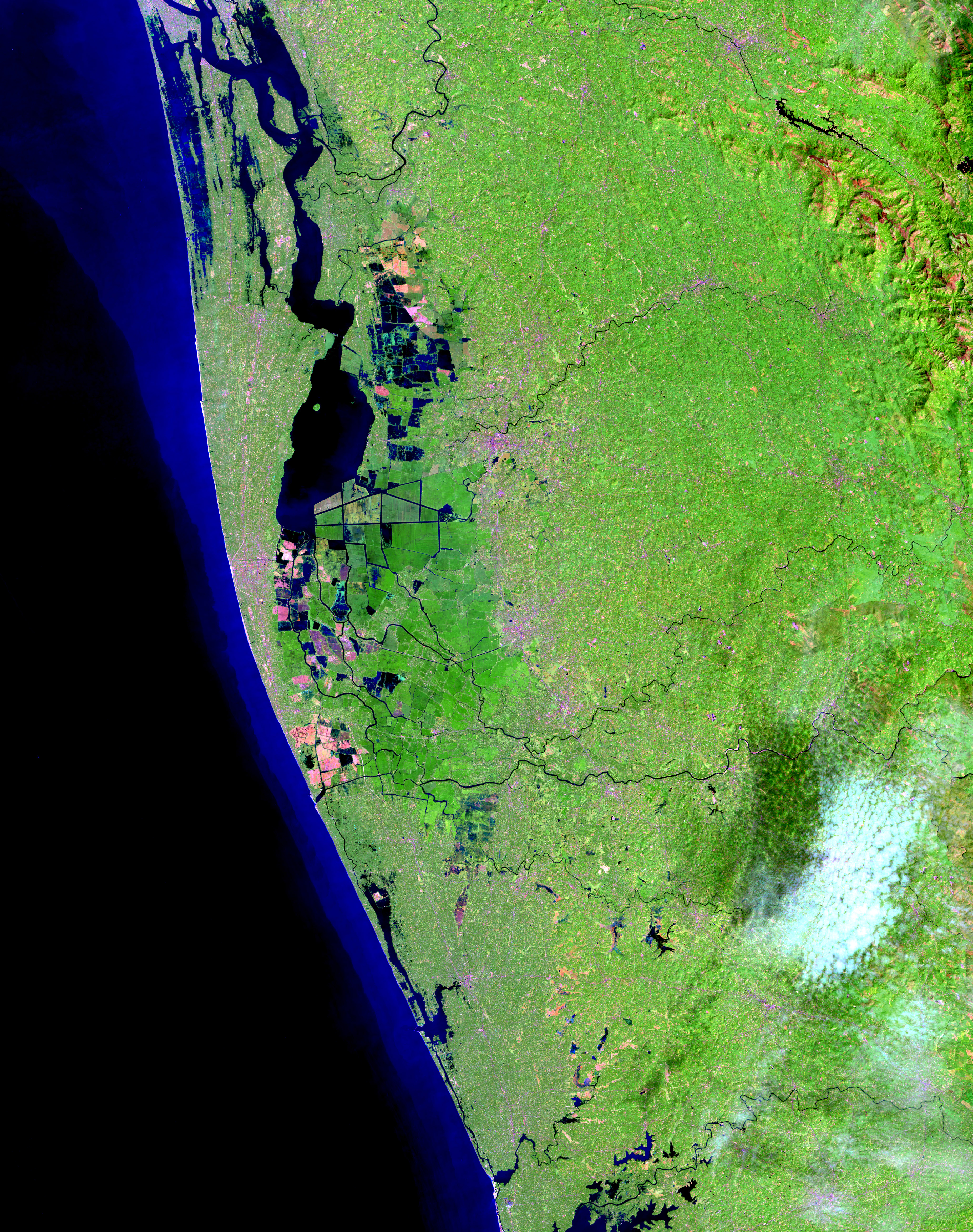
| Beschreibung | English: Residents in India’s state of Kerala are reeling from a "once-in-a-century" flood that displaced nearly a million people, caused hundreds of fatalities, and washed away homes. The region started receiving heavy rain on August 8, 2018, but news reports state that the flooding was worsened by releases from dams. The Operational Land Imager (OLI) on the Landsat 8 satellite acquired the left image (bands 6-5-3) on February 6, 2018, before the flood. The Multispectral Instrument on the European Space Agency’s Sentinel-2 satellite acquired the right image (bands 11-8-3) on August 22, 2018, after flood water had inundated the area. The images are false-color, which makes flood water appear dark blue. Vegetation is bright green. Several rivers throughout the region spilled over their banks. Water from the Karuvannur River ran through 40 villages, and washed away a 2.2 kilometer (1.4 mile) stretch of land connecting two national highways. Elevated water levels along the Periyar River displaced thousands of people. NASA Earth Observatory images by Lauren Dauphin, using modified Copernicus Sentinel data (2018) processed by the European Space Agency and Landsat data from the U.S. Geological Survey. |
| Datum | |
| Quelle | https://earthobservatory.nasa.gov/images/92669/before-and-after-the-kerala-floods, [File https://eoimages.gsfc.nasa.gov/images/imagerecords/92000/92669/kerala_oli_201837_lrg.jpg] |
| Urheber | NASA Earth Observatory images by Lauren Dauphin, using modified Copernicus Sentinel data (2018) processed by the European Space Agency and Landsat data from the U.S. Geological Survey |
| Andere Versionen |
|

Lizenz
| Diese Datei ist gemeinfrei (public domain), da sie von der NASA erstellt worden ist. Die NASA-Urheberrechtsrichtlinie besagt, dass „NASA-Material nicht durch Urheberrecht geschützt ist, wenn es nicht anders angegeben ist“. (NASA-Urheberrechtsrichtlinie-Seite oder JPL Image Use Policy). | ||
 | Warnung:
|
Dateiversionen
Klicke auf einen Zeitpunkt, um diese Version zu laden.
| Version vom | Vorschaubild | Maße | Benutzer | Kommentar | |
|---|---|---|---|---|---|
| aktuell | 09:02, 28. Aug. 2018 | | 3.700 × 4.687 (7,7 MB) | Jkadavoor | {{Information |Description=Residents in India’s state of Kerala are reeling from a "once-in-a-century" flood that displaced nearly a million people, caused hundreds of fatalities, and washed away homes. The region started receiving heavy rain on August 8, 2018, but news reports state that the flooding was worsened by releases from dams. The Operational Land Imager (OLI) on the Landsat 8 satellite acquired the left image (bands 6-5-3) on February 6, 2018, before the flood. The Multispectral I... |
Dateiverwendung
Globale Dateiverwendung
Die nachfolgenden anderen Wikis verwenden diese Datei:
- Verwendung auf arz.wikipedia.org
- Verwendung auf ast.wikipedia.org
- Verwendung auf az.wikipedia.org
- Verwendung auf be.wikipedia.org
- Verwendung auf ca.wikipedia.org
- Verwendung auf ce.wikipedia.org
- Verwendung auf cs.wikipedia.org
- Verwendung auf cy.wikipedia.org
- Verwendung auf el.wikipedia.org
- Verwendung auf es.wikipedia.org
- Verwendung auf eu.wikipedia.org
- Verwendung auf fi.wikipedia.org
- Verwendung auf fr.wikivoyage.org
- Verwendung auf ga.wikipedia.org
- Verwendung auf gl.wikipedia.org
- Verwendung auf ha.wikipedia.org
- Verwendung auf hy.wikipedia.org
- Verwendung auf ka.wikipedia.org
- Verwendung auf ml.wikipedia.org
- Verwendung auf mzn.wikipedia.org
- Verwendung auf nn.wikipedia.org
- Verwendung auf no.wikipedia.org
- Verwendung auf or.wikipedia.org
- Verwendung auf os.wikipedia.org
- Verwendung auf pl.wikipedia.org
- Verwendung auf ps.wikipedia.org
- Verwendung auf ro.wikipedia.org
- Verwendung auf ru.wikipedia.org
- Verwendung auf sr.wikipedia.org
- Verwendung auf tg.wikipedia.org
- Verwendung auf tt.wikipedia.org
- Verwendung auf uk.wikipedia.org
- Verwendung auf vec.wikipedia.org
- Verwendung auf www.wikidata.org
- Verwendung auf yo.wikipedia.org
Explore the world

United states
New York

Japan
Tokyo

Singapore
Singapore
