
 Français
 Italiano
Erstelle die Seite „NeoMaps“ in diesem Wiki. Siehe auch die gefundenen Suchergebnisse.
- erscheinenden großen Karte rechts unten auf Externe Karten klicken. Google Maps oder Bing Maps auswählen und dort Navigation starten. 1 Weißer Turm (Λευκός Πύργος)…58 KB (7.146 Wörter) - 12:54, 18. Feb. 2025
 Sète 2018 - Sète, Hérault, Francia Vietnamese Kruzenshtern (tàu, 1926) - neo đậu tại kè Quai d'Alger, trong sự kiện Escale à Sète 2018 - Sète, Hérault…(7.094 × 4.428 (23,85 MB)) - 12:04, 16. Mär. 2025
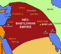 images: File:Neo_babylonia_empire_540_bc.svg licensed with PD-self 2008-10-25T21:11:03Z ChrisO 494x438 (285924 Bytes) [[Category:Maps of the Neo-Babylonian…(489 × 434 (60 KB)) - 03:49, 11. Sep. 2020
 operator: University of Texas Libraries URL: https://maps.lib.utexas.edu/maps/ams/central_honshu/txu-pclmaps-oclc-6615273-neo-5454-3-1944.jpg…(6.064 × 5.064 (8,49 MB)) - 12:26, 14. Apr. 2025
- elegante Paläste, Hotels, Wohnhäuser und Museen im Stil des Klassizismus, des Neo-Barocks und später des Jugendstils, bekannte europäische Architekten wie…209 KB (24.275 Wörter) - 09:27, 31. Aug. 2024
 (WT-shared) NeoSkyte[dead link] 749×561 (39097 bytes) {{Imagecredit|credit=NeoSkyte|captureDate=|location=Manitoba|source=|caption=Region map of…(356 × 551 (27 KB)) - 16:00, 22. Jan. 2025
 phases d'expansion de l'empire néo-assyrien (934-612 av. J.-C.). |en= Map showing different stage of the extension of the Neo-Assyrian Empire Uploaded with…(1.435 × 1.109 (1,68 MB)) - 07:21, 11. Jun. 2022
 Datei:Cyprus line-1.jpg (Kategorie Maps of Cyprus)following license: English Map of Cyprus in Armenian author name string: NeoCy Wikimedia username: NeoCy URL: https://commons.wikimedia.org/wiki/User:NeoCy…(4.510 × 2.840 (864 KB)) - 16:19, 4. Mär. 2025
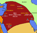 Datei:Neu-Babylonisches-Reich.png (Kategorie Maps of the Neo-Babylonian Empire)File:Neo_babylonia_empire_540_bc-2.png licensed with PD-self 2010-03-15T12:55:13Z ܥܝܪܐܩ 489x434 (61121 Bytes) {{Information |Description={{en|1=Map of the…(489 × 434 (57 KB)) - 05:02, 11. Sep. 2020
 Datei:Cy60 en.jpg (Kategorie Maps of Cyprus)wikipedia. 2009-10-04 20:44 Neo ^ 9458×5690× (14712862 bytes) Filename 2009-10-04 19:40 Neo ^ 9458×5690× (14712862 bytes) Full map, showing all settlements…(9.458 × 5.690 (14,03 MB)) - 15:46, 29. Apr. 2024
- Makadi Bay (Kategorie VCard: Parameter google-maps benutzt)59′ 56″ N 33° 54′ 9″ O)letzte Änderung: keine Angabe26.9989133.90251 4 JAZ Neo Makadi Saraya Palms (جاز مكادي سرايا بالمز, Jaz Saraya Palms), Hurghada-Safaga…44 KB (6.316 Wörter) - 11:57, 24. Apr. 2025
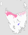 Datei:Population distribution map of the Tasmanian giant freshwater crayfish (Astacopsis gouldi).pngAttribution-Share Alike 4.0 truetrue English author name string: NeoGeneric Wikimedia username: NeoGeneric URL: http://commons.wikimedia.org/wiki/User:NeoGeneric…(674 × 838 (80 KB)) - 08:35, 6. Sep. 2024
 Datei:2024-austria-legislative-by-state-and-party-gradient.svg (Kategorie Election maps of the National Council (Austria))SPO, NEOS, Grune, others) author name string: MapperGuy87 Wikimedia username: MapperGuy87 URL: https://commons.wikimedia.org/wiki/User:MapperGuy87 determination…(1.007 × 819 (3,12 MB)) - 15:23, 15. Dez. 2024
 English Map of the Armenian Genocide in Greek Greek Χάρτης της Αρμενικής Γενοκτονίας στα Ελληνικά URL: https://commons.wikimedia.org/wiki/user:NeoCy Wikimedia…(8.040 × 4.752 (5,57 MB)) - 02:37, 15. Sep. 2023
- Kairo/Downtown (Kategorie VCard: Parameter google-maps benutzt)0450131.244342 3 Er-Raḥma-Moschee (مسجد الرحمة) . Moschee von 1926 in neo-mamlukischem Stil in unmittelbarer Nachbarschaft der armenisch-katholischen…42 KB (6.490 Wörter) - 08:39, 10. Mär. 2025
 English author name string: NeoRetro URL: https://commons.wikimedia.org/wiki/user:NeoRetro Wikimedia username: NeoRetro…(702 × 546 (32 KB)) - 14:54, 22. Okt. 2022
 wikipedia. 2010-02-03 13:26 NeoRetro 1231×929× (41644 bytes) Reverted to version as of 09:55, 21 August 2009 2010-02-03 13:26 NeoRetro 1231×929× (66824 bytes)…(1.231 × 929 (41 KB)) - 14:38, 25. Apr. 2023
 choice. This image is a derivative work of the following images: File:Empire_neo_babyloien.svg licensed with Cc-by-sa-3.0,2.5,2.0,1.0, GFDL 2010-11-19T20:31:53Z…(1.470 × 1.333 (2,16 MB)) - 21:24, 21. Feb. 2024
 Datei:Cyprus districts.svg (Kategorie Valid SVG created with Text Editor:Maps)2009-10-05T08:37:37Z NeoCy 8610x5270 (2826077 Bytes) 2009-09-09T07:12:56Z NeoCy 4305x2635 (965733 Bytes) {{Information |Description={{en|1=Map of Cyprus showing…(1.060 × 645 (151 KB)) - 08:29, 5. Jan. 2025
 a derivative work of the following images: File:Middle_East_topographic_map-blank.svg licensed with Cc-by-sa-3.0,2.5,2.0,1.0, GFDL 2010-11-03T17:52:56Z…(1.534 × 1.435 (3,27 MB)) - 03:00, 21. Jul. 2024
_-_S%C3%A8te_02.jpg)


.png)


Explore the world

United states
New York

Japan
Tokyo

Singapore
Singapore
