
 Français
 Italiano
Size of this preview: 340 × 600 pixels. Other resolutions: 136 × 240 pixels | 272 × 480 pixels | 748 × 1,319 pixels.
Original file (748 × 1,319 pixels, file size: 261 KB, MIME type: image/jpeg)
This is a file from the Wikimedia Commons and may be used by other projects. Information from its description page there is shown below. Commons is a freely licensed media file repository. |
Summary
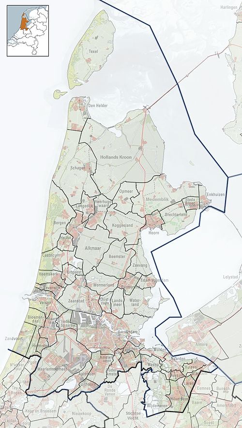
| Description | Nederlands: Referentiekaart van Provincie Noord-Holland, met indeling van gemeenten (2010) en impressie van het landschap. Door Jan-Willem van Aalst, samengesteld uit publiek beschikbare geo-data:
|
| Date | |
| Source | Own work |
| Author | Janwillemvanaalst |
Licensing
I, the copyright holder of this work, hereby publish it under the following license:
This file is licensed under the Creative Commons Attribution-Share Alike 3.0 Unported license.
- You are free:
- to share – to copy, distribute and transmit the work
- to remix – to adapt the work
- Under the following conditions:
- attribution – You must give appropriate credit, provide a link to the license, and indicate if changes were made. You may do so in any reasonable manner, but not in any way that suggests the licensor endorses you or your use.
- share alike – If you remix, transform, or build upon the material, you must distribute your contributions under the same or compatible license as the original.
File history
Click on a date/time to view the file as it appeared at that time.
| Date/Time | Thumbnail | Dimensions | User | Comment | |
|---|---|---|---|---|---|
| current | 20:47, 21 November 2014 | | 748 × 1,319 (261 KB) | Tristan Surtel | Added Alkmaar |
| 07:57, 3 January 2014 |  | 748 × 1,319 (262 KB) | Tristan Surtel | Version updated until January 1, 2014. This version has the new municipalities of Hollands Kroon, Súdwest Fryslân and Stichtse Vecht and the increased municipalities of Medemblik, Schagen and De Ronde Venen. | |
| 20:31, 15 January 2010 |  | 748 × 1,319 (214 KB) | Janwillemvanaalst | {{Information |Description={{nl|1=Referentiekaart van Provincie Noord-Holland, met indeling van gemeenten (2010) en impressie van het landschap. Door Jan-Willem van Aalst, samengesteld uit publiek beschikbare geo-data: * Referentie-ondergrond (kustlijn, s |
File usage
There are no pages that use this file.
Global file usage
The following other wikis use this file:
- Usage on ar.wikipedia.org
- Usage on bn.wikipedia.org
- Usage on ceb.wikipedia.org
- Usage on en.wikipedia.org
- Amsterdam Airport Schiphol
- Andijk
- Anna Paulowna
- Bennebroek
- Muiden
- Naarden
- Obdam
- Venhuizen
- Wervershoof
- Wognum
- Aagtdorp
- Bergen aan Zee
- Bregtdorp
- Camperduin
- Catrijp
- Egmond aan den Hoef
- Egmond aan Zee
- Egmond-Binnen
- Schoorldam
- Groet
- Hargen
- Schoorl
- Duivendrecht
- Marken
- Hoofddorp
- Nieuw-Vennep
- Zaandijk
- Aerdenhout
- Overveen
- Hoogkarspel
- Wijk aan Zee
- Assendelft
- Koog aan de Zaan
- Krommenie
- Westzaan
- Wormerveer
- Schellinkhout
- Hoogwoud
- Spanbroek
- Abbekerk
- Barsingerhorn
- Opperdoes
- Middenmeer
- Zwaag
- Broek in Waterland
View more global usage of this file.
Explore the world

United states
New York

Japan
Tokyo

Singapore
Singapore
