
 Français
 Italiano
Size of this PNG preview of this SVG file: 542 × 334 pixels. Other resolutions: 320 × 197 pixels | 640 × 394 pixels | 1,024 × 631 pixels | 1,280 × 789 pixels | 2,560 × 1,578 pixels.
Original file (SVG file, nominally 542 × 334 pixels, file size: 13.32 MB)
This is a file from the Wikimedia Commons and may be used by other projects. Information from its description page there is shown below. Commons is a freely licensed media file repository. |
Any autoconfirmed user can overwrite this file from the same source. Please ensure that overwrites comply with the guideline.
Summary
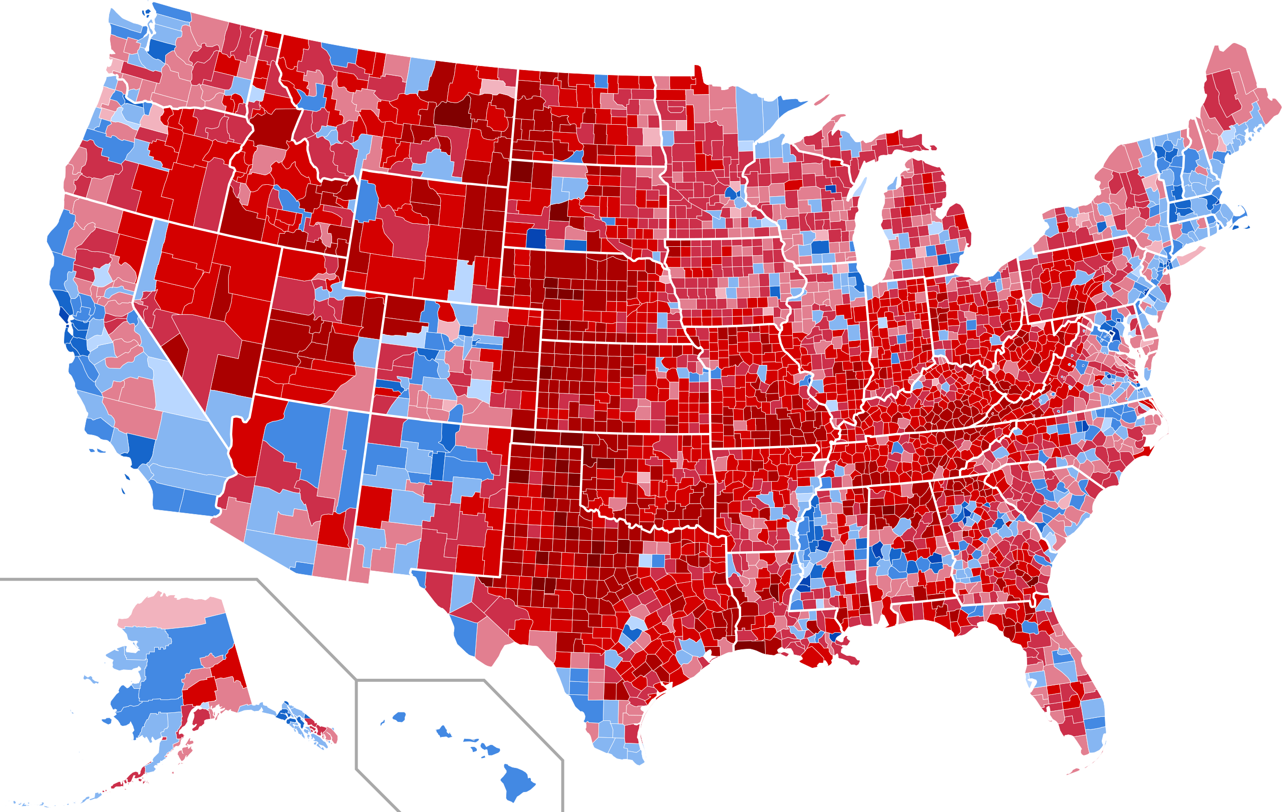
| Description | English: Results by county of the 2020 United States presidential election. Joe Biden—>90% Joe Biden—80-90% Joe Biden—70-80% Joe Biden—60-70% Joe Biden—50-60% Joe Biden—40-50% Joe Biden—<40% Donald Trump—<40% Donald Trump—40-50% Donald Trump—50-60% Donald Trump—60-70% Donald Trump—70-80% Donald Trump—80-90% Donald Trump—>90% |
| Date | |
| Source | This file was derived from: USA Counties with names.svg |
| Author | Magog the Ogre |
| SVG development |
Licensing
I, the copyright holder of this work, hereby publish it under the following license:
| This file is made available under the Creative Commons CC0 1.0 Universal Public Domain Dedication. | |
| The person who associated a work with this deed has dedicated the work to the public domain by waiving all of their rights to the work worldwide under copyright law, including all related and neighboring rights, to the extent allowed by law. You can copy, modify, distribute and perform the work, even for commercial purposes, all without asking permission.
|
File history
Click on a date/time to view the file as it appeared at that time.
| Date/Time | Thumbnail | Dimensions | User | Comment | |
|---|---|---|---|---|---|
| current | 04:17, 27 January 2025 | | 542 × 334 (13.32 MB) | GatewayPolitics | fix |
| 04:25, 27 November 2024 |  | 542 × 334 (13.32 MB) | Gordfather69 | Shapes | |
| 15:24, 23 March 2022 |  | 555 × 352 (1.45 MB) | Ngfsmg | Alaska | |
| 01:26, 20 September 2021 |  | 555 × 352 (1.49 MB) | Magog the Ogre | Reverted to version as of 13:01, 26 January 2021 (UTC) "fix" used the wrong width between counties | |
| 03:02, 20 July 2021 |  | 556 × 352 (910 KB) | TylerKutschbach | Fixed Alaska map | |
| 13:01, 26 January 2021 |  | 555 × 352 (1.49 MB) | Elli | Kalawao results (Biden got >90%) | |
| 16:28, 13 January 2021 |  | 555 × 352 (1.49 MB) | Politicsfan4 | Reverted to version as of 01:16, 31 December 2020 (UTC) whoops, my bad | |
| 16:26, 13 January 2021 |  | 555 × 352 (1.49 MB) | Politicsfan4 | Reverted to version as of 20:47, 25 December 2020 (UTC) the borders were more consistent with other maps | |
| 01:16, 31 December 2020 |  | 555 × 352 (1.49 MB) | Faustino Sojo | Borders | |
| 20:47, 25 December 2020 |  | 555 × 352 (1.49 MB) | Faustino Sojo | Alaska2 |
File usage
The following page uses this file:
Global file usage
The following other wikis use this file:
- Usage on de.wikipedia.org
- Usage on en.wikipedia.org
- 2020 United States presidential election
- User:DukeOfDelTaco/U.S. Presidential Elections
- User:DukeOfDelTaco/sandbox/Results of the 2020 United States presidential election
- User:Aghoulsparadise/sandbox
- User:Quanbruhismymiddlename/sandbox
- User:Frandźiši/sandbox
- User:Falcaorib/United States presidential elections
- User:Vqaeola/sandbox
- Usage on es.wikipedia.org
- Usage on fa.wikipedia.org
- Usage on frr.wikipedia.org
- Usage on fr.wikipedia.org
- Usage on fy.wikipedia.org
- Usage on he.wikipedia.org
- Usage on it.wikipedia.org
- Usage on ko.wikipedia.org
- Usage on no.wikipedia.org
- Usage on pt.wikipedia.org
Metadata
Explore the world

United states
New York

Japan
Tokyo

Singapore
Singapore
