
 Français
 Italiano
Size of this PNG preview of this SVG file: 583 × 599 pixels. Other resolutions: 233 × 240 pixels | 467 × 480 pixels | 747 × 768 pixels | 996 × 1,024 pixels | 1,992 × 2,048 pixels | 1,385 × 1,424 pixels.
Original file (SVG file, nominally 1,385 × 1,424 pixels, file size: 1.49 MB)
This is a file from the Wikimedia Commons and may be used by other projects. Information from its description page there is shown below. Commons is a freely licensed media file repository. |
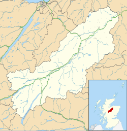
| Description | Map of the Badenoch and Strathspey ward, UK in 2011, with the following information shown:
Equirectangular map projection on WGS 84 datum, with N/S stretched 180% Geographic limits:
|
| Date | |
| Source |
|
| Author | Nilfanion, created using Ordnance Survey data |
| Permission (Reusing this file) | This file is licensed under the Creative Commons Attribution-Share Alike 3.0 Unported license. Attribution: Contains Ordnance Survey data © Crown copyright and database right
|
| Other versions | File:Badenoch and Strathspey UK blank map.svg - Blank map |
File history
Click on a date/time to view the file as it appeared at that time.
| Date/Time | Thumbnail | Dimensions | User | Comment | |
|---|---|---|---|---|---|
| current | 01:51, 20 February 2011 | | 1,385 × 1,424 (1.49 MB) | Nilfanion | {{Information |Description=Map of the Badenoch and Strathspey ward, UK in 2011, with the following information shown: *Ward boundaries *Coastline, lakes and rivers *Roads and railways *Urban areas Equirectangular map project |
File usage
There are no pages that use this file.
Global file usage
The following other wikis use this file:
- Usage on ar.wikipedia.org
- Usage on ceb.wikipedia.org
- Usage on en.wikipedia.org
- Kingussie
- Badenoch and Strathspey
- Ruthven Barracks
- Boat of Garten
- Advie
- Carrbridge
- Newtonmore
- Ruthven, Badenoch
- Laggan, Badenoch
- Dalwhinnie
- Cromdale
- Abernethy and Kincardine
- Nethy Bridge
- Dulnain Bridge
- Aviemore
- Kincraig
- Achnahannet, Strathspey
- Avielochan
- Alvie
- Aundorach
- Bogroy
- Insh
- Duthil
- Catlodge
- Kinloch Laggan
- Etteridge
- Dunachton
- Drumuillie
- Lynchat
- Skye of Curr
- Dalnavert, Highland
- Coylumbridge
- Inverdruie
- Template talk:Infobox UK place/Archive 12
- Module:Location map/data/Scotland Badenoch and Strathspey/doc
- Module:Location map/data/Scotland Badenoch and Strathspey
- Ian Charles Community Hospital
- St Vincent's Hospital, Kingussie
- Usage on es.wikipedia.org
- Usage on eu.wikipedia.org
- Usage on fa.wikipedia.org
- Usage on fr.wikipedia.org
- Usage on ga.wikipedia.org
- Usage on ja.wikipedia.org
View more global usage of this file.
Explore the world

United states
New York

Japan
Tokyo

Singapore
Singapore
