
 Français
 Italiano
Size of this PNG preview of this SVG file: 613 × 600 pixels. Other resolutions: 245 × 240 pixels | 490 × 480 pixels | 785 × 768 pixels | 1,046 × 1,024 pixels | 2,093 × 2,048 pixels | 702 × 687 pixels.
Original file (SVG file, nominally 702 × 687 pixels, file size: 676 KB)
This is a file from the Wikimedia Commons and may be used by other projects. Information from its description page there is shown below. Commons is a freely licensed media file repository. |
 | Standardization of derivative maps Feel free to create derivations of this work, but if you want to illustrate a Wikipedia article with derivative works of this or similar maps of Brazil, please strictly follow the visual standard, nomenclature and classification already in use. All maps of Brazilian subdivisions are being adaptated or created in this way. We do not want to inhibit creativity but the pattern adopted here was presented and accepted by the Lusophone community and should be followed whenever possible. |
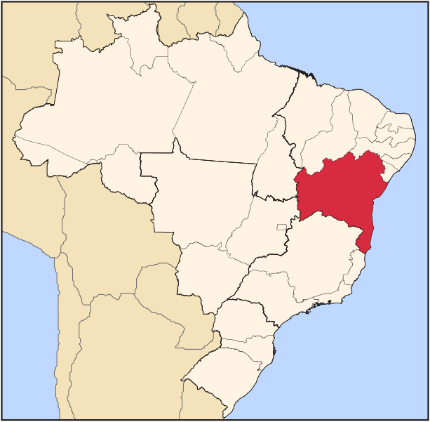
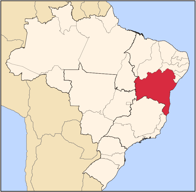
| Description | Map locator of Brazil's Bahia state | ||||||||
| Date | |||||||||
| Source | Own work | ||||||||
| Author | Raphael Lorenzeto de Abreu | ||||||||
| Permission (Reusing this file) | I, the copyright holder of this work, hereby publish it under the following licenses:
This file is licensed under the Creative Commons Attribution 2.5 Generic license.
You may select the license of your choice. |

File history
Click on a date/time to view the file as it appeared at that time.
| Date/Time | Thumbnail | Dimensions | User | Comment | |
|---|---|---|---|---|---|
| current | 03:10, 3 June 2006 | | 702 × 687 (676 KB) | Raphael.lorenzeto | |
| 02:50, 3 June 2006 |  | 702 × 687 (676 KB) | Raphael.lorenzeto | ||
| 02:53, 22 April 2006 |  | 702 × 687 (448 KB) | Raphael.lorenzeto | {{Information| |Description=Map locator of Brazil's Bahia state |Source=own work |Date=April, 21 2006 |Author=Raphael Lorenzeto de Abreu |Permission={{self2|GFDL|cc-by-2.5}} |other_versions= }} Category:Maps of Brazil |
File usage
There are no pages that use this file.
Global file usage
The following other wikis use this file:
- Usage on af.wikipedia.org
- Usage on ar.wikipedia.org
- Usage on arz.wikipedia.org
- Usage on be-tarask.wikipedia.org
- Usage on be.wikipedia.org
- Usage on bg.wikipedia.org
- Ирара
- Салвадор (Баия)
- Итабуна
- Баия
- Фейра ди Сантана
- Шаблон:Общини на Баия
- Бара (Баия)
- Алагоиняс
- Енкрузиляда
- Итороро
- Убатан
- Буритирама
- Иботирама
- Итагуасу да Баия
- Морпара
- Мукен ди Сао Франсиско
- Шики-Шики
- Бон Жезус да Лапа
- Кариняня
- Паратинга
- Сера до Рамальо
- Ситио ду Мато
- Фейра да Мата
- Жуазейро
- Каза Нова
- Кампо Алегри ди Лурдис
- Кураса
- Пилао Аркадо
- Ремансо
- Сенто Се
- Собрадиньо (Баия)
- Абаре
- Глория (Баия)
- Макуруре
- Пауло Афонсо
- Роделас
- Шорошо
- Барейрас
- Баянополис
- Католандия
- Луис Едуардо Магаляйнс
- Риашао дас Невис
- Сао Дезидерио
- Формоза до Рио Прето
View more global usage of this file.
Explore the world

United states
New York

Japan
Tokyo

Singapore
Singapore
