
 Français
 Italiano
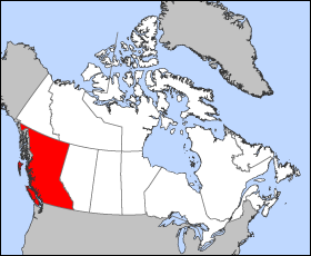
No higher resolution available.
British_Columbia-map.png (280 × 230 pixels, file size: 14 KB, MIME type: image/png)
This is a file from the Wikimedia Commons and may be used by other projects. Information from its description page there is shown below. Commons is a freely licensed media file repository. |
 | File:British Columbia, Canada.svg is a vector version of this file. It should be used in place of this PNG file when not inferior. File:British Columbia-map.png → File:British Columbia, Canada.svg For more information, see Help:SVG. |  |
Map of British Columbia
Projection: Lambert azimuthal equal-area
Geospatial data from: The Atlas of Canada, The National Atlas of the United States archive copy at the Wayback Machine and U.S. Geological Survey
Cartographer: John Fowler
| I, the copyright holder of this work, release this work into the public domain. This applies worldwide. In some countries this may not be legally possible; if so: I grant anyone the right to use this work for any purpose, without any conditions, unless such conditions are required by law. |
File history
Click on a date/time to view the file as it appeared at that time.
| Date/Time | Thumbnail | Dimensions | User | Comment | |
|---|---|---|---|---|---|
| current | 12:12, 24 March 2005 | | 280 × 230 (14 KB) | Voyager | Map of British Columbia Projection: Lambert azimuthal equal-area Geospatial data from: [http://atlas.gc.ca/ The Atlas of Canada], [http://www.nationalatlas.gov/ The National Atlas of the United States] and [http://www.usgs.gov U.S. Geological Survey] C |
File usage
There are no pages that use this file.
Global file usage
The following other wikis use this file:
- Usage on fr.wikipedia.org
- Usage on he.wikivoyage.org
Explore the world

United states
New York

Japan
Tokyo

Singapore
Singapore
