
 Français
 Italiano
Size of this preview: 800 × 548 pixels. Other resolutions: 320 × 219 pixels | 640 × 439 pixels | 1,024 × 702 pixels | 1,280 × 877 pixels | 1,669 × 1,144 pixels.
Original file (1,669 × 1,144 pixels, file size: 151 KB, MIME type: image/png)
This is a file from the Wikimedia Commons and may be used by other projects. Information from its description page there is shown below. Commons is a freely licensed media file repository. |
Summary
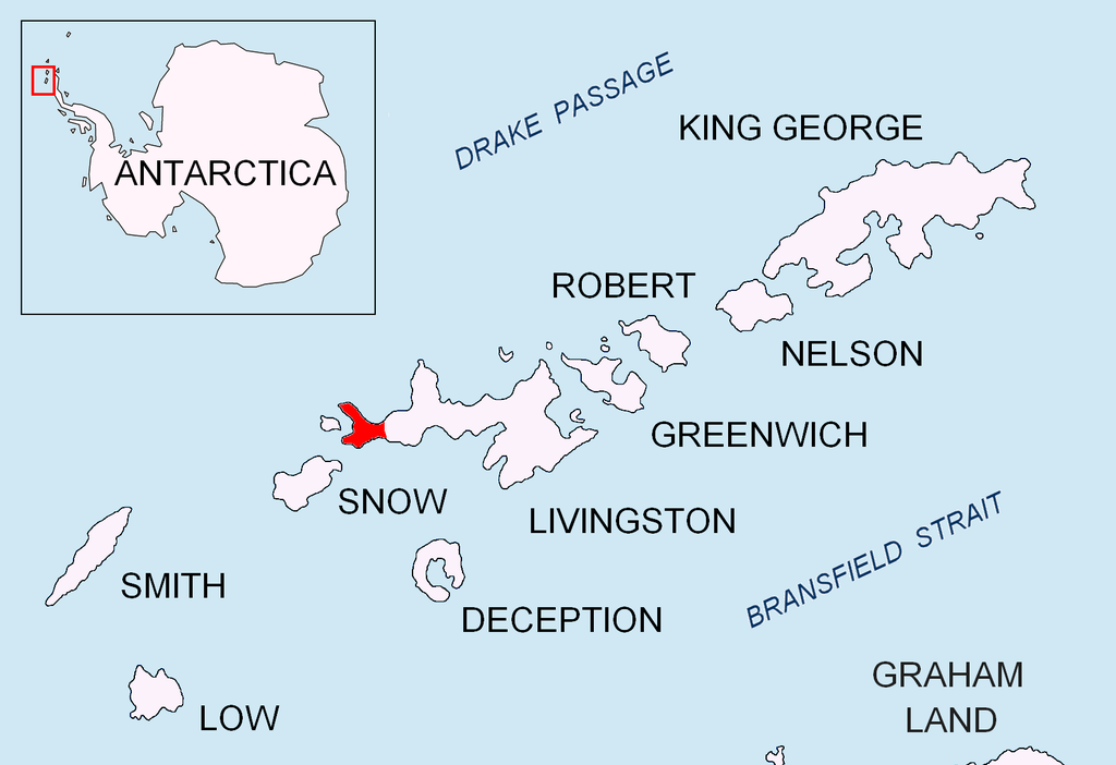
| Description | English: Location of Byers Peninsula on Livingston Island in the South Shetland Islands. |
| Date | |
| Source | Own work |
| Author | Apcbg |
Licensing
I, the copyright holder of this work, hereby publish it under the following licenses:
This file is licensed under the Creative Commons Attribution-Share Alike 3.0 Unported license.
- You are free:
- to share – to copy, distribute and transmit the work
- to remix – to adapt the work
- Under the following conditions:
- attribution – You must give appropriate credit, provide a link to the license, and indicate if changes were made. You may do so in any reasonable manner, but not in any way that suggests the licensor endorses you or your use.
- share alike – If you remix, transform, or build upon the material, you must distribute your contributions under the same or compatible license as the original.
 | Permission is granted to copy, distribute and/or modify this document under the terms of the GNU Free Documentation License, Version 1.2 or any later version published by the Free Software Foundation; with no Invariant Sections, no Front-Cover Texts, and no Back-Cover Texts. A copy of the license is included in the section entitled GNU Free Documentation License. |
You may select the license of your choice.
File history
Click on a date/time to view the file as it appeared at that time.
| Date/Time | Thumbnail | Dimensions | User | Comment | |
|---|---|---|---|---|---|
| current | 16:03, 24 August 2010 | | 1,669 × 1,144 (151 KB) | Apcbg | + location in Antarctica |
| 17:28, 1 May 2010 |  | 1,669 × 1,144 (5.47 MB) | Apcbg | {{Information |Description={{en|1=Location of Byers Peninsula on Livingston Island in the South Shetland Islands.}} |Source={{own}} |Author=Apcbg |Date=2010-05-01 |Permission= |other_versions= }} Category:Maps of Antarctica |
File usage
There are no pages that use this file.
Global file usage
The following other wikis use this file:
- Usage on az.wikipedia.org
- Usage on bg.wikipedia.org
- Usage on ca.wikipedia.org
- Usage on ceb.wikipedia.org
- Usage on en.wikipedia.org
- Nikopol Point
- Svishtov Cove
- Start Point (Livingston Island)
- President Beaches
- Byers Peninsula
- New Plymouth (Livingston Island)
- Devils Point
- Hell Gates
- Robbery Beaches
- Camp Byers
- Raskuporis Cove
- Belene Cove
- Kardzhali Point
- Ograzhden Cove
- Baba Tonka Cove
- Kukuzel Cove
- Sevar Point
- Dometa Point
- Urvich Wall
- Rish Point
- Isbul Point
- Drong Hill
- Dospey Heights
- Voyteh Point
- Aglen Point
- Tsamblak Hill
- Sparadok Point
- Dulo Hill
- Vardim Rocks
- Essex Point
- Chester Cone
View more global usage of this file.
Explore the world

United states
New York

Japan
Tokyo

Singapore
Singapore
