
 Français
 Italiano
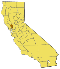
No higher resolution available.
California_map_showing_Napa_County.png (200 × 231 pixels, file size: 22 KB, MIME type: image/png)
This is a file from the Wikimedia Commons and may be used by other projects. Information from its description page there is shown below. Commons is a freely licensed media file repository. |
Map of Napa county in California. From en:
 | Permission is granted to copy, distribute and/or modify this document under the terms of the GNU Free Documentation License, Version 1.2 or any later version published by the Free Software Foundation; with no Invariant Sections, no Front-Cover Texts, and no Back-Cover Texts. A copy of the license is included in the section entitled GNU Free Documentation License. |
| This file is licensed under the Creative Commons Attribution-Share Alike 3.0 Unported license. | ||
| ||
| This licensing tag was added to this file as part of the GFDL licensing update. |
File history
Click on a date/time to view the file as it appeared at that time.
| Date/Time | Thumbnail | Dimensions | User | Comment | |
|---|---|---|---|---|---|
| current | 15:22, 14 July 2005 | | 200 × 231 (22 KB) | Pyramide~commonswiki | Map of Napa county in California. From en: {{GFDL}} Category:Maps of counties in California |
File usage
There are no pages that use this file.
Global file usage
The following other wikis use this file:
- Usage on bg.wikipedia.org
- Usage on en.wikipedia.org
- Arts Council of Napa Valley
- Template:NapaCountyCA-geo-stub
- Circle Oaks, California
- Napa Sonoma Marsh
- Milliken Creek (California)
- Pope Valley, California
- Vichy Springs, Napa County, California
- Robert Louis Stevenson State Park
- Zinfandel, California
- Napa Junction, California
- The Palisades (Napa County)
- Yountville Hills
- Iron Mountain (Napa County, California)
- Snell Valley
- Snell Creek
- Missimer Wildflower Preserve
- Caymus, California
- Cuttings Wharf, California
- Enchanted Hills, California
- Howell Mountain, California
- Imola, California
- Knoxville, California
- Lokoya, California
- Napa Soda Springs, California
- Redbud Park, California
- Sanitarium, California
- Shipyard Acres, California
- Tuluka, California
- Duvall Lake
- Berryessa Highlands, California
- Rector Reservoir
- Zim Zim Falls
- Domaine Carneros
- Little Island (California)
- Coon Island (California)
- Edgerly Island
- Green Island (California)
- Island No. 1
- Zem Zem Springs
- Usage on li.wikipedia.org
- Usage on pam.wikipedia.org
- Usage on sv.wikipedia.org
- Usage on www.wikidata.org
Explore the world

United states
New York

Japan
Tokyo

Singapore
Singapore
