
 Français
 Italiano
Size of this JPG preview of this PDF file: 337 × 599 pixels. Other resolutions: 135 × 240 pixels | 270 × 480 pixels | 432 × 768 pixels | 575 × 1,024 pixels | 1,289 × 2,293 pixels.
Original file (1,289 × 2,293 pixels, file size: 1,011 KB, MIME type: application/pdf)
This is a file from the Wikimedia Commons and may be used by other projects. Information from its description page there is shown below. Commons is a freely licensed media file repository. |
Summary
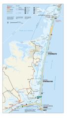
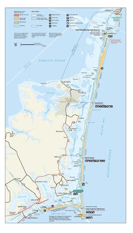
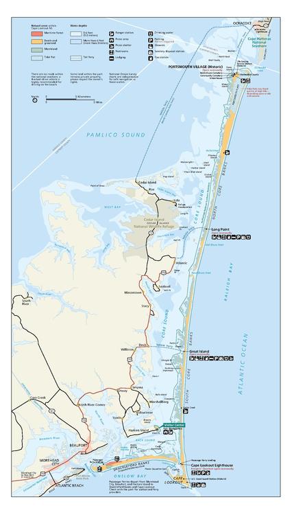
| Description | English: The Cape Lookout National Seashore official park map, shows the locations of key points of interest, visitor centers, and ferry landings. |
| Date | accessed 2013 |
| Source | |
| Author | Cape Lookout National Seashore |
Licensing
| This image or media file contains material based on a work of a National Park Service employee, created as part of that person's official duties. As a work of the U.S. federal government, such work is in the public domain in the United States. See the NPS website and NPS copyright policy for more information. |
File history
Click on a date/time to view the file as it appeared at that time.
| Date/Time | Thumbnail | Dimensions | User | Comment | |
|---|---|---|---|---|---|
| current | 02:05, 2 August 2013 |  | 1,289 × 2,293 (1,011 KB) | Jarekt | {{Information |Description ={{en|1=The Cape Lookout National Seashore official park map shows the locations of key points of interest, visitor centers, and ferry landings.}} |Source =http://www.nps.gov/calo/planyourvisit/maps.htm |Author ... |
File usage
There are no pages that use this file.
Global file usage
The following other wikis use this file:
- Usage on en.wikipedia.org
Metadata
Explore the world

United states
New York

Japan
Tokyo

Singapore
Singapore
