
 Français
 Italiano
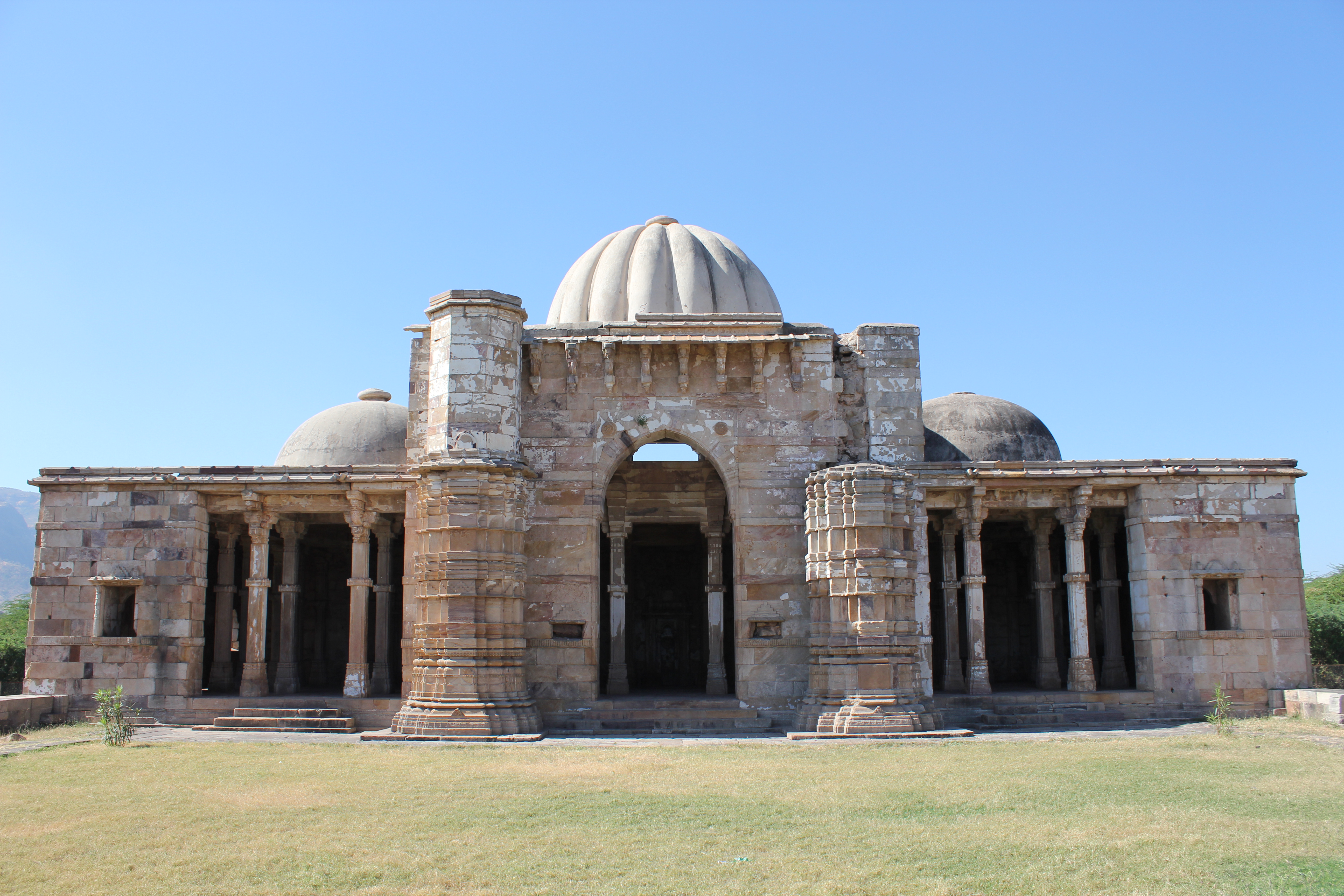
Original file (5,184 × 3,456 pixels, file size: 6.46 MB, MIME type: image/jpeg)
This is a file from the Wikimedia Commons and may be used by other projects. Information from its description page there is shown below. Commons is a freely licensed media file repository. |
.jpg)
Summary
| Description | Champaner, Lila Gumbaj Ki Masjid Champaner, also known as Muhammadabad, is a historical city in the state of Gujarat, in western India. The city was briefly the capital of Gujarat. It was founded by Vanraj Chavda, the most prominent king of the Chavda Dynasty, in the 8th century. He named it after the name of his friend and general Champa, also known later as Champaraj. By the later 15th century, the Khichi Chauhan Rajputs held Pavagadh fort above the town of Champaner. The young Sultan of Gujarat, Mahmud Begada, deciding to attack Champaner, started towards it with his army on 4 December 1482. After defeating the Champaner army, Mahmud captured the town and besieged Pavagadh, the well-known hill-fortress, above Champaner, where king Jayasimha had taken refuge. He captured the Pavagadh fort on 21 November 1484, after a siege of 20 months. He then spent 23 years rebuilding and embellishing Champaner, which he renamed Muhammadabad, after which he moved the capital there from Ahmedabad. In 1535, after chasing away Bahadur Shah, Humayun personally led some 300 Mughals to scale the fort on spikes driven into rock and stonework in a remote and unguarded part of the citadel built over a precipitous hillside on Pavagadh Hill. Large heaps of gold, silver and jewels were the war booty even though Bahadur Shah had managed to escape to Diu. Champaner is today the site of the Champaner-Pavagadh Archaeological Park, which UNESCO designated a World Heritage Site in 2004. There are eleven different types of buildings at the UNESCO-protected Champaner-Pavagadh Archaeological Park, including mosques, temples, granaries, tombs, wells, walls, and terraces. The monuments are situated at the foot of and around the Pavagadh Hill. The Baroda Heritage Trust lists 114 monuments in the area, of which only 39 are maintained by the Archeological Survey of India, due to limited funding. Lila Gumbaj Ki Masjid, built on a high plinth, has a frontage with an arched entrance at the centre flanked by two lateral arches. Initially, three entrances existed on the east, south, and north directions. There are well spaced minarets fashioned with horizontal cornices and mouldings, and decorated niches. Of the three domes, the central one has a fluted design and is colourful. On the north-east corner there is a rectangular ablution tank with a deep drain in front. Inside the mosque, there are three mehrabs in the prayer hall and these are decorated with a central suspended kalash carved with floral motifs. (source: en.wikipedia.org/wiki/Champaner, en.wikipedia.org/wiki/Monuments_of_Champaner-Pavagadh_Arc..., and en.wikipedia.org/wiki/Lila_Gumbaj_Ki_Masjid,_Champaner) |
| Date | |
| Source | Champaner, Lila Gumbaj Ki Masjid |
| Author | Arian Zwegers from Brussels, Belgium |
| Camera location | | View this and other nearby images on: OpenStreetMap |
|---|
.jpg¶ms=022.490830_N_0073.541039_E_globe:Earth_type:camera_source:Flickr_&language=en)
Licensing
- You are free:
- to share – to copy, distribute and transmit the work
- to remix – to adapt the work
- Under the following conditions:
- attribution – You must give appropriate credit, provide a link to the license, and indicate if changes were made. You may do so in any reasonable manner, but not in any way that suggests the licensor endorses you or your use.
| This image was originally posted to Flickr by Arian Zwegers at https://flickr.com/photos/67769030@N07/9840188055. It was reviewed on 8 March 2016 by FlickreviewR and was confirmed to be licensed under the terms of the cc-by-2.0. |
File history
Click on a date/time to view the file as it appeared at that time.
| Date/Time | Thumbnail | Dimensions | User | Comment | |
|---|---|---|---|---|---|
| current | 20:08, 8 March 2016 | | 5,184 × 3,456 (6.46 MB) | Shipjustgotreal | Transferred from Flickr via Flickr2Commons |
File usage
The following page uses this file:
Global file usage
The following other wikis use this file:
- Usage on en.wikipedia.org
- Usage on www.wikidata.org
Metadata
.jpg)
Explore the world

United states
New York

Japan
Tokyo

Singapore
Singapore
