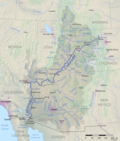
Size of this preview: 509 × 600 pixels. Other resolutions: 204 × 240 pixels | 407 × 480 pixels | 652 × 768 pixels | 869 × 1,024 pixels | 1,399 × 1,648 pixels.
Original file (1,399 × 1,648 pixels, file size: 3.53 MB, MIME type: image/png)
File history
Click on a date/time to view the file as it appeared at that time.
| Date/Time | Thumbnail | Dimensions | User | Comment | |
|---|---|---|---|---|---|
| current | 05:02, 20 September 2019 |  | 1,399 × 1,648 (3.53 MB) | Shannon1 | fixed great divide basin boundary |
| 18:32, 11 May 2018 |  | 1,399 × 1,649 (3.53 MB) | Shannon1 | Corrected "Boulder" label to Fort Collins | |
| 21:57, 26 January 2018 |  | 1,514 × 1,773 (4.32 MB) | Shannon1 | {{Information |Description ={{en|1=Map of the Colorado River drainage basin, created using USGS data. Intended to replace [https://en.wikipedia.org/wiki/File:Coloradorivermapnew1.jpg older map]}} |Source =Own work |Author =[[User:Sha... |
File usage
There are no pages that use this file.
Global file usage
The following other wikis use this file:
- Usage on af.wikipedia.org
- Usage on ar.wikipedia.org
- Usage on az.wikipedia.org
- Usage on ba.wikipedia.org
- Usage on bh.wikipedia.org
- Usage on bn.wikipedia.org
- Usage on cv.wikipedia.org
- Usage on da.wikipedia.org
- Usage on de.wikipedia.org
- Usage on de.wikivoyage.org
- Usage on el.wikipedia.org
- Usage on en.wikipedia.org
- Usage on eo.wikipedia.org
- Usage on es.wikipedia.org
- Usage on fa.wikipedia.org
- Usage on fi.wikipedia.org
- Usage on fr.wikipedia.org
- Usage on he.wikipedia.org
- Usage on hif.wikipedia.org
- Usage on hr.wikipedia.org
- Usage on is.wikipedia.org
- Usage on ja.wikipedia.org
- Usage on ko.wikipedia.org
- Usage on lv.wikipedia.org
- Usage on ml.wikipedia.org
- Usage on mn.wikipedia.org
- Usage on ms.wikipedia.org
- Usage on nn.wikipedia.org
View more global usage of this file.


 Français
 Italiano


