
 Français
 Italiano
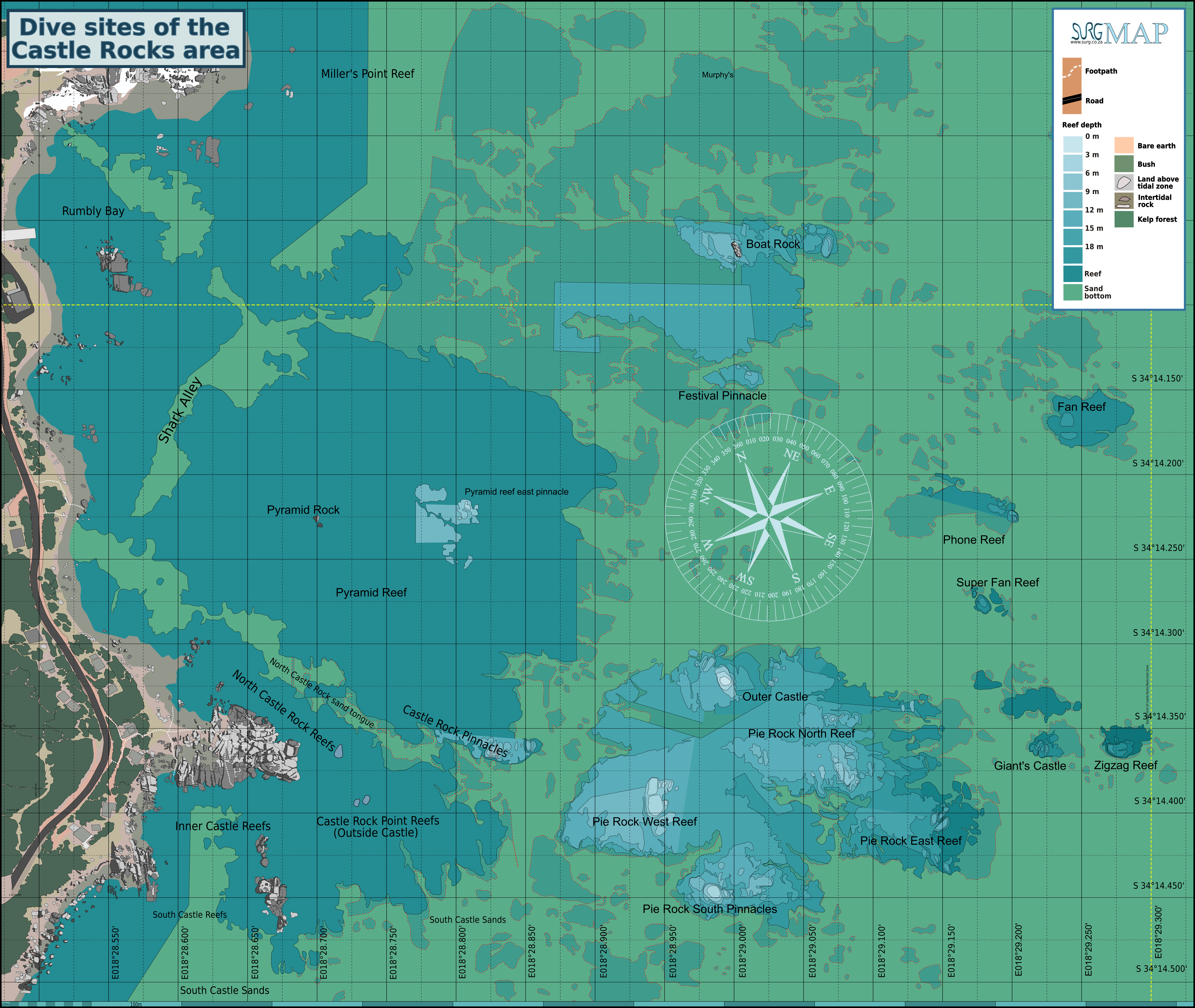
Size of this preview: 711 × 600 pixels. Other resolutions: 285 × 240 pixels | 569 × 480 pixels | 911 × 768 pixels | 1,214 × 1,024 pixels | 2,429 × 2,048 pixels | 7,313 × 6,167 pixels.
Original file (7,313 × 6,167 pixels, file size: 6.74 MB, MIME type: image/png)
This is a file from the Wikimedia Commons and may be used by other projects. Information from its description page there is shown below. Commons is a freely licensed media file repository. |
Summary
| Description | English: Map of the dive sites in the area between Miller's Point and the sand south of Castle Rocks, Cape Peninsula. |
| Date | |
| Source | Peter Southwood |
| Author | Peter Southwood, F.W. van Zyl |
Licensing
User: (WT-shared) Pbsouthwood at wts wikivoyage, the copyright holder of this work, hereby publishes it under the following license:
This file is licensed under the Creative Commons Attribution-Share Alike 3.0 Unported license.
Attribution: User: (WT-shared) Pbsouthwood at wts wikivoyage
- You are free:
- to share – to copy, distribute and transmit the work
- to remix – to adapt the work
- Under the following conditions:
- attribution – You must give appropriate credit, provide a link to the license, and indicate if changes were made. You may do so in any reasonable manner, but not in any way that suggests the licensor endorses you or your use.
- share alike – If you remix, transform, or build upon the material, you must distribute your contributions under the same or compatible license as the original.
Original upload log
| This file was imported from Wikivoyage WTS. |
The original description page was here. All following user names refer to wts.wikivoyage-old.
org:
- 2011-05-28 06:55 (WT-shared) Pbsouthwood[dead link] 3007×2402 (1153715 bytes) {{Imagecredit|credit=Peter Southwood|captureDate=May 2011|location=Cape Peninsula|source=Peter Southwood|caption=Map of the dive sites in th (Import from wikitravel.org/shared)
- 2011-07-04 11:49 (WT-shared) Pbsouthwood[dead link] 3017×2402 (1857732 bytes) Updated with reef from South African Council for Geoscience Acoustic Facies Interpretation of the Table Mountain Marine Protected Area, shee (Import from wikitravel.org/shared)
- 2012-09-10 08:39 Pbsouthwood[dead link] 3000×2389 (1851999 bytes) rm logo
File history
Click on a date/time to view the file as it appeared at that time.
| Date/Time | Thumbnail | Dimensions | User | Comment | |
|---|---|---|---|---|---|
| current | 15:51, 2 August 2021 | | 7,313 × 6,167 (6.74 MB) | Pbsouthwood | Update Pie Rock 18m contour |
| 07:25, 8 June 2021 |  | 7,313 × 6,167 (6.69 MB) | Pbsouthwood | added Super Fan Reef | |
| 11:53, 8 February 2021 |  | 7,313 × 6,167 (6.75 MB) | Pbsouthwood | Pie Rock area updates | |
| 18:19, 15 September 2019 |  | 7,313 × 6,167 (6.49 MB) | Pbsouthwood | format changes | |
| 17:50, 15 September 2019 |  | 7,313 × 5,822 (6.33 MB) | Pbsouthwood | several updates | |
| 04:01, 13 December 2012 |  | 3,000 × 2,389 (1.77 MB) | OgreBot | (BOT): Reverting to most recent version before archival | |
| 04:01, 13 December 2012 |  | 3,017 × 2,402 (1.77 MB) | OgreBot | (BOT): Uploading old version of file from wts.wikivoyage; originally uploaded on 2011-07-04 11:49:52 by (WT-shared) Pbsouthwood | |
| 04:00, 13 December 2012 |  | 3,007 × 2,402 (1.1 MB) | OgreBot | (BOT): Uploading old version of file from wts.wikivoyage; originally uploaded on 2011-05-28 06:55:10 by (WT-shared) Pbsouthwood | |
| 19:14, 15 November 2012 |  | 3,000 × 2,389 (1.77 MB) | MGA73bot2 | {{BotMoveToCommons|wts.oldwikivoyage|year={{subst:CURRENTYEAR}}|month={{subst:CURRENTMONTHNAME}}|day={{subst:CURRENTDAY}}}} == {{int:filedesc}} == {{Information |description=Map of the dive sites in the area between Miller's Point and the sand south of... |
File usage
The following 4 pages use this file:
Metadata
Explore the world

United states
New York

Japan
Tokyo

Singapore
Singapore
