
 Français
 Italiano
Size of this PNG preview of this SVG file: 505 × 600 pixels. Other resolutions: 202 × 240 pixels | 404 × 480 pixels | 647 × 768 pixels | 862 × 1,024 pixels | 1,725 × 2,048 pixels | 1,099 × 1,305 pixels.
Original file (SVG file, nominally 1,099 × 1,305 pixels, file size: 1.61 MB)
This is a file from the Wikimedia Commons and may be used by other projects. Information from its description page there is shown below. Commons is a freely licensed media file repository. |
Summary
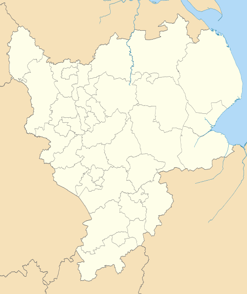
| Description | Map of the East Midlands region showing the administrative districts. Equirectangular map projection on WGS 84 datum, with N/S stretched 165% Geographic limits:
|
| Date | |
| Source |
|
| Author | Nilfanion, created using Ordnance Survey data |
| Other versions | Derivative works of this file: |
Licensing
I, the copyright holder of this work, hereby publish it under the following licenses:
This file is licensed under the Creative Commons Attribution-Share Alike 3.0 Unported license.
- You are free:
- to share – to copy, distribute and transmit the work
- to remix – to adapt the work
- Under the following conditions:
- attribution – You must give appropriate credit, provide a link to the license, and indicate if changes were made. You may do so in any reasonable manner, but not in any way that suggests the licensor endorses you or your use.
- share alike – If you remix, transform, or build upon the material, you must distribute your contributions under the same or compatible license as the original.
 | Permission is granted to copy, distribute and/or modify this document under the terms of the GNU Free Documentation License, Version 1.2 or any later version published by the Free Software Foundation; with no Invariant Sections, no Front-Cover Texts, and no Back-Cover Texts. A copy of the license is included in the section entitled GNU Free Documentation License. |
You may select the license of your choice.
File history
Click on a date/time to view the file as it appeared at that time.
| Date/Time | Thumbnail | Dimensions | User | Comment | |
|---|---|---|---|---|---|
| current | 18:55, 1 May 2011 | | 1,099 × 1,305 (1.61 MB) | Nilfanion | == Summary == {{Information |Description=Map of the East Midlands region showing the administrative districts. Equirectangular map projection on WGS 84 datum, with N/S stretched 165% Geographic limits: *West: 2.1W *East: 0.4E *North: |
File usage
There are no pages that use this file.
Global file usage
The following other wikis use this file:
- Usage on en.wikipedia.org
- Lincoln, England
- Nottingham
- Leicester
- East Midlands
- Northampton
- Midlands
- Amber Valley
- High Peak, Derbyshire
- Oadby and Wigston
- North West Leicestershire
- Borough of Charnwood
- Blaby District
- Hinckley and Bosworth
- Derbyshire Dales
- North East Derbyshire
- Jewry Wall
- East Lindsey
- West Lindsey
- South Kesteven
- Harborough District
- Borough of Melton
- South Derbyshire
- Borough of Erewash
- Ashfield District
- Bassetlaw District
- Borough of Broxtowe
- South Holland District
- North Kesteven
- Newark and Sherwood
- Rushcliffe
- Borough of Gedling
- Template:East Midlands
- Borough of Boston
- Bolsover District
- Mansfield District
- United Counties League
- Edward Rossiter
- User talk:Nilfanion
- User:Phildav76/Regional templates
- University of Leicester Botanic Garden
- Ulmus minor 'Plotii'
- NOW Leicester
- Ashington End
- Derby County F.C.–Nottingham Forest F.C. rivalry
- Wikipedia:WikiProject Countries/Templates/Navboxes/European country subdivisions
- Midlands 5 East (North)
- Derby
- Regional 2 East Midlands
- Midlands 4 East (North)
- Midlands 3 East (North)
View more global usage of this file.
Explore the world

United states
New York

Japan
Tokyo

Singapore
Singapore
