
 Français
 Italiano
Size of this PNG preview of this SVG file: 500 × 500 pixels. Other resolutions: 240 × 240 pixels | 480 × 480 pixels | 768 × 768 pixels | 1,024 × 1,024 pixels | 2,048 × 2,048 pixels.
Original file (SVG file, nominally 500 × 500 pixels, file size: 119 KB)
This is a file from the Wikimedia Commons and may be used by other projects. Information from its description page there is shown below. Commons is a freely licensed media file repository. |
Summary
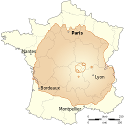
| Description | English: Comparison between size of France and Olympus Mons (planet Mars), the highest mountain in the solar system. Français : Comparaison entre les tailles de la France et d'Olympus Mons (planète Mars), la plus haute montagne du système solaire. | ||
| Date | (UTC) | ||
| Source | |||
| Author |
| ||
| Other versions | |||
| Attribution (required by the license) | © Sémhur / Wikimedia Commons / | ||
| SVG | W3C-validity not checked.
| ||
| Graphic Lab |
Licensing
I, the copyright holder of this work, hereby publish it under the following licenses:
| Copyleft: This work of art is free; you can redistribute it and/or modify it according to terms of the Free Art License. You will find a specimen of this license on the Copyleft Attitude site as well as on other sites. |
This file is licensed under the Creative Commons Attribution-Share Alike 4.0 International, 3.0 Unported, 2.5 Generic, 2.0 Generic and 1.0 Generic license.
- You are free:
- to share – to copy, distribute and transmit the work
- to remix – to adapt the work
- Under the following conditions:
- attribution – You must give appropriate credit, provide a link to the license, and indicate if changes were made. You may do so in any reasonable manner, but not in any way that suggests the licensor endorses you or your use.
- share alike – If you remix, transform, or build upon the material, you must distribute your contributions under the same or compatible license as the original.
You may select the license of your choice.
Original upload log
This image is a derivative work of the following images:
- File:Départements_et_régions_de_France.svg licensed with PD-self
- 2008-06-20T07:26:42Z Bayo 588x550 (478078 Bytes) patch region/departement id with ISO 3166-2:FR
- 2008-06-17T09:02:28Z Bayo 588x550 (485696 Bytes) {{Information |Description= |Source= |Date= |Author= |Permission= |other_versions= }}
- 2008-05-10T16:56:23Z Bayo 588x550 (470290 Bytes) region name bigger, patch typo of some names
- 2006-05-22T20:34:29Z Bayo 588x550 (470278 Bytes) patch : typo
- 2006-04-17T15:11:41Z Bayo 588x550 (470275 Bytes) ajout de l'échelle
- 2006-04-17T14:45:23Z Bayo 588x550 (465538 Bytes) *'''description''' : Départements et régions et de France avec leurs préfectures. *'''auteur''' : [[User:bayo|bayo]] [[Category:Maps of departements of France]] [[Category:Maps of régions of France]] == Licensing == {{P
- File:Olympus_Mons_alt.jpg licensed with PD-USGov-NASA
- 2008-12-22T19:18:16Z Diego pmc 2020x1883 (3747949 Bytes) == Summary == {{Information |Description={{en|A composite image of [[:en:Olympus Mons|Olympus Mons]] on [[:en:Mars|Mars]], the tallest known [[:en:Volcano|volcano]] and [[:en:Mountain|mountain]] in the [[Solar System]].}} |So
Uploaded with derivativeFX
File history
Click on a date/time to view the file as it appeared at that time.
| Date/Time | Thumbnail | Dimensions | User | Comment | |
|---|---|---|---|---|---|
| current | 15:10, 26 May 2014 | | 500 × 500 (119 KB) | Sémhur | Valid SVG |
| 15:54, 30 March 2009 |  | 500 × 500 (119 KB) | Sémhur | {{Information |Description={{en|Departements and region of France. French geographics objects use ISO 3166-2:FR for ids.}} {{es|Mapa de los departamentos franceses.}} {{fr|Départements et régions de France avec leurs préfectures. Les objects géographi |
File usage
There are no pages that use this file.
Global file usage
The following other wikis use this file:
- Usage on en.wikipedia.org
- Usage on es.wikipedia.org
- Usage on fa.wikipedia.org
- Usage on fi.wikipedia.org
- Usage on fr.wikipedia.org
- Usage on he.wikipedia.org
- Usage on hr.wikipedia.org
- Usage on it.wikipedia.org
- Usage on ko.wikipedia.org
- Usage on mr.wikipedia.org
- Usage on my.wikipedia.org
- Usage on nap.wikipedia.org
- Usage on ro.wikipedia.org
- Usage on sl.wikipedia.org
Metadata
Explore the world

United states
New York

Japan
Tokyo

Singapore
Singapore
