
 Français
 Italiano
Original file (SVG file, nominally 1,574 × 1,738 pixels, file size: 836 KB)
This is a file from the Wikimedia Commons and may be used by other projects. Information from its description page there is shown below. Commons is a freely licensed media file repository. |
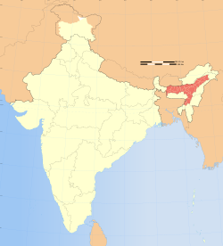
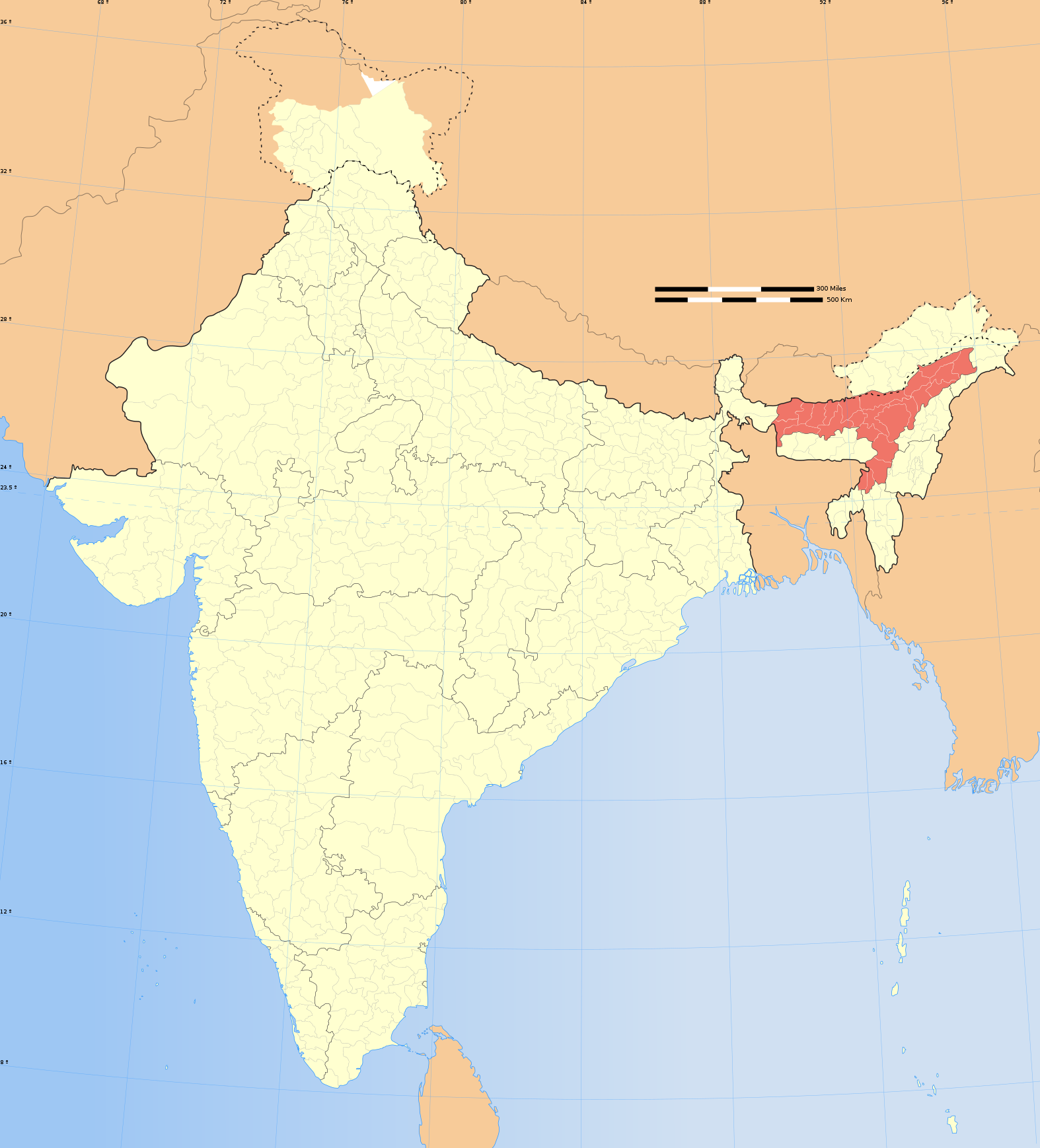
| Title | Assam locator map | |||||||||
| Description | ||||||||||
| Map legend |  | |||||||||
| Date | ||||||||||
| Source | Own work | |||||||||
| Creator |
| |||||||||
| Permission (Reusing this file) | I, the copyright holder of this work, hereby publish it under the following license: This file is licensed under the Creative Commons Attribution-Share Alike 3.0 Unported license.
| |||||||||
| Geotemporal data | ||||||||||
| Date depicted | second half of 20th century and 21st century | |||||||||
| Spatial reference system | conic | |||||||||
| Bounding box |
| |||||||||
| Georeferencing | If inappropriate please set warp_status = skip to hide. | |||||||||
| Archival data | ||||||||||
| Notes | Part of WikiProject India Maps | |||||||||
| Other versions |
| |||||||||


Notes
Depiction of India's borders
- The territorial boundaries of India are shown as per the actual ground situation in accordance with international practices followed by the United Nations ([1], [2]) and the National Geographic Society ([3], [4])
- This map is meant to be for illustrative purpose only and is not authenticated by official government sources. Please check the list of sources and references used to create the map for a measure of accuracy and verifiability.
- The usage of these maps in India, Pakistan and China are governed by different laws that restrict depictions of boundaries other than what is officially recognized by the state. Please check local laws and modify the map accordingly before use.
Explanation of disputed boundaries


- Boundary of Indian claim : The territory India claims is legally theirs, but the claim is disputed by China and Pakistan.
- Line of Control/Line of Conflict : The de facto administrative boundary recognised by the international community. This UN ceasefire line is considered as a temporary solution to an ongoing conflict since the departure of the British Raj.
Borders of disputed regions
The depicted extent of the former territory of the British Indian Empire, succeeded by Republic of India, may not be accepted by few countries as legal due to ongoing border disputes:
- The northern Himalayan region of the disputed territory Indian-administered Kashmir is claimed by India including (Pakistan-administered Kashmir) and the Chinese-occupied territory of (Ladakh plateau). Since 1972, it is divided between all three countries. See also Line of Control and Line of Actual Control.
- Siachen glacier (shown white) is an actively contested region between India and Pakistan. Since 1984, the region is under Indian control.
- The northeastern territory of Arunachal Pradesh is almost entirely claimed by China as part of its Tibetan territory.
- Minor areas of eastern Kashmir's Ladakh division, Himachal Pradesh and Uttarakhand on the Chinese frontier are claimed by China. These areas are under Indian control.
- A small area of Uttarakhand adjoining the Nepal border along the Sarda river is disputed between the two countries.
For a detailed map of all disputed regions in South Asia, see Image:India disputed areas map.svg
Internal borders
The borders of the state of Meghalaya, Assam and Arunachal Pradesh are shown as interpreted from the North-Eastern Areas (Reorganisation) Act, 1971, but has yet to be verified.
Territorial waters
The limit of the territorial waters of India extends to twelve nautical miles measured from the appropriate baseline. See this for more information.
File history
Click on a date/time to view the file as it appeared at that time.
| Date/Time | Thumbnail | Dimensions | User | Comment | |
|---|---|---|---|---|---|
| current | 06:26, 29 December 2008 | | 1,574 × 1,738 (836 KB) | Planemad | |
| 17:56, 6 August 2006 |  | 1,639 × 1,852 (751 KB) | Planemad | {{WikiProject_India_Maps |Title=Assam locator map |Description=Locator map of the state of Assam, India with district boundaries. |Source=. |Date=August 6 2006 |Author=w:user:Nichalpw:user:Planemad |Thumbdir=CHANGE }} |
File usage
There are no pages that use this file.
Global file usage
The following other wikis use this file:
- Usage on as.wikipedia.org
- অসম
- তেজপুৰ
- বৰপেটা
- যোৰহাট
- উত্তৰ লখিমপুৰ
- সদস্য:Anshuman.jrt/নলবাৰী
- সদস্য:Anshuman.jrt/শিলচৰ
- গহপুৰ
- বিশ্বনাথ চাৰিআলি
- বঙাইগাঁও
- ঢকুৱাখনা
- নাৰায়ণপুৰ
- পাঠশালা
- কাজিৰঙা ৰাষ্ট্ৰীয় উদ্যান
- বৰদৈবাম বিলমুখ পক্ষী উদ্যান
- বিহপুৰীয়া (নগৰ)
- কোকৰাঝাৰ
- কৰিমগঞ্জ
- হাৰিভাংগা
- সোণাৰি
- অসমৰ ৰাজ্যিক প্ৰতীকসমূহ
- কৈহাটী
- মাণিকপুৰ
- পবিতৰা অভয়াৰণ্য
- মঙলদৈ
- তিতাবৰ মহকুমা
- ডিফু
- মৰিগাঁও
- মাখিবাহা
- ঘিলামৰা
- বালিপৰা
- চাৰিদুৱাৰ
- শ্বহীদ মুকুন্দ কাকতি উচ্চ মাধ্যমিক বিদ্যালয়
- ২০২২ চনত অসমৰ বানপানী
- ভূৰাগাঁও
- ফুলবাৰী
- Usage on ba.wikipedia.org
- Usage on be.wikipedia.org
- Usage on bn.wikipedia.org
- Usage on br.wikipedia.org
- Usage on cdo.wikipedia.org
- Usage on cy.wikipedia.org
- Usage on de.wikinews.org
- Usage on dty.wikipedia.org
- Usage on dv.wikipedia.org
- Usage on en.wikipedia.org
View more global usage of this file.
Explore the world

United states
New York

Japan
Tokyo

Singapore
Singapore
