
 Français
 Italiano
Size of this PNG preview of this SVG file: 537 × 600 pixels. Other resolutions: 215 × 240 pixels | 430 × 480 pixels | 687 × 768 pixels | 916 × 1,024 pixels | 1,833 × 2,048 pixels | 776 × 867 pixels.
Original file (SVG file, nominally 776 × 867 pixels, file size: 406 KB)
This is a file from the Wikimedia Commons and may be used by other projects. Information from its description page there is shown below. Commons is a freely licensed media file repository. |
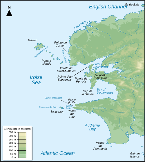
| Description | Français : Carte topographique du Finistère et de la mer d'Iroise en France : version anglais English: Topographic map of Finistère in France and iroise sea : english version |
| Date | (UTC) |
| Source | |
| Author |
|
I, the copyright holder of this work, hereby publish it under the following licenses:
This file is licensed under the Creative Commons Attribution-Share Alike 3.0 Unported, 2.5 Generic, 2.0 Generic and 1.0 Generic license.
- You are free:
- to share – to copy, distribute and transmit the work
- to remix – to adapt the work
- Under the following conditions:
- attribution – You must give appropriate credit, provide a link to the license, and indicate if changes were made. You may do so in any reasonable manner, but not in any way that suggests the licensor endorses you or your use.
- share alike – If you remix, transform, or build upon the material, you must distribute your contributions under the same or compatible license as the original.
 | Permission is granted to copy, distribute and/or modify this document under the terms of the GNU Free Documentation License, Version 1.2 or any later version published by the Free Software Foundation; with no Invariant Sections, no Front-Cover Texts, and no Back-Cover Texts. A copy of the license is included in the section entitled GNU Free Documentation License. |
You may select the license of your choice.
Original upload log
This image is a derivative work of the following images:
- File:Iroise_sea_map-fr.svg licensed with Cc-by-sa-3.0,2.5,2.0,1.0, GFDL
- 2007-12-04T22:29:59Z Korrigan 776x867 (415667 Bytes) typo
- 2007-12-04T17:12:22Z Pinpin 776x867 (415667 Bytes) labels in italic
- 2007-12-04T17:10:18Z Pinpin 776x867 (415667 Bytes) add labels
- 2007-12-03T20:00:04Z Pinpin 776x867 (421079 Bytes)
- 2007-12-03T19:58:04Z Pinpin 776x867 (420757 Bytes) {{Information |Description={{fr|Carte topographique du Finistère et de la mer d'Iroise en France : version française}} {{en|Topographic map of Finistère in France and iroise sea : french version}} |Source=Own work Topograp
Uploaded with derivativeFX
File history
Click on a date/time to view the file as it appeared at that time.
| Date/Time | Thumbnail | Dimensions | User | Comment | |
|---|---|---|---|---|---|
| current | 14:24, 3 September 2009 | | 776 × 867 (406 KB) | Magicpiano | {{Information |Description={{fr|Carte topographique du Finistère et de la mer d'Iroise en France : version anglais}} {{en|Topographic map of Finistère in France and iroise sea : english version}} |Source=*File:Iroise_sea_map-fr.svg |Date=2009-09-0 |
File usage
There are no pages that use this file.
Global file usage
The following other wikis use this file:
- Usage on az.wikipedia.org
- Usage on da.wikipedia.org
- Usage on en.wikipedia.org
- Usage on fi.wikipedia.org
- Usage on he.wikipedia.org
- Usage on ja.wikipedia.org
- Usage on mk.wikipedia.org
- Usage on nl.wikipedia.org
Explore the world

United states
New York

Japan
Tokyo

Singapore
Singapore
