
 Français
 Italiano
Size of this PNG preview of this SVG file: 334 × 599 pixels. Other resolutions: 134 × 240 pixels | 267 × 480 pixels | 428 × 768 pixels | 571 × 1,024 pixels | 1,142 × 2,048 pixels | 601 × 1,078 pixels.
Original file (SVG file, nominally 601 × 1,078 pixels, file size: 1.62 MB)
This is a file from the Wikimedia Commons and may be used by other projects. Information from its description page there is shown below. Commons is a freely licensed media file repository. |
Summary
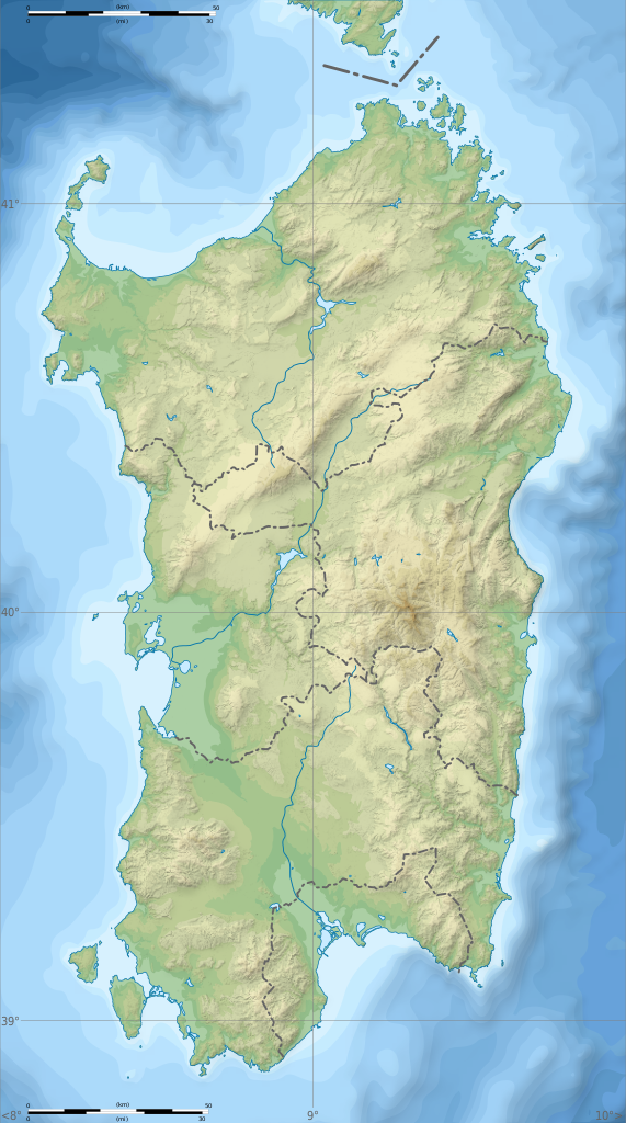
| Description | English: Blank physical map of Sardinia, Italy, for geo-location purpose, with province boundaries. Altitude levels : 25m, 50, 100, 200, 400, 600, etc. (same for bathymetry). Français : Carte topographique vierge de la Sardaigne, Italie, destinée à la géolocalisation, avec les limites des provinces. Niveaux d'altitudes : 25 m, 50, 100, 200, 400, 600, etc. Idem pour la bathymétrie.
Geographic limits of the map:
|
| Date | (UTC) |
| Source | Own work
|
| Author | Sémhur |
| Other versions | Derivative works of this file: Aree protette della Sardegna.svg
|
| Attribution (required by the license) | © Sémhur / Wikimedia Commons / |
| SVG | W3C-validity not checked. |
| Atelier graphique |

| Camera location | | View this and other nearby images on: OpenStreetMap |
|---|
Licensing
I, the copyright holder of this work, hereby publish it under the following licenses:
| Copyleft: This work of art is free; you can redistribute it and/or modify it according to terms of the Free Art License. You will find a specimen of this license on the Copyleft Attitude site as well as on other sites. |
This file is licensed under the Creative Commons Attribution-Share Alike 4.0 International, 3.0 Unported, 2.5 Generic, 2.0 Generic and 1.0 Generic license.
- You are free:
- to share – to copy, distribute and transmit the work
- to remix – to adapt the work
- Under the following conditions:
- attribution – You must give appropriate credit, provide a link to the license, and indicate if changes were made. You may do so in any reasonable manner, but not in any way that suggests the licensor endorses you or your use.
- share alike – If you remix, transform, or build upon the material, you must distribute your contributions under the same or compatible license as the original.
You may select the license of your choice.
File history
Click on a date/time to view the file as it appeared at that time.
| Date/Time | Thumbnail | Dimensions | User | Comment | |
|---|---|---|---|---|---|
| current | 15:26, 4 March 2018 | | 601 × 1,078 (1.62 MB) | Ruthven | c:User:Rillke/bigChunkedUpload.js: |
| 09:29, 25 February 2018 |  | 601 × 1,078 (1.62 MB) | Ruthven | New province boundaries (2016) | |
| 15:29, 24 January 2010 |  | 601 × 1,078 (1.63 MB) | Sémhur | == {{int:filedesc}} == {{Information |Description= {{en|Blank physical map of Sardinia, Italy, for geo-location purpose, with province boundaries. Altitude levels : 25m, 50, 100, 200, 400, 600, etc. (same for bathymetry)}} {{fr|Carte topo |
File usage
There are no pages that use this file.
Global file usage
The following other wikis use this file:
- Usage on ar.wikipedia.org
- Usage on az.wikipedia.org
- Usage on ba.wikipedia.org
- Usage on be.wikipedia.org
- Usage on bn.wikipedia.org
- Usage on bs.wikipedia.org
- Usage on ca.wikipedia.org
- Usage on ceb.wikipedia.org
- Usage on ce.wikipedia.org
- Usage on cs.wikipedia.org
- Usage on de.wikipedia.org
- Usage on de.wikivoyage.org
- Cagliari
- Olbia
- Alghero
- Sassari
- Oristano
- Nuoro
- Arbatax
- Sinis-Halbinsel
- Modul:Location map data it-88
- Modul:Location map data it-88/Doku
- Orosei
- Sos Alinos
- Budoni
- Posada (Sardinien)
- Valledoria
- Golfo Aranci
- Argentiera
- Porto Torres
- Bosa
- Cuglieri
- Macomer
- Abbasanta
- Arborea
- Terralba
- Tharros
- San Giovanni di Sinis
- Santuario nuragico Santa Cristina
- Carbonia
- Iglesias
- Villacidro
- Guspini
View more global usage of this file.
Metadata
Explore the world

United states
New York

Japan
Tokyo

Singapore
Singapore
