
 Français
 Italiano
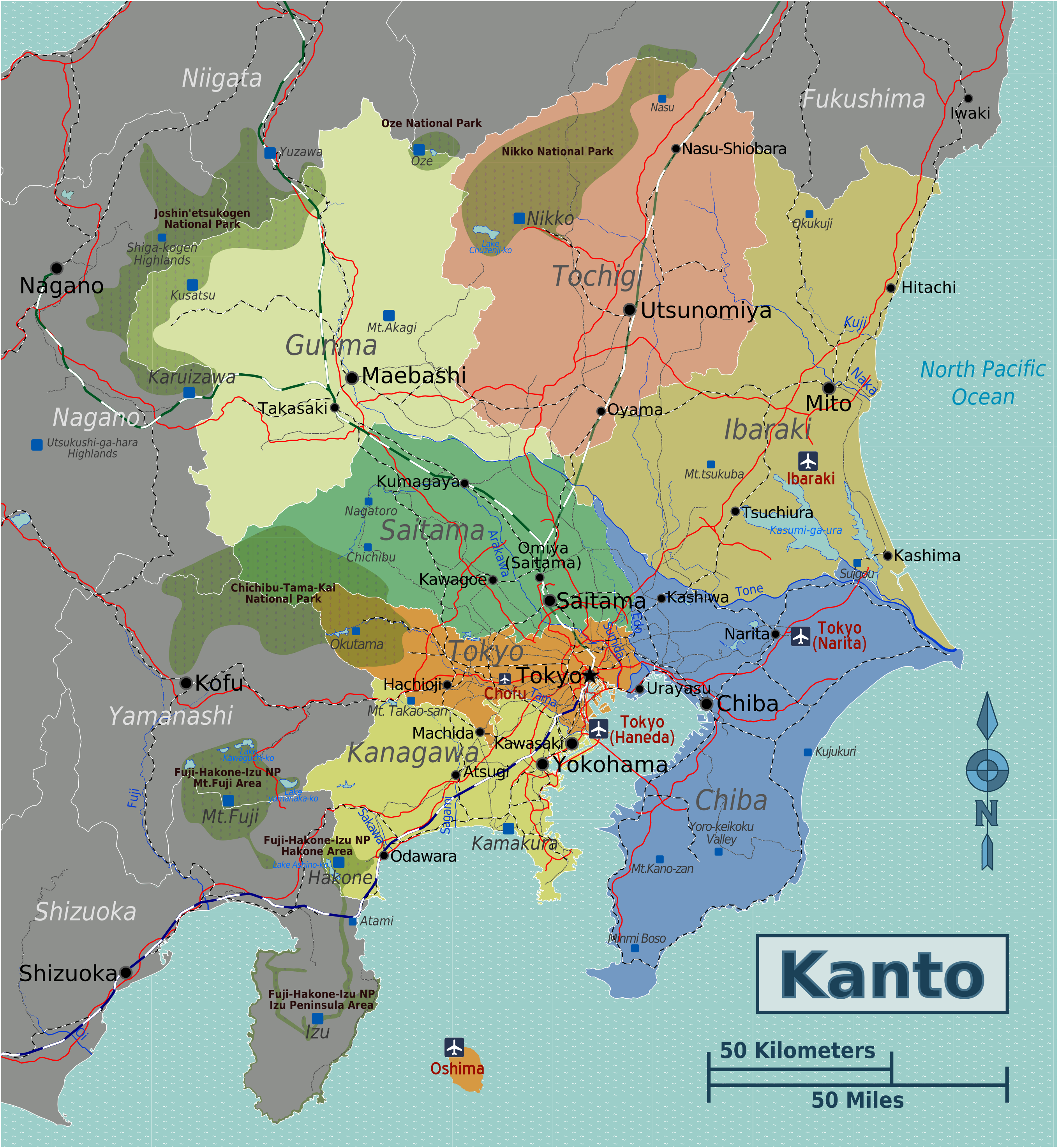
Size of this preview: 553 × 600 pixels. Other resolutions: 221 × 240 pixels | 442 × 480 pixels | 708 × 768 pixels | 944 × 1,024 pixels | 1,888 × 2,048 pixels | 2,716 × 2,946 pixels.
Original file (2,716 × 2,946 pixels, file size: 2.37 MB, MIME type: image/png)
This is a file from the Wikimedia Commons and may be used by other projects. Information from its description page there is shown below. Commons is a freely licensed media file repository. |
Summary
| Description | English: Map of the Kanto region, kanto. |
| Date | |
| Source | |
| Author | T.kambayashi |
Licensing
This file is licensed under the Creative Commons Attribution-Share Alike 3.0 Unported license.
- You are free:
- to share – to copy, distribute and transmit the work
- to remix – to adapt the work
- Under the following conditions:
- attribution – You must give appropriate credit, provide a link to the license, and indicate if changes were made. You may do so in any reasonable manner, but not in any way that suggests the licensor endorses you or your use.
- share alike – If you remix, transform, or build upon the material, you must distribute your contributions under the same or compatible license as the original.
Original upload log
| This file was imported from Wikivoyage WTS. |
The original description page was here. All following user names refer to wts.wikivoyage-old.
- 2011-08-20 15:02 (WT-shared) Kambayashi[dead link] 2716×2946 (2486261 bytes) (Import from wikitravel.org/shared)
File history
Click on a date/time to view the file as it appeared at that time.
| Date/Time | Thumbnail | Dimensions | User | Comment | |
|---|---|---|---|---|---|
| current | 00:18, 18 November 2012 | | 2,716 × 2,946 (2.37 MB) | MGA73bot2 | {{BotMoveToCommons|wts.oldwikivoyage|year={{subst:CURRENTYEAR}}|month={{subst:CURRENTMONTHNAME}}|day={{subst:CURRENTDAY}}}} == {{int:filedesc}} == {{Information |description=Map of the Kanto region. , kanto * Map of: Kanto¤ |date=20 August 2011 |sourc... |
File usage
The following page uses this file:
Global file usage
The following other wikis use this file:
- Usage on es.wikivoyage.org
- Usage on frr.wikipedia.org
- Usage on fr.wikivoyage.org
- Usage on he.wikivoyage.org
- Usage on incubator.wikimedia.org
- Usage on it.wikivoyage.org
- Usage on ja.wikivoyage.org
- Usage on mdf.wikipedia.org
- Usage on pt.wikivoyage.org
- Usage on ru.wikivoyage.org
- Usage on www.wikidata.org
Metadata
Explore the world

United states
New York

Japan
Tokyo

Singapore
Singapore
