
 Français
 Italiano
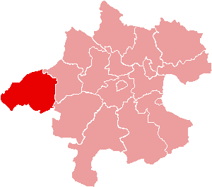
No higher resolution available.
Karte_Aut_Ooe_BR.png (300 × 265 pixels, file size: 4 KB, MIME type: image/png)
This is a file from the Wikimedia Commons and may be used by other projects. Information from its description page there is shown below. Commons is a freely licensed media file repository. |
Summary
| Description | Location of Bezirk Braunau am Inn within the Land of Upper Austria |
| Date | |
| Source | de:Bild:Karte Aut Ooe BR.png |
| Author | de:Benutzer:Plp |
| Permission (Reusing this file) | GFDL-author (licence from German Wikipedia) |
| Other versions | de:Bild:Karte Aut Ooe BR.png |
Licensing
 | Permission is granted to copy, distribute and/or modify this document under the terms of the GNU Free Documentation License, Version 1.2 or any later version published by the Free Software Foundation; with no Invariant Sections, no Front-Cover Texts, and no Back-Cover Texts. A copy of the license is included in the section entitled GNU Free Documentation License. |
| This file is licensed under the Creative Commons Attribution-Share Alike 3.0 Unported license. | ||
| ||
| This licensing tag was added to this file as part of the GFDL licensing update. |
File history
Click on a date/time to view the file as it appeared at that time.
| Date/Time | Thumbnail | Dimensions | User | Comment | |
|---|---|---|---|---|---|
| current | 14:58, 23 June 2006 | | 300 × 265 (4 KB) | Physchim62 | {{Information |Description=Location of Bezirk Braunau am Inn within the Land of Upper Austria |Source=de:Bild:Karte Aut Ooe BR.png |Date=2004 |Author=[[:de:Benutzer:Plp |Permis |
File usage
There are no pages that use this file.
Global file usage
The following other wikis use this file:
- Usage on ban.wikipedia.org
- Usage on bs.wikipedia.org
- Usage on cs.wikipedia.org
- Usage on de.wikipedia.org
- Braunau am Inn
- Hochburg-Ach
- Höhnhart
- Maria Schmolln
- Altheim (Oberösterreich)
- Franking
- Haigermoos
- Mattighofen
- Mauerkirchen
- Mining
- Polling im Innkreis
- St. Johann am Walde
- Tarsdorf
- Treubach
- Überackern
- Weng im Innkreis
- Moosdorf
- Vorlage:Navigationsleiste Städte und Gemeinden im Bezirk Braunau
- Feldkirchen bei Mattighofen
- Schwand im Innkreis
- Aspach (Oberösterreich)
- Auerbach (Oberösterreich)
- Eggelsberg
- Gilgenberg am Weilhart
- Handenberg
- Helpfau-Uttendorf
- Jeging
- Kirchberg bei Mattighofen
- Lengau
- Lochen am See
- Moosbach (Oberösterreich)
- Munderfing
- Neukirchen an der Enknach
- Ostermiething
- Palting
- Perwang am Grabensee
- Pfaffstätt
- Pischelsdorf am Engelbach
- Roßbach (Oberösterreich)
- St. Georgen am Fillmannsbach
- St. Pantaleon (Oberösterreich)
- St. Peter am Hart
View more global usage of this file.
Explore the world

United states
New York

Japan
Tokyo

Singapore
Singapore
