
 Français
 Italiano
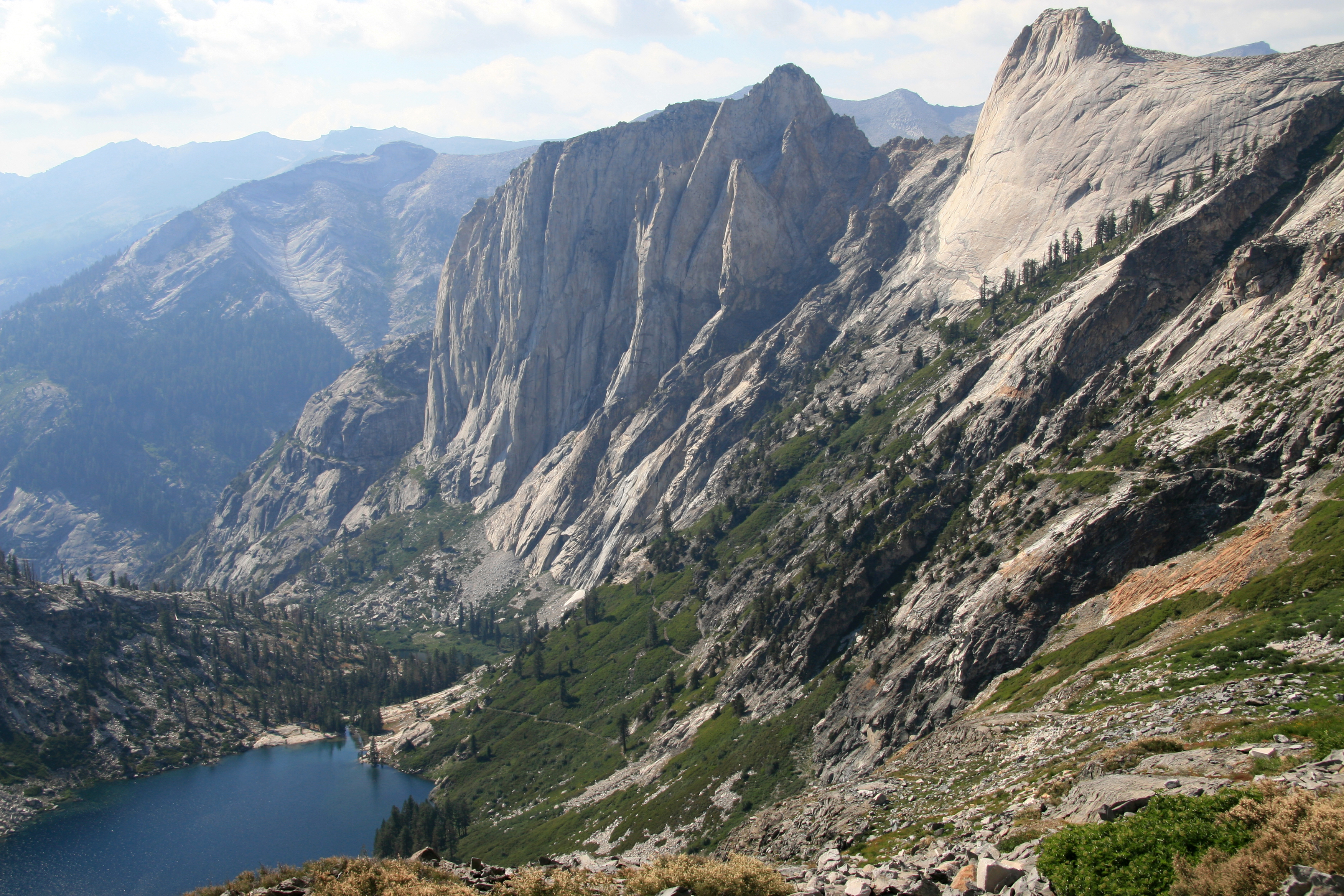
Size of this preview: 800 × 533 pixels. Other resolutions: 320 × 213 pixels | 640 × 427 pixels | 1,024 × 683 pixels | 1,280 × 853 pixels | 2,560 × 1,707 pixels | 3,504 × 2,336 pixels.
Original file (3,504 × 2,336 pixels, file size: 5.74 MB, MIME type: image/jpeg)
This is a file from the Wikimedia Commons and may be used by other projects. Information from its description page there is shown below. Commons is a freely licensed media file repository. |
Summary
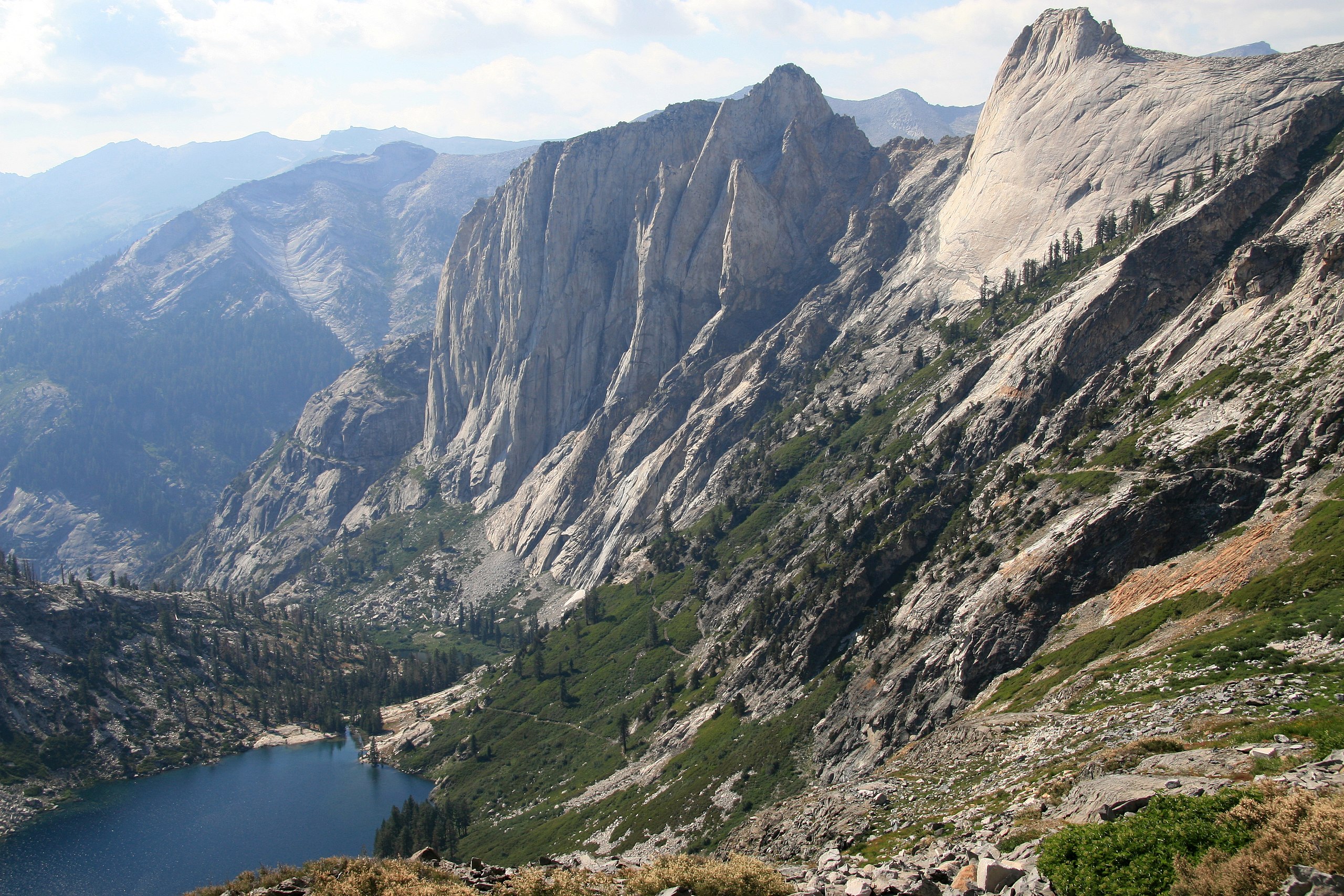
| Description | English: View looking down valley from the bowl under Kaweah Gap, Sequoia National Park, California. Shows Hamilton Lake, the Valhalla cliffs, and the High Sierra Trail switchbacking up. |
| Date | |
| Source | Own work |
| Author | Jane S. Richardson (talk · contribs) |
| Camera location | | View this and other nearby images on: OpenStreetMap |
|---|
Licensing
I, the copyright holder of this work, hereby publish it under the following license:
This file is licensed under the Creative Commons Attribution 3.0 Unported license.
- You are free:
- to share – to copy, distribute and transmit the work
- to remix – to adapt the work
- Under the following conditions:
- attribution – You must give appropriate credit, provide a link to the license, and indicate if changes were made. You may do so in any reasonable manner, but not in any way that suggests the licensor endorses you or your use.
File history
Click on a date/time to view the file as it appeared at that time.
| Date/Time | Thumbnail | Dimensions | User | Comment | |
|---|---|---|---|---|---|
| current | 00:34, 26 January 2009 | | 3,504 × 2,336 (5.74 MB) | Dcrjsr | {{Information |Description={{en|1=View looking down valley from the bowl under Kaweah Gap. Shows Hamilton Lake, the Valhalla cliffs, and the High Sierra Trail switchbacking up.}} |Source=Own work by uploader |Author=Dcrjsr |Date=August 3, |
File usage
There are no pages that use this file.
Global file usage
The following other wikis use this file:
- Usage on bg.wikipedia.org
- Usage on br.wikipedia.org
- Usage on ca.wikipedia.org
- Usage on en.wikipedia.org
- Lone Pine, California
- Lemon Cove, California
- Three Rivers, California
- Tulare, California
- Visalia, California
- John Muir Trail
- John Muir
- Mount Whitney
- John Tyndall
- General Sherman Tree
- Sequoia National Park
- Wikipedia:Selected anniversaries/September
- Wikipedia:Selected anniversaries/September 25
- Talk:September 25
- Josiah Whitney
- Stephen Mather
- Washington Tree
- Moro Rock
- Generals Highway
- Yokuts
- Mount Muir
- Mineral King
- Kaweah Peaks Ridge
- Black Kaweah
- Mount Kaweah
- Red Kaweah
- Kaweah Queen
- High Sierra Trail
- Kaweah River
- Great Western Divide
- Mount Langley
- Mount Russell (California)
- Mount Tyndall
- Giant Forest
- Crystal Cave (Sequoia National Park)
- Mount Barnard (California)
- Lilliput Glacier
- Eagle Lake (Tulare County)
- Kern Plateau salamander
- Sawtooth Peak
- Table Mountain (Tulare County, California)
- Kaweah Gap
- Ursa Minor (cave)
- Forester Pass
- Mount Le Conte (California)
- Florence Peak (California)
- Triple Divide Peak (Tulare County, California)
View more global usage of this file.
Metadata
Explore the world

United states
New York

Japan
Tokyo

Singapore
Singapore
