
 Français
 Italiano
Size of this PNG preview of this SVG file: 661 × 403 pixels. Other resolutions: 320 × 195 pixels | 640 × 390 pixels | 1,024 × 624 pixels | 1,280 × 780 pixels | 2,560 × 1,561 pixels.
Original file (SVG file, nominally 661 × 403 pixels, file size: 209 KB)
This is a file from the Wikimedia Commons and may be used by other projects. Information from its description page there is shown below. Commons is a freely licensed media file repository. |
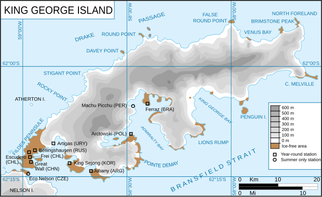
| Description | King George Island map. Detailed. Relief. Research Stations. Français : Carte de l'île du Roi-George. Relief et stations de recherches English: King George Island map. Detailed. Relief. Research Stations. |
| Date | (UTC) |
| Source | |
| Author |
|
| Other versions | Derivative works of this file: |
.svg)
.svg)
| This is a retouched picture, which means that it has been digitally altered from its original version. Modifications: english version of the french one. The original can be viewed here: Ile du roi-George (carte-fr).svg:
|
This file is licensed under the Creative Commons Attribution-Share Alike 3.0 Unported license.
- You are free:
- to share – to copy, distribute and transmit the work
- to remix – to adapt the work
- Under the following conditions:
- attribution – You must give appropriate credit, provide a link to the license, and indicate if changes were made. You may do so in any reasonable manner, but not in any way that suggests the licensor endorses you or your use.
- share alike – If you remix, transform, or build upon the material, you must distribute your contributions under the same or compatible license as the original.
Original upload log
This image is a derivative work of the following images:
- File:Kgeorge_map.png licensed with Cc-by-sa-3.0-migrated, GFDL
- 2008-01-22T13:13:50Z Wadim 660x402 (303141 Bytes) {{Information |Description= King George Island map. Detailed. Relief. Research Stations. Modificado 22.01.2008: Quito la firma, añado denominación historica en ruso. |Source= |Date= 06-May-2006 |Author= Giovanni Fattori |P
- 2006-05-06T17:51:48Z Gi 660x402 (307135 Bytes) {{Information |Description= King George Island map. Detailed. Relief. Research Stations. |Source= |Date= 06-May-2006 |Author= Giovanni Fattori |Permission= GNU free licence |other_versions= }}
- File:Ile_du_roi-George_(carte-fr).svg licensed with Cc-by-sa-3.0-migrated, GFDL
- 2010-04-18T21:10:06Z Trex 661x403 (266284 Bytes) {{Information |Description={{fr|1=Carte de l'île du Roi-George. Relief et stations de recherches}} {{en|1=King George Island map. Detailed. Relief. Research Stations.}} |Source=*[[:File:Kgeorge_map.png|]] |Date=2010-04-18 21:07
Uploaded with derivativeFX
File history
Click on a date/time to view the file as it appeared at that time.
| Date/Time | Thumbnail | Dimensions | User | Comment | |
|---|---|---|---|---|---|
| current | 12:22, 14 June 2010 | | 661 × 403 (209 KB) | Treehill | {{Information |Description=King George Island map. Detailed. Relief. Research Stations. {{fr|Carte de l'île du Roi-George. Relief et stations de recherches}} {{en|King George Island map. Detailed. Relief. Research Stations.}} |Source=*[[:File:Kgeorge_map |
File usage
There are no pages that use this file.
Global file usage
The following other wikis use this file:
- Usage on ar.wikipedia.org
- Usage on ca.wikipedia.org
- Usage on cs.wikipedia.org
- Usage on en.wikipedia.org
- King George Island (South Shetland Islands)
- Fildes Peninsula
- Base Presidente Eduardo Frei Montalva
- Trinity Church (Antarctica)
- Anna Glacier
- Baranowski Glacier
- Usher Glacier
- Noble Glacier
- Krak Glacier
- Domeyko Glacier
- Poetry Glacier
- Polar Club Glacier
- Ecology Glacier
- Eldred Glacier
- Flagstaff Glacier
- Goetel Glacier
- Stenhouse Glacier
- Lange Glacier
- Usage on es.wikipedia.org
- Usage on fr.wikipedia.org
- Usage on he.wikipedia.org
- Usage on it.wikipedia.org
- Usage on ka.wikipedia.org
- Usage on mk.wikipedia.org
- Usage on nl.wikipedia.org
- Usage on nn.wikipedia.org
- Usage on no.wikipedia.org
- Usage on pt.wikipedia.org
- Usage on sr.wikipedia.org
- Usage on tr.wikipedia.org
- Usage on uk.wikipedia.org
- Usage on uz.wikipedia.org
View more global usage of this file.
Explore the world

United states
New York

Japan
Tokyo

Singapore
Singapore
