
 Français
 Italiano
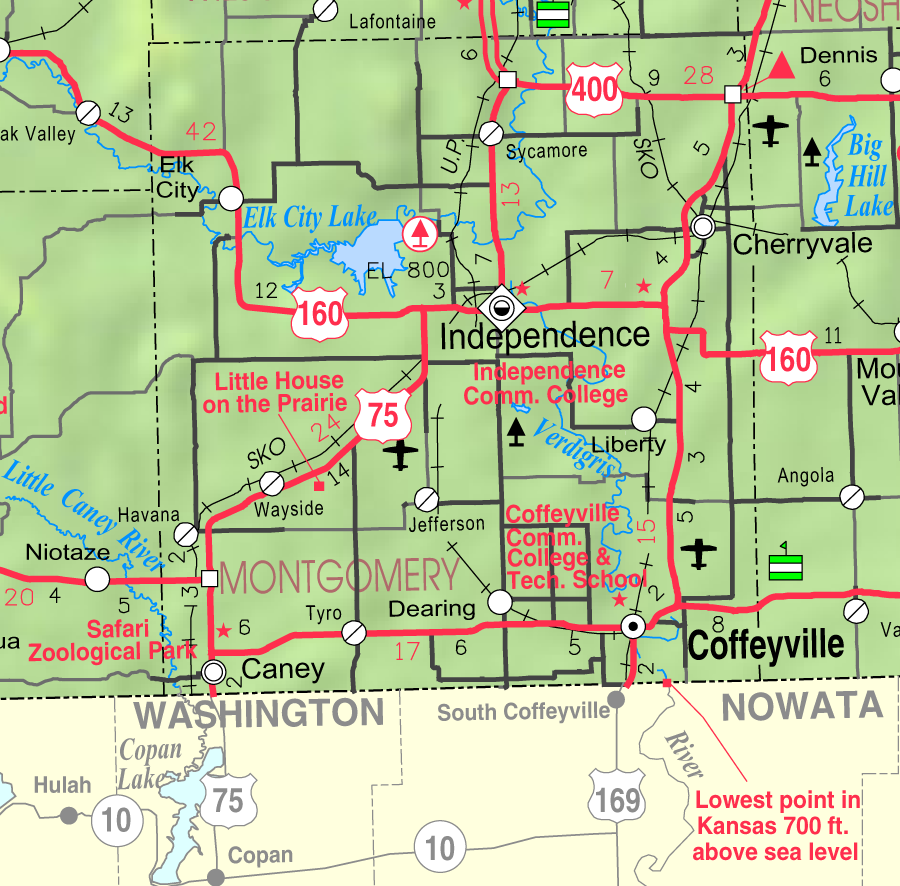
Size of this preview: 609 × 600 pixels. Other resolutions: 244 × 240 pixels | 488 × 480 pixels | 900 × 886 pixels.
Original file (900 × 886 pixels, file size: 350 KB, MIME type: image/png)
This is a file from the Wikimedia Commons and may be used by other projects. Information from its description page there is shown below. Commons is a freely licensed media file repository. |
Summary
| Description | This map of Montgomery County, Kansas, USA, is copied at a resolution of 300 pixels/inch from the original PDF file. |
| Date | |
| Source | Kansas 2005–2006 Official Transportation Map [1] (map legend) |
| Author | Designed and published by the Kansas Department of Transportation. |
| Permission (Reusing this file) |
|
Licensing
| This work has been released into the public domain by its author, Kansas Department of Transportation. This applies worldwide. In some countries this may not be legally possible; if so: Kansas Department of Transportation grants anyone the right to use this work for any purpose, without any conditions, unless such conditions are required by law.
|
This map is published by the Kansas Department of Transportation and is distributed to the public free of charge. KDOT makes no warranties, guarantees, or representations for accuracy of this information and assumes no liability for errors or omissions. Maps produced using tax payer dollars are free for public use.
File history
Click on a date/time to view the file as it appeared at that time.
| Date/Time | Thumbnail | Dimensions | User | Comment | |
|---|---|---|---|---|---|
| current | 03:20, 3 April 2006 | | 900 × 886 (350 KB) | Moverton | Source: Kansas 2005-2006 Official Transportation Map {{PD-US}} |
File usage
There are no pages that use this file.
Global file usage
The following other wikis use this file:
- Usage on azb.wikipedia.org
- Usage on en.wikipedia.org
- Usage on fa.wikipedia.org
- Usage on glk.wikipedia.org
- Usage on ja.wikipedia.org
- Usage on nl.wikipedia.org
- Usage on ru.wikipedia.org
- Usage on simple.wikipedia.org
- Usage on ur.wikipedia.org
- Usage on www.wikidata.org
- Usage on zh.wikipedia.org
Explore the world

United states
New York

Japan
Tokyo

Singapore
Singapore
