
 Français
 Italiano
Size of this PNG preview of this SVG file: 684 × 599 pixels. Other resolutions: 274 × 240 pixels | 548 × 480 pixels | 876 × 768 pixels | 1,168 × 1,024 pixels | 2,337 × 2,048 pixels | 809 × 709 pixels.
Original file (SVG file, nominally 809 × 709 pixels, file size: 484 KB)
This is a file from the Wikimedia Commons and may be used by other projects. Information from its description page there is shown below. Commons is a freely licensed media file repository. |
.svg)
Summary
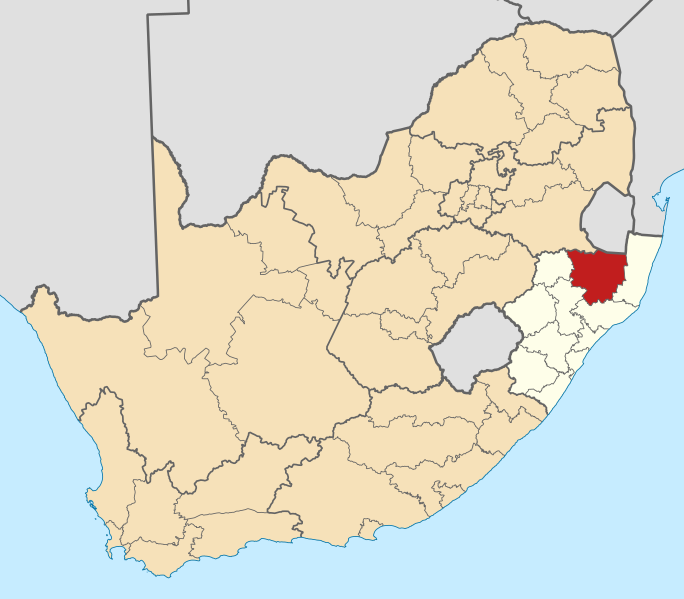
| Description | English: Map of district boundaries in South Africa, as they will be after the municipal elections of 18 May 2011, with the Zululand District Municipality highlighted in red within KwaZulu-Natal in yellow. |
| Date | |
| Source | Own work |
| Author | Htonl |
Licensing
I, the copyright holder of this work, hereby publish it under the following licenses:
 | Permission is granted to copy, distribute and/or modify this document under the terms of the GNU Free Documentation License, Version 1.2 or any later version published by the Free Software Foundation; with no Invariant Sections, no Front-Cover Texts, and no Back-Cover Texts. A copy of the license is included in the section entitled GNU Free Documentation License. |
This file is licensed under the Creative Commons Attribution-Share Alike 4.0 International, 3.0 Unported, 2.5 Generic, 2.0 Generic and 1.0 Generic license.
- You are free:
- to share – to copy, distribute and transmit the work
- to remix – to adapt the work
- Under the following conditions:
- attribution – You must give appropriate credit, provide a link to the license, and indicate if changes were made. You may do so in any reasonable manner, but not in any way that suggests the licensor endorses you or your use.
- share alike – If you remix, transform, or build upon the material, you must distribute your contributions under the same or compatible license as the original.
You may select the license of your choice.
File history
Click on a date/time to view the file as it appeared at that time.
| Date/Time | Thumbnail | Dimensions | User | Comment | |
|---|---|---|---|---|---|
| current | 20:02, 13 May 2011 | | 809 × 709 (484 KB) | Htonl | == Summary == {{Information |Description ={{en|1=Map of district boundaries in South Africa, as they will be after the municipal elections of 18 May 2011, with the w:Zululand District Municipality highl |
File usage
There are no pages that use this file.
Global file usage
The following other wikis use this file:
- Usage on af.wikipedia.org
- Vryheid, KwaZulu-Natal
- Louwsburg
- Mahlabatini
- Nongoma
- Ulundi
- Paulpietersburg
- Pongola
- Golela
- Glückstad
- Lüneberg
- Babanango
- Sjabloonbespreking:Suid-Afrikaanse distriksmunisipaliteit navbox
- Ceza, KwaZulu-Natal
- Tamboekiesdraai
- Pivaanspoort
- Belgrade, KwaZulu-Natal
- Blinkwater
- Eersteling
- Ncotshane
- Mondlo
- Hlobane
- Usage on en.wikipedia.org
- Ulundi
- Nongoma
- Babanango
- Paulpietersburg
- Vryheid
- Louwsburg
- Pongola, KwaZulu-Natal
- Mahlabatini
- Zululand District Municipality
- Template:Zululand District Municipality
- Kambula
- Abaqulusi Local Municipality
- Nongoma Local Municipality
- UPhongolo Local Municipality
- Golela
- Hlobane
- Ntabamhlophe
- Mondlo
- Ncotshane
- Belgrade, KwaZulu-Natal
- Eersteling
- Tamboekiesdraai
- Ceza, KwaZulu-Natal
- Lüneburg, KwaZulu-Natal
- Dingaanstat
- Glückstadt, KwaZulu-Natal
- Blinkwater, KwaZulu-Natal
- Pivaanspoort
- User:GerardM/Districts of South Africa
View more global usage of this file.
.svg)
.svg)
Explore the world

United states
New York

Japan
Tokyo

Singapore
Singapore
