
 Français
 Italiano
Size of this PNG preview of this SVG file: 646 × 600 pixels. Other resolutions: 258 × 240 pixels | 517 × 480 pixels | 827 × 768 pixels | 1,103 × 1,024 pixels | 2,206 × 2,048 pixels | 700 × 650 pixels.
Original file (SVG file, nominally 700 × 650 pixels, file size: 246 KB)
This is a file from the Wikimedia Commons and may be used by other projects. Information from its description page there is shown below. Commons is a freely licensed media file repository. |
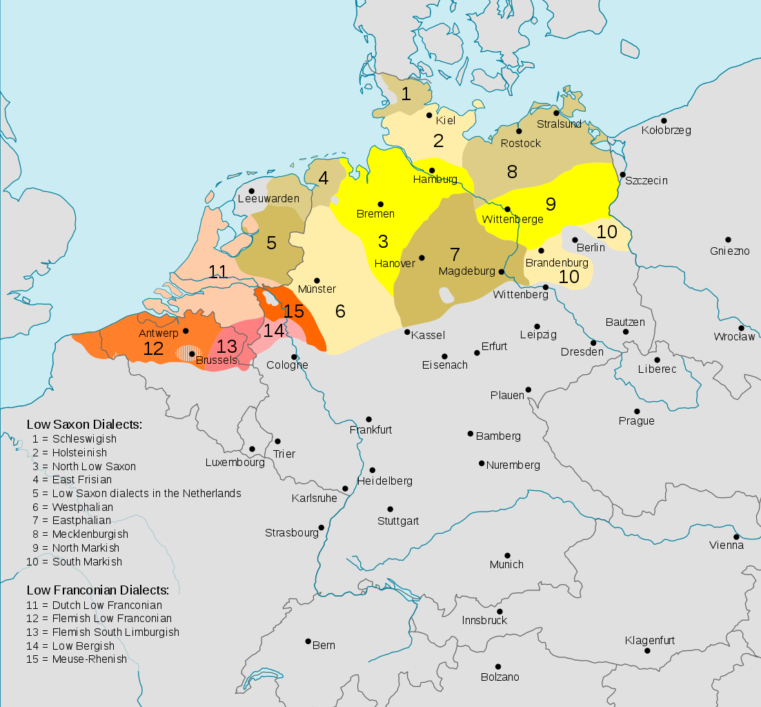
| Description | Deutsch: Darstellungskarte der niederdeutschen Mundarten (im weiteren Sinne) seit 1945 English: Distribution map of the Low German (Low Franconian and Low Saxon) languages since 1945. Note however that it's bad:
|
| Date | (UTC) |
| Source | |
| Author |
|
| Other versions | Cropped version without key
|


.svg)

This file is licensed under the Creative Commons Attribution-Share Alike 3.0 Unported license.
- You are free:
- to share – to copy, distribute and transmit the work
- to remix – to adapt the work
- Under the following conditions:
- attribution – You must give appropriate credit, provide a link to the license, and indicate if changes were made. You may do so in any reasonable manner, but not in any way that suggests the licensor endorses you or your use.
- share alike – If you remix, transform, or build upon the material, you must distribute your contributions under the same or compatible license as the original.
Original upload log
This image is a derivative work of the following images:
- File:Verbreitungsgebiet_der_heutigen_niederdeutschen_Mundarten.PNG licensed with PD-user-de, PD-user-w
- 2008-08-08T10:33:32Z Gruna 1 652x652 (37059 Bytes) See previous version
- 2006-04-14T17:48:45Z Vonvon 652x652 (36806 Bytes) * created on de.wikipedia.org by [[:de:Benutzer:Postmann Michael]] on 31 December 2004 * Beschreibung:Darstellungskarte der niederdeutschen Mundarten seit 1945 (''Location Map of the Low Germanic languages'') * original licen
- File:Europe.svg licensed with PD-USGov-CIA-WF
Uploaded with derivativeFX
File history
Click on a date/time to view the file as it appeared at that time.
| Date/Time | Thumbnail | Dimensions | User | Comment | |
|---|---|---|---|---|---|
| current | 18:54, 11 December 2017 | | 700 × 650 (246 KB) | Alphathon | Border in Lake Geneva and the Rhine delta |
| 18:24, 11 December 2017 |  | 700 × 650 (245 KB) | Alphathon | Corrected some settlement placements and Anglicised names | |
| 17:04, 11 December 2017 |  | 700 × 650 (245 KB) | Alphathon | Correction (Holland → the Netherlands) | |
| 21:54, 27 October 2015 |  | 700 × 650 (266 KB) | Alphathon | Corrected some minor errors and cropped | |
| 14:30, 7 February 2011 |  | 789 × 852 (292 KB) | Alphathon | Missed some in previous edit | |
| 14:29, 7 February 2011 |  | 789 × 852 (292 KB) | Alphathon | Minor font change (so it renders properly in previews etc.) | |
| 14:14, 7 February 2011 |  | 789 × 852 (290 KB) | Alphathon | Translated into English since it has an English title. German Version will be re-uploaded under a different name | |
| 01:15, 7 February 2011 |  | 789 × 852 (285 KB) | Alphathon | {{Information |Description={{de|Darstellungskarte der niederdeutschen Mundarten seit 1945}} {{en|Distribution map of the Low Saxon and Low Franconian languages since 1945}} |Source=*File:Verbreitungsgebiet_der_heutigen_niederdeutschen_Mundarten.PNG |
File usage
The following page uses this file:
Global file usage
The following other wikis use this file:
- Usage on an.wikipedia.org
- Usage on ar.wikipedia.org
- Usage on en.wikipedia.org
- Usage on nds-nl.wikipedia.org
- Usage on nl.wikipedia.org
- Usage on ru.wikipedia.org
- Usage on simple.wikipedia.org
- Usage on zh.wikivoyage.org
Metadata
Explore the world

United states
New York

Japan
Tokyo

Singapore
Singapore
