
 Français
 Italiano
Size of this preview: 481 × 599 pixels. Other resolutions: 193 × 240 pixels | 385 × 480 pixels | 616 × 768 pixels | 822 × 1,024 pixels | 2,175 × 2,710 pixels.
Original file (2,175 × 2,710 pixels, file size: 386 KB, MIME type: image/jpeg)
This is a file from the Wikimedia Commons and may be used by other projects. Information from its description page there is shown below. Commons is a freely licensed media file repository. |
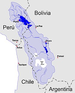
| Description | Español: Mapa de las dos principales cuencas endorréicas de la Meseta del Collao. El sistema; Lago Titicaca - Río Desaguadero - Lago Poopó - Salar de Coipasa. Y la cuenca del Salar de Uyuni | ||
| Date | |||
| Source | Own work | ||
| Author | Sayri | ||
| Permission (Reusing this file) |
|
 | This map image could be re-created using vector graphics as an SVG file. This has several advantages; see Commons:Media for cleanup for more information. If an SVG form of this image is available, please upload it and afterwards replace this template with {{vector version available|new image name}}.It is recommended to name the SVG file “Mapa cuencas endorréicas meseta del collao.svg”—then the template Vector version available (or Vva) does not need the new image name parameter. |


File history
Click on a date/time to view the file as it appeared at that time.
| Date/Time | Thumbnail | Dimensions | User | Comment | |
|---|---|---|---|---|---|
| current | 01:50, 18 April 2010 | | 2,175 × 2,710 (386 KB) | Sayri | {{Information |Description={{es|1=Mapa de las dos principales cuencas endorréicas de la Meseta del Collao. El sistema; Lago Titicaca - Río Desaguadero - Lago Poopó - Salar de Coipasa. Y la cuenca del Salar de Uyuni}} |Source={{own}} |Author=[[User:Sayr |
File usage
There are no pages that use this file.
Global file usage
The following other wikis use this file:
- Usage on am.wikipedia.org
- Usage on ay.wikipedia.org
- Usage on bcl.wikipedia.org
- Usage on bg.wikipedia.org
- Usage on en.wikipedia.org
- Usage on eo.wikipedia.org
- Usage on es.wikipedia.org
- Usage on fi.wikipedia.org
- Usage on fr.wikipedia.org
- Usage on id.wikipedia.org
- Usage on incubator.wikimedia.org
- Usage on it.wikipedia.org
- Usage on ja.wikipedia.org
- Usage on la.wikipedia.org
- Usage on lfn.wikipedia.org
- Usage on lt.wikipedia.org
- Usage on pt.wikipedia.org
- Usage on qu.wikipedia.org
- Usage on ru.wikipedia.org
- Usage on sh.wikipedia.org
- Usage on simple.wikipedia.org
- Usage on sr.wikipedia.org
- Usage on ur.wikipedia.org
- Usage on uz.wikipedia.org
Metadata
Explore the world

United states
New York

Japan
Tokyo

Singapore
Singapore
