
 Français
 Italiano
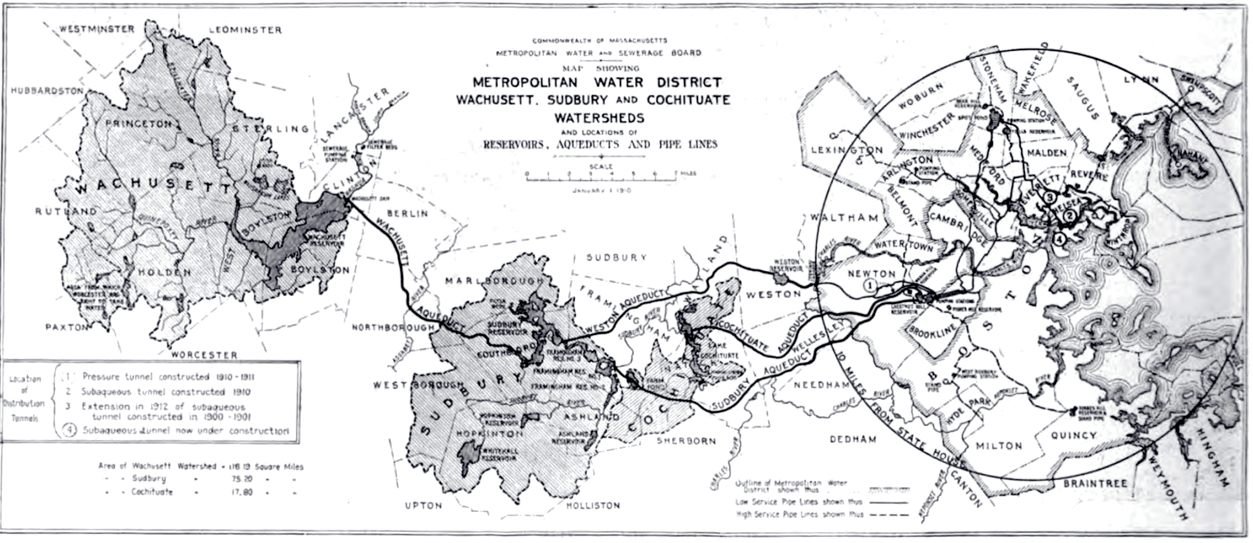
Size of this preview: 800 × 347 pixels. Other resolutions: 320 × 139 pixels | 640 × 278 pixels | 1,024 × 444 pixels | 1,280 × 555 pixels | 2,571 × 1,115 pixels.
Original file (2,571 × 1,115 pixels, file size: 1.26 MB, MIME type: image/jpeg)
This is a file from the Wikimedia Commons and may be used by other projects. Information from its description page there is shown below. Commons is a freely licensed media file repository. |
.jpg)
Summary
| Description | 1910 map of the Metropolitan Water District system, Metropolitan Water & Sewage Board (Boston area), Commonwealth of Massachusetts, USA. |
| Date | Published July 22, 1914. Map prepared as of January 1, 1910. |
| Source | Halbert Powers Gillette, "Engineering & contracting", Vol. XLII, No. 4, Page 84. |
| Author | Metropolitan Water & Sewage Board, Commonwealth of Massachusetts. |
| Permission (Reusing this file) | Public domain - first published in the United States before 1923. |
Licensing
This media file is in the public domain in the United States. This applies to U.S. works where the copyright has expired, often because its first publication occurred prior to January 1, 1930, and if not then due to lack of notice or renewal. See this page for further explanation. |  | |
 |
File history
Click on a date/time to view the file as it appeared at that time.
| Date/Time | Thumbnail | Dimensions | User | Comment | |
|---|---|---|---|---|---|
| current | 19:33, 14 August 2010 | | 2,571 × 1,115 (1.26 MB) | Daderot | {{Information |Description=1910 map of the Metropolitan Water District system, Metropolitan Water & Sewage Board (Boston area), Commonwealth of Massachusetts, USA. |Source=Halbert Powers Gillette, "Engineering & contracting", Vol. XLII, No. 4, Page 84. | |
File usage
There are no pages that use this file.
Global file usage
The following other wikis use this file:
- Usage on ceb.wikipedia.org
- Usage on en.wikipedia.org
- Usage on www.wikidata.org
Metadata
.jpg)
Explore the world

United states
New York

Japan
Tokyo

Singapore
Singapore
