
 Français
 Italiano
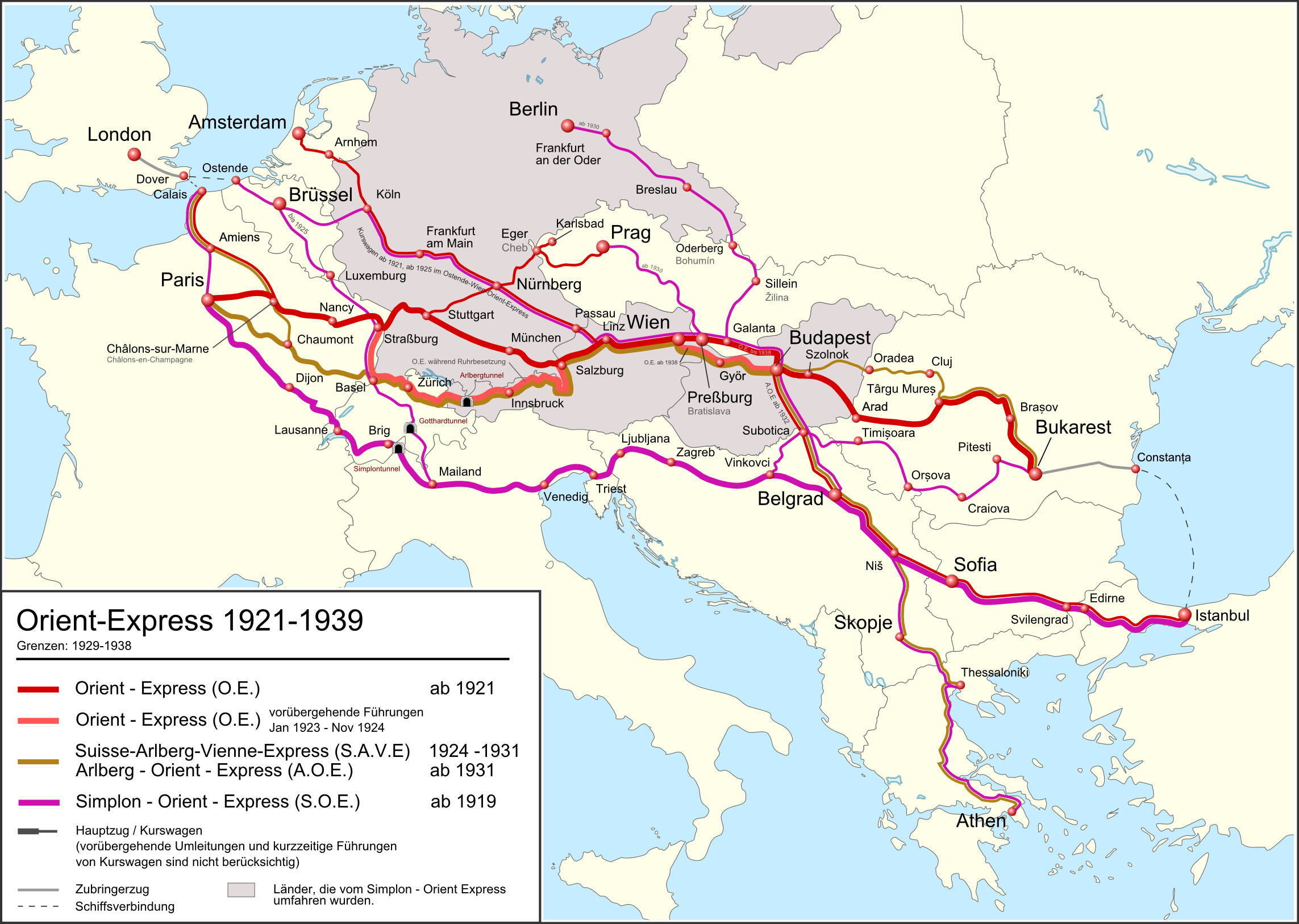
Size of this preview: 800 × 569 pixels. Other resolutions: 320 × 228 pixels | 640 × 455 pixels | 1,024 × 728 pixels | 1,280 × 910 pixels | 2,286 × 1,626 pixels.
Original file (2,286 × 1,626 pixels, file size: 988 KB, MIME type: image/png)
This is a file from the Wikimedia Commons and may be used by other projects. Information from its description page there is shown below. Commons is a freely licensed media file repository. |
Summary
| Description | Deutsch: Karte des Orient Express Züge von 1921 bis 1939. Landesgrenzen auf dem Stand 1929-1938. English: Route of the Orient Express Trains from 1921 to 1939. National borders as per 1929-1938. Français : Carte des trajets de l'Orient Express de 1921 à 1939. Frontier de 1929 à 1938. |
| Date | 25 February 2012 00:16 (UTC) |
| Source | This file was derived from: |
| Author |
|
| Other versions |
|


Licensing
This file is licensed under the Creative Commons Attribution-Share Alike 3.0 Unported license.
- You are free:
- to share – to copy, distribute and transmit the work
- to remix – to adapt the work
- Under the following conditions:
- attribution – You must give appropriate credit, provide a link to the license, and indicate if changes were made. You may do so in any reasonable manner, but not in any way that suggests the licensor endorses you or your use.
- share alike – If you remix, transform, or build upon the material, you must distribute your contributions under the same or compatible license as the original.
Original upload log
This image is a derivative work of the following images:
- File:Orient-Express_1919-1939-2.png licensed with Cc-by-sa-3.0
- 2012-02-20T18:53:59Z Pechristener 2285x1626 (861891 Bytes) Dateifehler behoben
- 2012-02-20T18:48:24Z Pechristener 2285x1626 (859174 Bytes) == {{int:filedesc}} == {{Information |Description=*{{en}}Route of the Orient Express Trains from 1919 to 1939. National borders as per 1929-1938 *{{de}}Karte des Orient Express Züge von 1919 bis 1939. Landesgrenzen auf dem S
File history
Click on a date/time to view the file as it appeared at that time.
| Date/Time | Thumbnail | Dimensions | User | Comment | |
|---|---|---|---|---|---|
| current | 07:29, 3 January 2018 | | 2,286 × 1,626 (988 KB) | Pechristener | korr Constanţa |
| 01:29, 30 January 2014 |  | 2,284 × 1,624 (668 KB) | Kopiersperre | optipng | |
| 00:54, 9 March 2012 |  | 2,284 × 1,624 (990 KB) | Pechristener | Streckenführung in Rumänien | |
| 00:32, 9 March 2012 |  | 2,285 × 1,626 (981 KB) | Pechristener | Kurswagen von Amsterdam / Streckenführung in Rumänien | |
| 20:24, 26 February 2012 |  | 2,284 × 1,624 (977 KB) | Pechristener | fehlende Städtenamen ergänzt / Bemerkung in der Legende / Grösse der Städtenamen | |
| 14:56, 26 February 2012 |  | 2,285 × 1,626 (948 KB) | Pechristener | finale Version noch nicht von de:User:Wahldresdner kontrolliert | |
| 00:16, 25 February 2012 |  | 2,285 × 1,626 (902 KB) | Pechristener | == {{int:filedesc}} == {{Information |Description={{en}}Route of the Orient Express Trains from 1921 to 1939. National borders as per 1929-1938 (not yet finisched) {{de}}Karte des Orient Express Züge von 1921 bis 1939. Landesgrenzen auf dem Stand 1929... |
File usage
The following page uses this file:
Global file usage
The following other wikis use this file:
- Usage on ar.wikipedia.org
- Usage on de.wikipedia.org
- Usage on fr.wikipedia.org
- Usage on it.wikipedia.org
- Usage on ja.wikipedia.org
- Usage on www.wikidata.org
- Usage on zh.wikivoyage.org
Metadata
Explore the world

United states
New York

Japan
Tokyo

Singapore
Singapore
