
 Français
 Italiano
Size of this preview: 592 × 599 pixels. Other resolutions: 237 × 240 pixels | 474 × 480 pixels | 952 × 964 pixels.
Original file (952 × 964 pixels, file size: 136 KB, MIME type: image/png)
This is a file from the Wikimedia Commons and may be used by other projects. Information from its description page there is shown below. Commons is a freely licensed media file repository. |
Summary
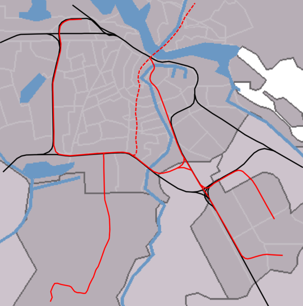
| Description | outline map Amsterdam metro/railways |
| Date | |
| Source | self-made, background based on Image:Map NL - Amsterdam - .png, see also image:Outline_map_Amsterdam_metro_2.PNG for version without North/South line |
| Author | Michiel1972 |
Licensing
| I, the copyright holder of this work, release this work into the public domain. This applies worldwide. In some countries this may not be legally possible; if so: I grant anyone the right to use this work for any purpose, without any conditions, unless such conditions are required by law. |
 | The copyright holder of this file, Centraal Bureau voor de Statistiek, allows anyone to use it for any purpose, provided that the copyright holder is properly attributed. Redistribution, derivative work, commercial use, and all other use is permitted. |
Attribution:
|
File history
Click on a date/time to view the file as it appeared at that time.
| Date/Time | Thumbnail | Dimensions | User | Comment | |
|---|---|---|---|---|---|
| current | 14:45, 11 August 2007 | | 952 × 964 (136 KB) | Michiel1972 | == Summary == {{Information |Description=outline map Amsterdam metro/railways |Source=self-made, background based on Image:Map NL - Amsterdam - .png, see also image:Outline_map_Amsterdam_metro_2.PNG for version without North/South line |Date=aug |
File usage
There are no pages that use this file.
Global file usage
The following other wikis use this file:
- Usage on ar.wikipedia.org
- Usage on ca.wikipedia.org
- Usage on ceb.wikipedia.org
- Usage on en.wikipedia.org
- Amsterdam Zuid station
- Amsterdam Centraal station
- Module:Location map/data/Netherlands Amsterdam metro station/doc
- Amsterdam RAI station
- Amsterdam Lelylaan station
- De Vlugtlaan metro station
- Henk Sneevlietweg metro station
- Jan van Galenstraat metro station
- Amstelveenseweg metro station
- Noord metro station
- Heemstedestraat metro station
- Postjesweg metro station
- De Boelelaan/VU tram stop
- Van Boshuizenstraat tram stop
- Kronenburg tram stop
- Zonnestein tram stop
- Onderuit tram stop
- Oranjebaan tram stop
- Amstelveen Centrum tram stop
- Marne tram stop
- Gondel tram stop
- Uilenstede tram stop
- Module:Location map/data/Netherlands Amsterdam metro station
- De Pijp metro station
- Vijzelgracht metro station
- Europaplein metro station
- Rokin metro station
- Noorderpark metro station
- Usage on eo.wikipedia.org
- Greenpeace
- Gein (amsterdama metrostacio)
- Isolatorweg (amsterdama metrostacio)
- Westwijk (amsterdama metrostacio)
- Gaasperplas (amsterdama metrostacio)
- Noord (amsterdama metrostacio)
- Nieuwmarkt (amsterdama metrostacio)
- Waterlooplein (amsterdama metrostacio)
- Weesperplein (amsterdama metrostacio)
- Wibautstraat (amsterdama metrostacio)
- Spaklerweg (amsterdama metrostacio)
- Van der Madeweg (amsterdama metrostacio)
- Overamstel (amsterdama metrostacio)
- Bullewijk (amsterdama metrostacio)
- Reigersbos (amsterdama metrostacio)
- Strandvliet (amsterdama metrostacio)
- De Boelelaan/VU (amsterdama metrostacio)
- A.J. Ernststraat (amsterdama metrostacio)
- Van Boshuizenstraat (amsterdama metrostacio)
View more global usage of this file.
Metadata
Explore the world

United states
New York

Japan
Tokyo

Singapore
Singapore
