
 Français
 Italiano
Size of this preview: 569 × 599 pixels. Other resolutions: 228 × 240 pixels | 456 × 480 pixels | 729 × 768 pixels | 973 × 1,024 pixels | 1,930 × 2,032 pixels.
Original file (1,930 × 2,032 pixels, file size: 412 KB, MIME type: image/png)
This is a file from the Wikimedia Commons and may be used by other projects. Information from its description page there is shown below. Commons is a freely licensed media file repository. |
 | This map image could be re-created using vector graphics as an SVG file. This has several advantages; see Commons:Media for cleanup for more information. If an SVG form of this image is available, please upload it and afterwards replace this template with {{vector version available|new image name}}.It is recommended to name the SVG file “Pacific Northwest River System.svg”—then the template Vector version available (or Vva) does not need the new image name parameter. |
Summary
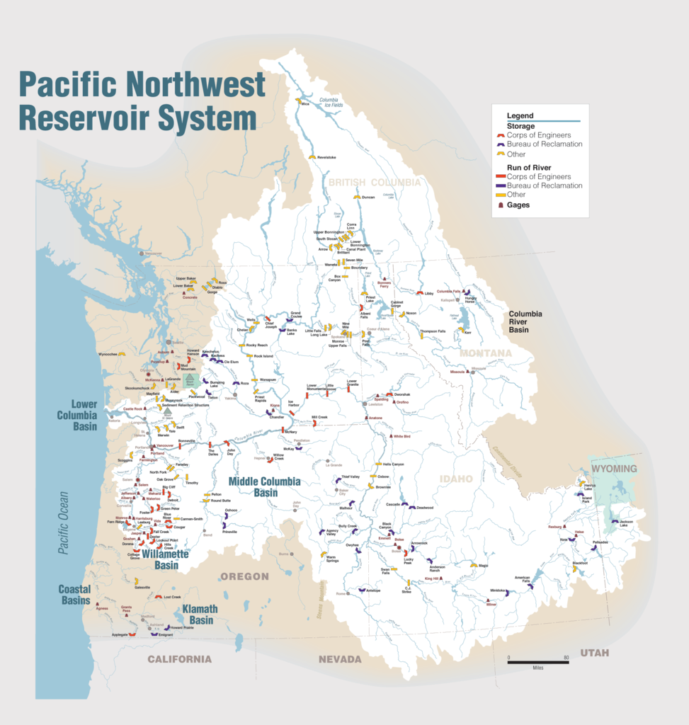
| Description | English: Maps of dams, drainage and estuaries along the Columbia River in North America (USA, Canada). Original caption: The Columbia River carved the Interior Columbia River Basin from the landscape of seven Western states and two Canadian provinces. The river itself flows from its headwaters in British Columbia, Canada through only two states, forming part of the Washington-Oregon border, the vast Interior Columbia River Basin is defined by the area drained by the river and its many tributaries. This 58-million-hectare area (about the size of France) extends roughly from the crest of the Cascade Mountains of Oregon and Washington east through Idaho to the Continental Divide in the Rocky Mountains of Montana and Wyoming, and from the headwaters of the Columbia River in Canada to the high desert of northern Nevada and northwestern Utah. |
| Date | |
| Source | Portland District Visual Information, U.S. Army Corps of Engineers |
| Author | U.S. Army Corps of Engineers |
| Other versions | Derivative works of this file: Columbia.png |
Licensing
This image or file is a work of a U.S. Army Corps of Engineers soldier or employee, taken or made as part of that person's official duties. As a work of the U.S. federal government, the image is in the public domain.
|
File history
Click on a date/time to view the file as it appeared at that time.
| Date/Time | Thumbnail | Dimensions | User | Comment | |
|---|---|---|---|---|---|
| current | 22:31, 11 January 2010 | | 1,930 × 2,032 (412 KB) | Spankston | larger file, higher resolution |
| 21:56, 11 January 2010 |  | 914 × 963 (565 KB) | Spankston | {{Information |Description={{en|1=Maps of dams, drainage and estuaries along the Columbia River in North America (USA, Canada). Original caption: The Columbia River carved the Interior Columbia River Basin from the landscape of seven Western states a |
File usage
There are no pages that use this file.
Global file usage
The following other wikis use this file:
- Usage on bg.wikipedia.org
- Usage on de.wikipedia.org
- Usage on en.wikipedia.org
- Rocky Reach Dam
- Rock Island Dam
- Wanapum Dam
- Priest Rapids Dam
- Bonneville Dam
- Salmon River (Idaho)
- List of rivers of Washington (state)
- List of dams in the Columbia River watershed
- Revelstoke Dam
- The Dalles Dam
- Keenleyside Dam
- Columbia River Treaty
- Little Goose Dam
- Lower Granite Dam
- Lower Monumental Dam
- Ice Harbor Dam
- Dworshak Dam
- Palisades Dam
- Hells Canyon Dam
- Oxbow Dam
- Brownlee Dam
- Jackson Lake Dam
- C. J. Strike Dam
- Lake Cascade
- Deadwood Reservoir
- Lucky Peak Dam
- Arrowrock Dam
- Anderson Ranch Dam
- Zosel Dam
- Usage on fi.wikipedia.org
- Usage on fr.wikipedia.org
- Usage on fy.wikipedia.org
- Usage on he.wikipedia.org
- Usage on it.wikipedia.org
- Usage on nl.wikipedia.org
- Usage on no.wikipedia.org
View more global usage of this file.
Explore the world

United states
New York

Japan
Tokyo

Singapore
Singapore
