
 Français
 Italiano
Size of this PNG preview of this SVG file: 800 × 600 pixels. Other resolutions: 320 × 240 pixels | 640 × 480 pixels | 1,024 × 768 pixels | 1,280 × 960 pixels | 2,560 × 1,920 pixels.
Original file (SVG file, nominally 1,024 × 768 pixels, file size: 1,002 KB)
This is a file from the Wikimedia Commons and may be used by other projects. Information from its description page there is shown below. Commons is a freely licensed media file repository. |
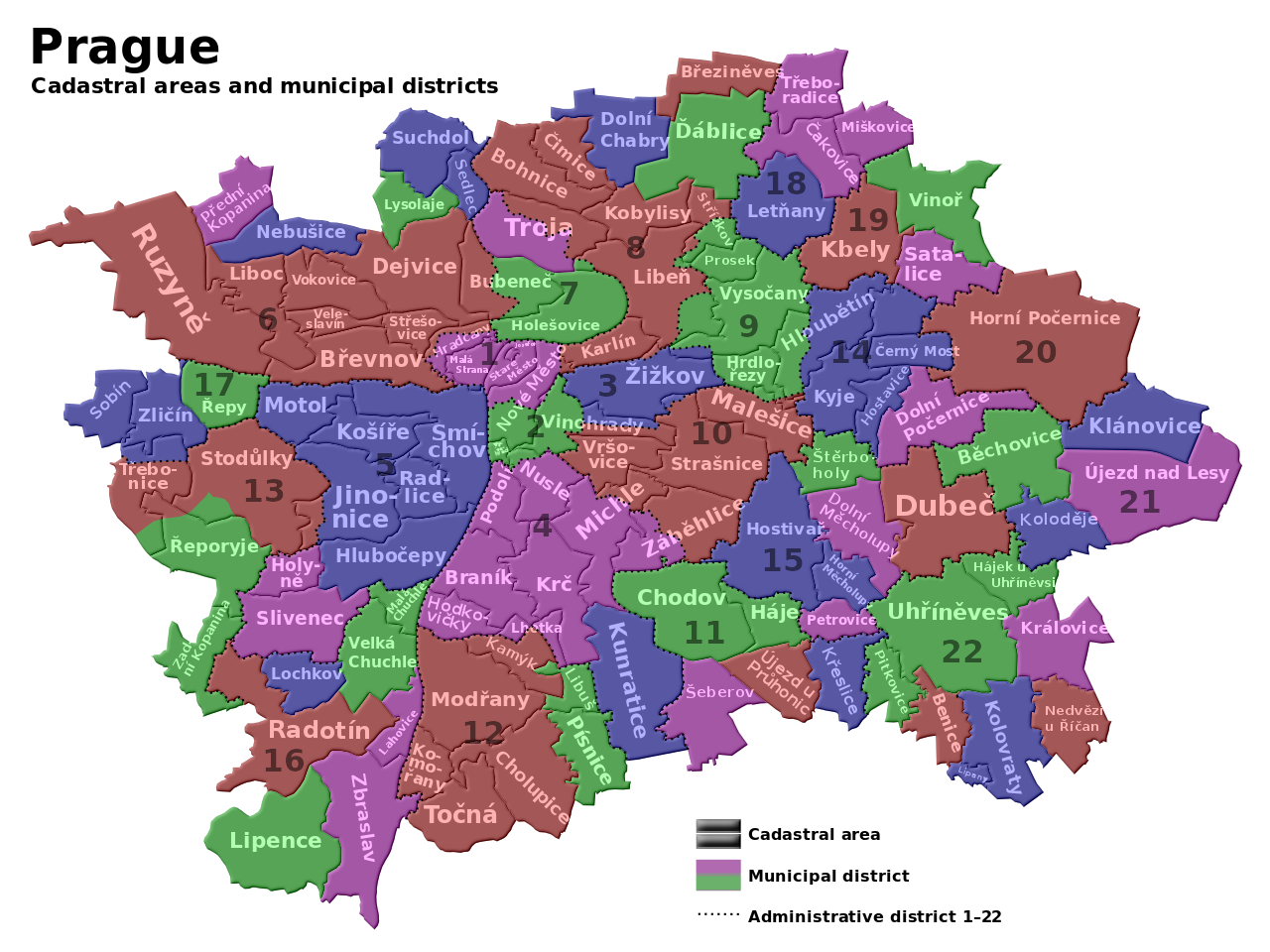
| Description | English: Maps of Prague cadastre and administratice districts Čeština: Mapa pražských katastrálních území a městských částí |
| Date | (UTC) |
| Source | |
| Author |
|
| This is a retouched picture, which means that it has been digitally altered from its original version. Modifications: legend translated into English. The original can be viewed here: Prague districts.svg:
|
I, the copyright holder of this work, hereby publish it under the following licenses:
This file is licensed under the Creative Commons Attribution-Share Alike 3.0 Unported license.
- You are free:
- to share – to copy, distribute and transmit the work
- to remix – to adapt the work
- Under the following conditions:
- attribution – You must give appropriate credit, provide a link to the license, and indicate if changes were made. You may do so in any reasonable manner, but not in any way that suggests the licensor endorses you or your use.
- share alike – If you remix, transform, or build upon the material, you must distribute your contributions under the same or compatible license as the original.
 | Permission is granted to copy, distribute and/or modify this document under the terms of the GNU Free Documentation License, Version 1.2 or any later version published by the Free Software Foundation; with no Invariant Sections, no Front-Cover Texts, and no Back-Cover Texts. A copy of the license is included in the section entitled GNU Free Documentation License. |
You may select the license of your choice.
Original upload log
This image is a derivative work of the following images:
- File:Prague_districts.svg licensed with Cc-by-sa-3.0, GFDL
- 2009-05-09T12:09:00Z Kubiik 1024x768 (1026372 Bytes) Troja is separated part
- 2009-03-09T09:37:00Z Kubiik 1024x768 (1026361 Bytes) More accurate and shadow borders
- 2009-02-05T12:37:28Z Kubiik 1313x990 (905164 Bytes) {{Information |Description={{en|1=Maps of Prague cadastre and administratice districts}} {{cs|1=Mapa pražských katastrálních území a městských částí}} |Source=Own work by uploader |Author=[[User:Kubiik|Kubiik]] |Da
Uploaded with derivativeFX
File history
Click on a date/time to view the file as it appeared at that time.
| Date/Time | Thumbnail | Dimensions | User | Comment | |
|---|---|---|---|---|---|
| current | 14:54, 11 May 2009 | | 1,024 × 768 (1,002 KB) | DavidSpanel | {{Information |Description={{en|1=Maps of Prague cadastre and administratice districts}} {{cs|1=Mapa pražských katastrálních území a městských částí}} |Source=*File:Prague_districts.svg |Date=2009-05-11 15:53 (UTC) |Author=*[[:File:Prague |
File usage
There are no pages that use this file.
Global file usage
The following other wikis use this file:
- Usage on an.wikipedia.org
- Usage on ar.wikipedia.org
- Usage on azb.wikipedia.org
- Usage on ceb.wikipedia.org
- Usage on en.wikipedia.org
- Usage on es.wikipedia.org
- Usage on fa.wikipedia.org
- Usage on fr.wikipedia.org
- Usage on hu.wikipedia.org
- Usage on si.wikipedia.org
- Usage on uk.wikipedia.org
- Usage on uz.wikipedia.org
- Usage on war.wikipedia.org
Explore the world

United states
New York

Japan
Tokyo

Singapore
Singapore
