
 Français
 Italiano
Size of this preview: 800 × 583 pixels. Other resolutions: 320 × 233 pixels | 640 × 467 pixels | 1,024 × 747 pixels | 1,280 × 933 pixels | 1,838 × 1,340 pixels.
Original file (1,838 × 1,340 pixels, file size: 901 KB, MIME type: image/jpeg)
This is a file from the Wikimedia Commons and may be used by other projects. Information from its description page there is shown below. Commons is a freely licensed media file repository. |
Summary
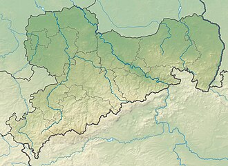
| Description | Deutsch: Physische Positionskarte Sachsen, Deutschland. Geographische Begrenzung der Karte: English: Physical Location map Saxony, Germany. Geographic limits of the map:
|
| Date | |
| Source | Own work |
| Author | Grundkarte TUBS, Relief Alexrk2 |
| Other versions |
|

Licensing
I, the copyright holder of this work, hereby publish it under the following licenses:
 | Permission is granted to copy, distribute and/or modify this document under the terms of the GNU Free Documentation License, Version 1.2 or any later version published by the Free Software Foundation; with no Invariant Sections, no Front-Cover Texts, and no Back-Cover Texts. A copy of the license is included in the section entitled GNU Free Documentation License. |
This file is licensed under the Creative Commons Attribution-Share Alike 3.0 Unported, 2.5 Generic, 2.0 Generic and 1.0 Generic license.
- You are free:
- to share – to copy, distribute and transmit the work
- to remix – to adapt the work
- Under the following conditions:
- attribution – You must give appropriate credit, provide a link to the license, and indicate if changes were made. You may do so in any reasonable manner, but not in any way that suggests the licensor endorses you or your use.
- share alike – If you remix, transform, or build upon the material, you must distribute your contributions under the same or compatible license as the original.
You may select the license of your choice.
File history
Click on a date/time to view the file as it appeared at that time.
| Date/Time | Thumbnail | Dimensions | User | Comment | |
|---|---|---|---|---|---|
| current | 20:36, 23 October 2009 | | 1,838 × 1,340 (901 KB) | Alexrk2 | == {{int:filedesc}} == {{Information |Description= {{de|Physische Positionskarte Sachsen, Deutschland. Geographische Begrenzung der Karte:}} {{en|Physical Location map Saxony, Germany. Geographic limits of the map:}} * N: |
File usage
There are no pages that use this file.
Global file usage
The following other wikis use this file:
- Usage on ar.wikipedia.org
- Usage on az.wikipedia.org
- Usage on ba.wikipedia.org
- Usage on be.wikipedia.org
- Usage on bg.wikipedia.org
- Лайпциг
- Дрезден
- Кемниц
- Цвикау
- Шлайфе
- Бауцен
- Гросботен
- Росвайн
- Валдхайм
- Делич
- Митвайда
- Ратен
- Гьорлиц
- Майсен
- Плауен
- Шаблон:ПК Германия Саксония
- Клингентал
- Лайпцигски университет
- Бад Мускау
- Бернщат на Айген
- Еберсбах-Нойгерсдорф
- Хернхут
- Льобау
- Нойзалца-Шпремберг
- Ниски
- Остриц
- Райхенбах (Горна Лужица)
- Ротенбург (Горна Лужица)
- Зайфхенерсдорф
- Вайсвасер
- Цитау
- Бернсдорф (окръг Бауцен)
- Бишофсверда
- Елстра
- Каменц
- Гросрьорсдорф
- Хойерсверда
- Кьонигсбрюк
- Лаута
- Пулшниц
- Радеберг
- Ширгисвалде-Киршау
- Вайсенберг
- Вилтен
- Витихенау
View more global usage of this file.
Metadata
Explore the world

United states
New York

Japan
Tokyo

Singapore
Singapore
