
 Français
 Italiano
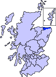
No higher resolution available.
ScotlandAberdeenshireBanffBuchan.png (191 × 261 pixels, file size: 4 KB, MIME type: image/png)
This is a file from the Wikimedia Commons and may be used by other projects. Information from its description page there is shown below. Commons is a freely licensed media file repository. |
Summary
| Description | Aberdeenshire unitary council - Banff and Buchan Area |
| Source | Slightly edited version of a map drawn by Morwen and Voyager |
| Author |
Licensing
I, the copyright holder of this work, hereby publish it under the following licenses:
 | Permission is granted to copy, distribute and/or modify this document under the terms of the GNU Free Documentation License, Version 1.2 or any later version published by the Free Software Foundation; with no Invariant Sections, no Front-Cover Texts, and no Back-Cover Texts. A copy of the license is included in the section entitled GNU Free Documentation License. |
| This file is licensed under the Creative Commons Attribution-Share Alike 3.0 Unported license. | ||
| ||
| This licensing tag was added to this file as part of the GFDL licensing update. |
You may select the license of your choice.
File history
Click on a date/time to view the file as it appeared at that time.
| Date/Time | Thumbnail | Dimensions | User | Comment | |
|---|---|---|---|---|---|
| current | 01:39, 8 November 2007 | | 191 × 261 (4 KB) | Harami2000 | == Summary == == Summary == {{Information |Description= Aberdeenshire unitary council - Banff and Buchan Area |Source= Slightly edited version of a map drawn by Morwen and Voyager |Date= |Author= |Permission= |ot |
File usage
There are no pages that use this file.
Global file usage
The following other wikis use this file:
- Usage on en.wikipedia.org
- Aberdeenshire
- Fraserburgh
- Portsoy
- Banff and Buchan
- Rosehearty
- Aberchirder
- Inverallochy and Cairnbulg
- Kinnaird Head
- Gardenstown
- Findlater Castle
- Pennan
- King Edward, Aberdeenshire
- Crovie
- New Aberdour
- Duff House
- Banff, Aberdeenshire
- Macduff, Aberdeenshire
- Cornhill, Aberdeenshire
- Sandend
- Broadsea
- Boyndie
- Template:Banff and Buchan, Aberdeenshire places
- Sandhaven
- Whitehills
- New Byth
- Fordyce, Aberdeenshire
- Netherbrae
- Memsie
- Cortes, Aberdeenshire
- Tyrie, Aberdeenshire
- Gordonstown, Banff and Buchan
- Rathen, Aberdeenshire
- Crudie
Explore the world

United states
New York

Japan
Tokyo

Singapore
Singapore
