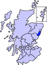
ScotlandAberdeenshireKincardineMearns.png (191 × 261 pixels, file size: 4 KB, MIME type: image/png)
File history
Click on a date/time to view the file as it appeared at that time.
| Date/Time | Thumbnail | Dimensions | User | Comment | |
|---|---|---|---|---|---|
| current | 22:58, 7 November 2007 |  | 191 × 261 (4 KB) | Harami2000 | == Summary == {{Information |Description= Aberdeenshire unitary council - Marr Area |Source= Slightly edited version of a map drawn by Morwen and Voyager |Date= |Author= |Permission= |other_versions= }} |
File usage
There are no pages that use this file.
Global file usage
The following other wikis use this file:
- Usage on en.wikipedia.org
- Aberdeenshire
- Stonehaven
- Dunnottar Castle
- Drum Castle
- Fettercairn
- Laurencekirk
- Kincardine and Mearns
- Inverbervie
- Maryculter
- Findon, Aberdeenshire
- Muchalls Castle
- Monboddo House
- Fetteresso Castle
- Portlethen
- Drumoak
- Johnshaven
- Newtonhill
- Arbuthnott
- Fowlsheugh
- Catterline
- St Cyrus
- Portlethen Moss
- Portlethen Village
- Raedykes
- Stonehaven Tolbooth
- Downies
- Drumlithie
- Glenbervie
- Tewel
- Fordoun
- The Den and the Glen
- Muchalls
- Gourdon, Aberdeenshire
- Kinneff
- Bridge of Muchalls
- Netherley, Aberdeenshire
- Causey Mounth
- Cammachmore
- Cookney
- Crawton
- Banchory-Devenick
- Auchenblae
- Normandykes
- Kirktown of Fetteresso
- Template:Kincardine and Mearns, Aberdeenshire places
- Craiglethy
- Marykirk
- Kirkton of Durris
- Stonehaven Open Air Pool
- Chapelton, Aberdeenshire
View more global usage of this file.


 Français
 Italiano


