
 Français
 Italiano
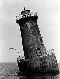
No higher resolution available.
Sharps-Island-Light.jpg (200 × 266 pixels, file size: 14 KB, MIME type: image/jpeg)
This is a file from the Wikimedia Commons and may be used by other projects. Information from its description page there is shown below. Commons is a freely licensed media file repository. |
Summary
| Description | Sharps Island Light, Chesapeake Bay, Maryland, USA. 38°38′20″N 76°22′34″W / 38.63897°N 76.37611°W
| ||
| Date | |||
| Source | http://www.cr.nps.gov/maritime/light/graphic/sharps.jpg | ||
| Author | Candace Clifford |
| Object location | | View this and other nearby images on: OpenStreetMap |
|---|
Licensing
| This image or media file contains material based on a work of a National Park Service employee, created as part of that person's official duties. As a work of the U.S. federal government, such work is in the public domain in the United States. See the NPS website and NPS copyright policy for more information. |
File history
Click on a date/time to view the file as it appeared at that time.
| Date/Time | Thumbnail | Dimensions | User | Comment | |
|---|---|---|---|---|---|
| current | 16:37, 11 January 2007 | | 200 × 266 (14 KB) | Eoghanacht | {{Information |Description= Sharps Island Light, Chesapeake Bay, Maryland, USA {{coor d|38.6382|N|76.3749|W|type:landmark}} |Source= http://www.cr.nps.gov/maritime/light/graphic/sharps.jpg |Date= 1977 |Author= Candace Clifford |Permission= {{w|National Pa |
File usage
There are no pages that use this file.
Global file usage
The following other wikis use this file:
- Usage on en.wikipedia.org
- Seven Foot Knoll Light
- User:Eoghanacht
- Thomas Point Shoal Light
- Triton Light
- Holland Island Bar Light
- Baltimore Harbor Light
- Point No Point Light (Maryland)
- Upper Cedar Point Light
- Mathias Point Light
- Blakistone Island Light
- Bodkin Island Light
- Piney Point Light
- Concord Point Light
- Craighill Channel Lower Range Front Light
- Sharps Island Light
- Sandy Point Shoal Light
- Point Lookout Light
- Turkey Point Light
- Fort Washington Light
- Solomons Lump Light
- Pooles Island Light
- Bloody Point Bar Light
- Fishing Battery Light
- Choptank River Light
- Somers Cove Light
- Maryland Point Light
- Ragged Point Light
- Cobb Point Bar Light
- Cove Point Light
- Hooper Island Light
- Sharkfin Shoal Light
- Fog Point Light
- Clay Island Light
- Greenbury Point Light
- Lower Cedar Point Light
- Love Point Light
- Great Shoals Light
- Drum Point Light
- Hooper Strait Light
- Cedar Point Light (Maryland)
- Janes Island Light
- Craighill Channel Lower Range Rear Light
- Fort Carroll Light
- Lazaretto Point Light
- Hawkins Point Light
- Craighill Channel Upper Range Rear Light
- Leading Point Light
- Craighill Channel Upper Range Front Light
- North Point Range Lights
- Template:Lighthouses of Maryland
View more global usage of this file.
Metadata
Explore the world

United states
New York

Japan
Tokyo

Singapore
Singapore
