
 Français
 Italiano
Size of this preview: 800 × 411 pixels. Other resolutions: 320 × 164 pixels | 640 × 329 pixels | 1,024 × 526 pixels | 1,500 × 771 pixels.
Original file (1,500 × 771 pixels, file size: 92 KB, MIME type: image/png)
This is a file from the Wikimedia Commons and may be used by other projects. Information from its description page there is shown below. Commons is a freely licensed media file repository. |
Summary
 | This map image could be re-created using vector graphics as an SVG file. This has several advantages; see Commons:Media for cleanup for more information. If an SVG form of this image is available, please upload it and afterwards replace this template with {{vector version available|new image name}}.It is recommended to name the SVG file “Spain and Portugal.svg”—then the template Vector version available (or Vva) does not need the new image name parameter. |
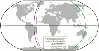
| Description | Colonial demarcation lines between Castille/Spain and Portugal in the 15th and 16th Centuries. (Treaty of Tordesillas and Treaty of Saragossa) |
| Date | |
| Source | Own work |
| Author | Lencer |
| Other versions |
|


 | This map has been made or improved in the German Kartenwerkstatt (Map Lab). You can propose maps to improve as well. |
Licensing
The map has been created with the Generic Mapping Tools: https://www.generic-mapping-tools.org/ using one or more of these public-domain datasets for the relief:
|
 | Permission is granted to copy, distribute and/or modify this document under the terms of the GNU Free Documentation License, Version 1.2 or any later version published by the Free Software Foundation; with no Invariant Sections, no Front-Cover Texts, and no Back-Cover Texts. A copy of the license is included in the section entitled GNU Free Documentation License. |
| This file is licensed under the Creative Commons Attribution-Share Alike 3.0 Unported license. | ||
| ||
| This licensing tag was added to this file as part of the GFDL licensing update. |
File history
Click on a date/time to view the file as it appeared at that time.
| Date/Time | Thumbnail | Dimensions | User | Comment | |
|---|---|---|---|---|---|
| current | 07:52, 16 February 2013 | | 1,500 × 771 (92 KB) | JohnnyMrNinja | indexed colors and increased compression |
| 09:10, 7 December 2007 |  | 1,500 × 771 (254 KB) | Lencer | {{Convert to SVG|map}} {{Information |Description= Karte der spanischen und portugiesischen Einflussbereiche nach den Verträgen von Tordesillas, Saragossa und [[:de:Vertrag von Alcaçovas|Alca |
File usage
The following page uses this file:
Global file usage
The following other wikis use this file:
- Usage on af.wikipedia.org
- Usage on ar.wikipedia.org
- Usage on arz.wikipedia.org
- Usage on ast.wikipedia.org
- Usage on bn.wikivoyage.org
- Usage on ca.wikipedia.org
- Usage on cs.wikipedia.org
- Usage on el.wikipedia.org
- Usage on en.wikipedia.org
- 1529
- Treaty of Tordesillas
- Portuguese Empire
- Spanish Empire
- Age of Discovery
- Spanish Canadians
- Slavery in colonial Spanish America
- Portuguese maritime exploration
- Alexandre de Gusmão
- List of territorial claims and designations in Colorado
- Territorial evolution of California
- Treaty of Zaragoza
- User:Mcapdevila/LatMaps
- User:Falcaorib/Spanish and Portuguese Empires
- Usage on eo.wikipedia.org
- Usage on es.wikipedia.org
- Usage on et.wikipedia.org
- Usage on fa.wikipedia.org
- Usage on fi.wikipedia.org
- Usage on fr.wikipedia.org
- Usage on gl.wikipedia.org
- Usage on hy.wikipedia.org
- Usage on id.wikipedia.org
View more global usage of this file.
Metadata
Explore the world

United states
New York

Japan
Tokyo

Singapore
Singapore
