
 Français
 Italiano
Size of this JPG preview of this TIF file: 800 × 534 pixels. Other resolutions: 320 × 214 pixels | 640 × 427 pixels | 1,024 × 683 pixels | 1,280 × 854 pixels | 2,560 × 1,709 pixels | 7,360 × 4,912 pixels.
Original file (7,360 × 4,912 pixels, file size: 206.9 MB, MIME type: image/tiff)
This is a file from the Wikimedia Commons and may be used by other projects. Information from its description page there is shown below. Commons is a freely licensed media file repository. |
Summary
| Description | English: Title: The 10-story Ziggurat, a pyramidal state office building along the Sacramento River, across from downtown Sacramento, California's capital city Physical description: 1 photograph : digital, tiff file, color. Notes: Title, date, and keywords provided by the photographer.; Designed to resemble the massive, ancient ziggurats in the Mesopotamian Valley, the building was constructed by the Money Store in 1997 and was subsequently leased by the California Department of General Services as its headquarters building.; Credit line: The Jon B. Lovelace Collection of California Photographs in Carol M. Highsmith's America Project, Library of Congress, Prints and Photographs Division.; Forms part of: Jon B. Lovelace Collection of California Photographs in Carol M. Highsmith's America Project in the Carol M. Highsmith Archive.; Gift; The Capital Group Companies Charitable Foundation in memory of Jon B. Lovelace; 2012; (DLC/PP-2012:063). | ||||||||||||||||||||||||||
| Date | Taken on 2 December 2012, 16:12 (according to Exif data) | ||||||||||||||||||||||||||
| Source | Library of Congress
| ||||||||||||||||||||||||||
| Author |
| ||||||||||||||||||||||||||
| Permission (Reusing this file) | No known restrictions on publication.
| ||||||||||||||||||||||||||


| Camera location | | View this and other nearby images on: OpenStreetMap |
|---|
Licensing
| This work is from the Carol M. Highsmith Archive collection at the Library of Congress. According to the library, there are no known copyright restrictions on the use of this work. Carol M. Highsmith has stipulated that her photographs are in the public domain. Photographs of sculpture or other works of art may be restricted by the copyright of the artist. |  |
File history
Click on a date/time to view the file as it appeared at that time.
| Date/Time | Thumbnail | Dimensions | User | Comment | |
|---|---|---|---|---|---|
| current | 19:11, 23 September 2016 |  | 7,360 × 4,912 (206.9 MB) | Fæ | LOC 2013630972, Carol M. Highsmith collection. P5009.19813 TIFF (206.9mb) |
| 19:10, 23 September 2016 | 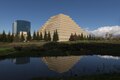 | 7,360 × 4,912 (206.9 MB) | Fæ | LOC 2013630972, Carol M. Highsmith collection. P5009.19813 TIFF (206.9mb) |
File usage
The following page uses this file:
Global file usage
The following other wikis use this file:
- Usage on en.wikipedia.org
- Usage on www.wikidata.org
Metadata
Explore the world

United states
New York

Japan
Tokyo

Singapore
Singapore
