
 Français
 Italiano
Size of this PNG preview of this SVG file: 776 × 599 pixels. Other resolutions: 311 × 240 pixels | 622 × 480 pixels | 995 × 768 pixels | 1,280 × 988 pixels | 2,560 × 1,977 pixels | 1,238 × 956 pixels.
Original file (SVG file, nominally 1,238 × 956 pixels, file size: 7.19 MB)
This is a file from the Wikimedia Commons and may be used by other projects. Information from its description page there is shown below. Commons is a freely licensed media file repository. |
Summary
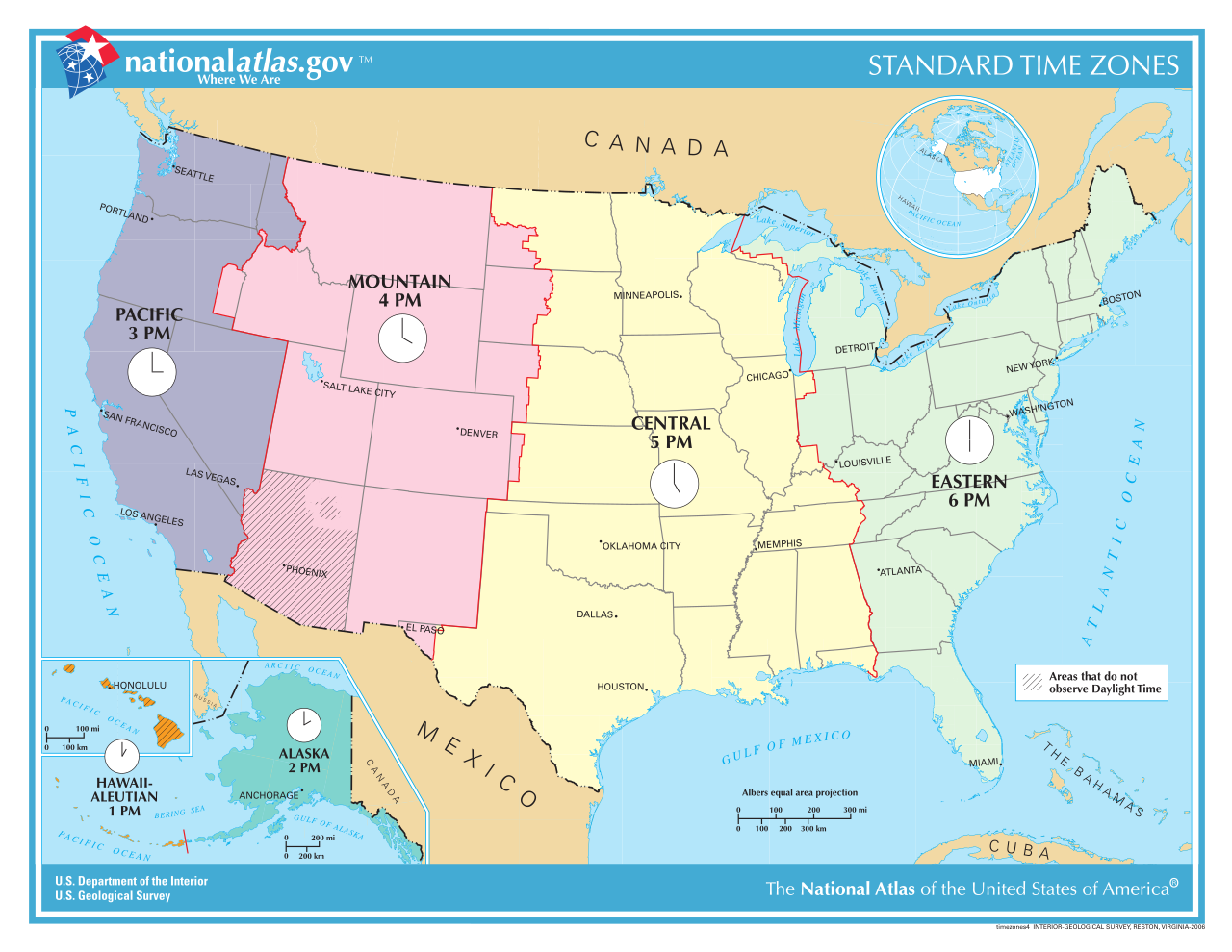
| Description | A map of the time zones of the United States; converted from a PDF file. |
| Date | |
| Source | http://nationalatlas.gov/printable/images/pdf/reference/timezones4.pdf, from http://nationalatlas.gov/printable/timezones.html |
| Author | NationalAtlas.gov; uploaded by User:RaviC |
| Other versions | Derivative works of this file: US-Timezones-as.svg Image:TimeZonesUSA.png, Image:National-atlas-timezones-2006.gif |
Licensing
This map was obtained from an edition of the National Atlas of the United States. Like almost all works of the U.S. federal government, works from the National Atlas are in the public domain in the United States. Online access: NationalAtlas.gov | 1970 print edition: Library of Congress, Perry-Castañeda Library
|
File history
Click on a date/time to view the file as it appeared at that time.
| Date/Time | Thumbnail | Dimensions | User | Comment | |
|---|---|---|---|---|---|
| current | 18:08, 29 July 2013 | | 1,238 × 956 (7.19 MB) | Alejandroadan | Putting the current (July 29, 2013) version of the image to update the old one (although from what I've seen they look the same). |
| 20:45, 17 October 2008 |  | 792 × 612 (5.62 MB) | RaviC | {{Information |Description=A map of the time zones of the United States; converted from [http://nationalatlas.gov/printable/images/pdf/reference/timezones4.pdf a PDF file]. |Source=http://nationalatlas.gov/printable/ima |
File usage
The following 2 pages use this file:
Global file usage
The following other wikis use this file:
- Usage on ar.wikipedia.org
- Usage on bs.wikipedia.org
- Usage on da.wikipedia.org
- Usage on de.wikipedia.org
- Usage on en.wikipedia.org
- Usage on es.wikipedia.org
- Usage on fa.wikipedia.org
- Usage on fr.wikipedia.org
- Wikipédia:Statistiques des anecdotes de la page d'accueil/Visibilité des anecdotes (2017)
- Heure aux États-Unis
- Discussion:Heure aux États-Unis
- Wikipédia:Statistiques des anecdotes de la page d'accueil/Visibilité des anecdotes (2017)/2017 11
- Wikipédia:Réseaux sociaux/Publications/archives/novembre 2017
- Wikipédia:Le saviez-vous ?/Archives/2017
- Liste des régions des États-Unis
- Usage on fr.wikivoyage.org
- Usage on fy.wikipedia.org
- Usage on hi.wikivoyage.org
- Usage on ja.wikipedia.org
- Usage on lt.wikipedia.org
- Usage on no.wikipedia.org
- Usage on ro.wikipedia.org
- Usage on ru.wikipedia.org
- Usage on simple.wikipedia.org
- Usage on sl.wikipedia.org
- Usage on sv.wikipedia.org
- Usage on tr.wikipedia.org
- Usage on uk.wikipedia.org
- Usage on ur.wikipedia.org
- Usage on uz.wikipedia.org
- Usage on vi.wikipedia.org
- Usage on www.wikidata.org
- Usage on zh.wikipedia.org
Metadata
Explore the world

United states
New York

Japan
Tokyo

Singapore
Singapore
