
 Français
 Italiano
Size of this preview: 522 × 600 pixels. Other resolutions: 209 × 240 pixels | 418 × 480 pixels | 668 × 768 pixels | 891 × 1,024 pixels | 1,600 × 1,838 pixels.
Original file (1,600 × 1,838 pixels, file size: 910 KB, MIME type: image/png)
This is a file from the Wikimedia Commons and may be used by other projects. Information from its description page there is shown below. Commons is a freely licensed media file repository. |
 | This file was moved to Wikimedia Commons from wts.oldwikivoyage using a bot script. All source information is still present. It requires review. Additionally, there may be errors in any or all of the information fields; information on this file should not be considered reliable and the file should not be used until it has been reviewed and any needed corrections have been made. Once the review has been completed, this template should be removed. For details about this file, see below. Check now! |
Summary
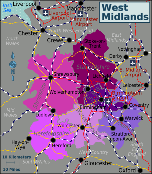
| Description | Map of the West Midlands region showing counties and major cities Source: Image:West_Midlands_region_map.svg & :Image:UK map.svg
|
| Date | 30 November 2006 (original upload date) |
| Source | :Image:UK map.svg |
| Author | User: (WT-shared) Paul. at wts wikivoyage |
| Location | West Midlands |
Licensing
This file is licensed under the Creative Commons Attribution-Share Alike 1.0 Generic license.
- You are free:
- to share – to copy, distribute and transmit the work
- to remix – to adapt the work
- Under the following conditions:
- attribution – You must give appropriate credit, provide a link to the license, and indicate if changes were made. You may do so in any reasonable manner, but not in any way that suggests the licensor endorses you or your use.
- share alike – If you alter, transform, or build upon this work, you must distribute the resulting work under the same license as the original.
Original upload log
| This file was imported from Wikivoyage WTS. |
The original description page was here. All following user names refer to wts.wikivoyage-old.
- 2006-11-30 19:51 (WT-shared) Paul.[dead link] 890×977 (35930 bytes) Map of the West Midlands region showing counties and major cities Source: [[:Image:UK map.svg]] {{location|West_Midlands_(region)}} (Import from wikitravel.org/shared)
- 2006-11-30 19:54 (WT-shared) Paul.[dead link] 890×977 (34604 bytes) (Import from wikitravel.org/shared)
- 2012-04-10 12:18 (WT-shared) Travelpleb[dead link] 1600×1838 (931487 bytes) {{Imagecredit|credit=Travelpleb|captureDate=10th April 2012|location=West Midlands|source=Image:West_Midlands_region_map.svg|caption=The Wes (Import from wikitravel.org/shared)
File history
Click on a date/time to view the file as it appeared at that time.
| Date/Time | Thumbnail | Dimensions | User | Comment | |
|---|---|---|---|---|---|
| current | 03:51, 18 December 2012 | | 1,600 × 1,838 (910 KB) | OgreBot | (BOT): Reverting to most recent version before archival |
| 03:50, 18 December 2012 |  | 890 × 977 (34 KB) | OgreBot | (BOT): Uploading old version of file from wts.wikivoyage; originally uploaded on 2006-11-30 19:54:12 by (WT-shared) Paul. | |
| 03:50, 18 December 2012 |  | 890 × 977 (35 KB) | OgreBot | (BOT): Uploading old version of file from wts.wikivoyage; originally uploaded on 2006-11-30 19:51:54 by (WT-shared) Paul. | |
| 03:24, 18 November 2012 |  | 1,600 × 1,838 (910 KB) | MGA73bot2 | {{BotMoveToCommons|wts.oldwikivoyage|year={{subst:CURRENTYEAR}}|month={{subst:CURRENTMONTHNAME}}|day={{subst:CURRENTDAY}}}} == {{int:filedesc}} == {{Information |description=Map of the West Midlands region showing counties and major cities Source: [[:... |
File usage
The following page uses this file:
Global file usage
The following other wikis use this file:
- Usage on el.wikivoyage.org
- Usage on fr.wikivoyage.org
- Usage on he.wikivoyage.org
- Usage on it.wikivoyage.org
- Usage on nl.wikivoyage.org
Metadata
Explore the world

United states
New York

Japan
Tokyo

Singapore
Singapore
