

 French
 Deutsch
Monfragüe National Park (Spanish: Parque Nacional de Monfragüe) is in the Extremadura region of Spain. Monfragüe is located roughly in the center of the province of Cáceres, within the triangle formed by the well-known cities of Plasencia, Trujillo, and Cáceres. Its central axis is the Tagus River as it flows through gently rolling mountains surrounded by vast *dehesas* (wooded pastures).
This Park is a haven for birdwatchers and nature enthusiasts. This rugged landscape of cliffs, rivers, and Mediterranean forests is renowned for its impressive avian population, including majestic eagles and rare vultures. Embark on well-marked trails that lead to panoramic viewpoints, offering breathtaking vistas of the park's diverse ecosystems. Keep an eye out for the iconic Monfragüe Castle, perched atop a hill and offering a glimpse into the region's history. With its remarkable biodiversity and stunning vistas, Monfragüe beckons those seeking an authentic Spanish wilderness experience.
Understand
[edit | edit source]
Monfragüe National Park is a protected area in western Spain’s Extremadura region, renowned as one of the Iberian Peninsula’s most important birdwatching destinations. Situated in the province of Cáceres, it lies between the Tagus (Tajo) and Tiétar rivers, where rugged quartzite ridges, deep gorges, and extensive Mediterranean forests create a landscape of exceptional ecological value.
Originally declared a natural park in 1979 to prevent eucalyptus plantations from destroying native scrub and forest, Monfragüe was upgraded to national park status in 2007 and forms the core of a larger UNESCO Biosphere Reserve designated in 2003. The reserve covers about 116,160 hectares, with the national park itself spanning roughly 18,000 hectares of predominantly Mediterranean woodland, dehesa (open oak savanna), rocky outcrops, and riverine habitats.
The park supports over 200 vertebrate species and harbours some of Europe’s largest colonies of black vultures, as well as significant populations of Spanish imperial eagles, griffon vultures, Bonelli’s eagles, and black storks. Mammals include Iberian lynx, red deer, wild boar, and otters along the riverbanks. Vegetation is dominated by holm oak, cork oak, and wild olive, with gallery forests and scrub providing critical habitat connectivity. Historic landmarks such as Castillo de Monfragüe and the dramatic Salto del Gitano cliff add cultural depth to the natural experience. Today, Monfragüe functions both as a sanctuary for endangered species and as a model of traditional agrosylvopastoral land use, illustrating centuries of coexistence between people and Mediterranean ecosystems.
Visitor information
[edit | edit source]
- Park_website : Parque Nacional de Monfragüe
- Visitor_centers
- 1 Villarreal de San Carlos Tourist office (Centro de recepción e información de visitantes de Villarreal de San Carlos), Villareal de San Carlos, Caceres, ☏ +34 927 19 91 34, info.monfrague@juntaex.es. 9:30-18:00.
- 2 North park entrance tourist office (Centro de Visitantes Norte "Jesús Garzón"), Carretera EX- 208, km 9. Malpartida de Plasencia, ☏ +34 927 27 49 73, centronortemonfrague@juntaex.es.
- 3 Torrejón el Rubio tourist office (Oficina de Información Torrejón el Rubio), Calle El Madroño, Torrejón el Rubio.

Get in
[edit | edit source]Monfragüe National Park lies in central Cáceres province, roughly halfway between Plasencia and Trujillo. The main visitor hub is the village of Villarreal de San Carlos, from which most trails and viewpoints are accessed
By bus
[edit | edit source]- There is a direct local bus between Plasencia and Villarreal de San Carlos operated by Emiz Transport. Services run twice a week (typically on Mondays and Fridays), take around 35 minutes, and cost about €2–3 each way.
By car
[edit | edit source]- From Madrid
- The drive from Madrid to the heart of the Monfragüe Biosphere Reserve covers about 250 km and typically takes around 2½ hours. From the M‑40 ring road, take the A‑5 motorway heading southwest toward Navalmoral de la Mata. This route serves the eastern side of the reserve (including Romangordo, Higuera de Albalat, Deleitosa, Jaraicejo and Casas de Miravete).
- To reach the core park area, continue on the A‑5 to Navalmoral de la Mata, then join the EX‑A1 toward Plasencia. Follow signs for Monfragüe and take the exit for Villarreal de San Carlos via the EX‑208.
- From Cáceres (south)
- Approaching from the south on the A‑66 (Autovía de la Plata), leave the motorway before Plasencia and take the EX‑A1 in the direction of Navalmoral de la Mata. The first exit leads to Villarreal de San Carlos; staying on the EX‑A1 longer will bring you to villages further east in the reserve.
- From Salamanca (north)
- Coming from the north on the A‑66, pass Plasencia, then take the EX‑A1 toward Navalmoral de la Mata. As from the south, the first exit provides access to Villarreal de San Carlos, while continuing eastward reaches other reserve towns.
By taxi
[edit | edit source]Taxis are available in Plasencia and can take you directly to Villarreal de San Carlos in around 25–30 minutes; the road distance is about 26 km.
Fees and permits
[edit | edit source]Get around
[edit | edit source]Parking
[edit | edit source]- 1 Castle Parking (Aparcamiento del castillo), EX-208.
- 2 Parking Villarreal de San Carlos.
- 3 Serrejón motorhome area, Calle Las Eras, Serrejón.
See
[edit | edit source].jpg)
- 1 Castle of Monfragüe (Castillo de Monfragüe) (follow red trail or park in castle parking area). Throughout its history, this watchtower has been used by military orders, Celts, Romans, Arabs, and Christians, all of whom made it a key defensive stronghold thanks to the privileged location of the hill upon which it stands—rising directly above the steep, rugged terrain that begins at the banks of the Tagus River. From the keep, one can view almost the entire national park and many of the inlets formed by the dammed waters of the Tagus River within the Alcántara Reservoir. It contains the Ermita de Monfragüe church
- 2 Cardinal's Bridge (Puente del Cardenal). Dating back to the medieval period and featuring a total of five arches, it was built in the 15th century at the behest of Juan de Carvajal, the Bishop of Plasencia. Its central section was destroyed during the Peninsular War, necessitating the use of a wooden crossing until the structure was restored in 1859. Today, it is frequently submerged beneath the waters of the Tagus River. The Cañada Real de la Plata (also known as the Cañada Real de la Vizana) ran across it.
- 3 [Villareal de San carlos Animal habitat exhibition] (Exposicion Animales Naturalizados). It presents a recreation of various ecosystems and their wildlife, focusing on the loss of biodiversity.

Main attractions - Must See
[edit | edit source]Natural places
[edit | edit source]Historic buildings
[edit | edit source]Religious places
[edit | edit source]Cities around the park
[edit | edit source]- 4 Villarreal de San Carlos. It was founded between 1758 and 1788 by Charles III as a permanent garrison to monitor the Monfragüe area, which was plagued by banditry at the time. Attacks between the Puente del Cardenal and the Puerto de la Serrana were very frequent. The settlement included a barracks, a rectory, a church, and a school, and was equipped with water fountains to supply the residents. It never grew to have a large population, and consequently remained a hamlet of Serradilla. Today is the main entrance to the national park.
- 5 Torrejón el Rubio. is a small municipality in Cáceres province, Extremadura, whose northern territory forms part of Monfragüe National Park. It includes key park landmarks such as Monfragüe Castle, the Salto del Gitano viewpoint, and prehistoric rock‑art shelters, and serves as a main gateway for visitors exploring the reserve’s forests and birdlife. The village sits on the southern side of the Tagus River, between the Sierra de las Corchuelas and the Almonte, and its entire municipal area lies within the Monfragüe Biosphere Reserve. With around 500–600 inhabitants, it combines traditional agrosylvopastoral landscapes with visitor facilities, interpretation centres, and access to major trails and viewpoints.

Itineraries
[edit | edit source]
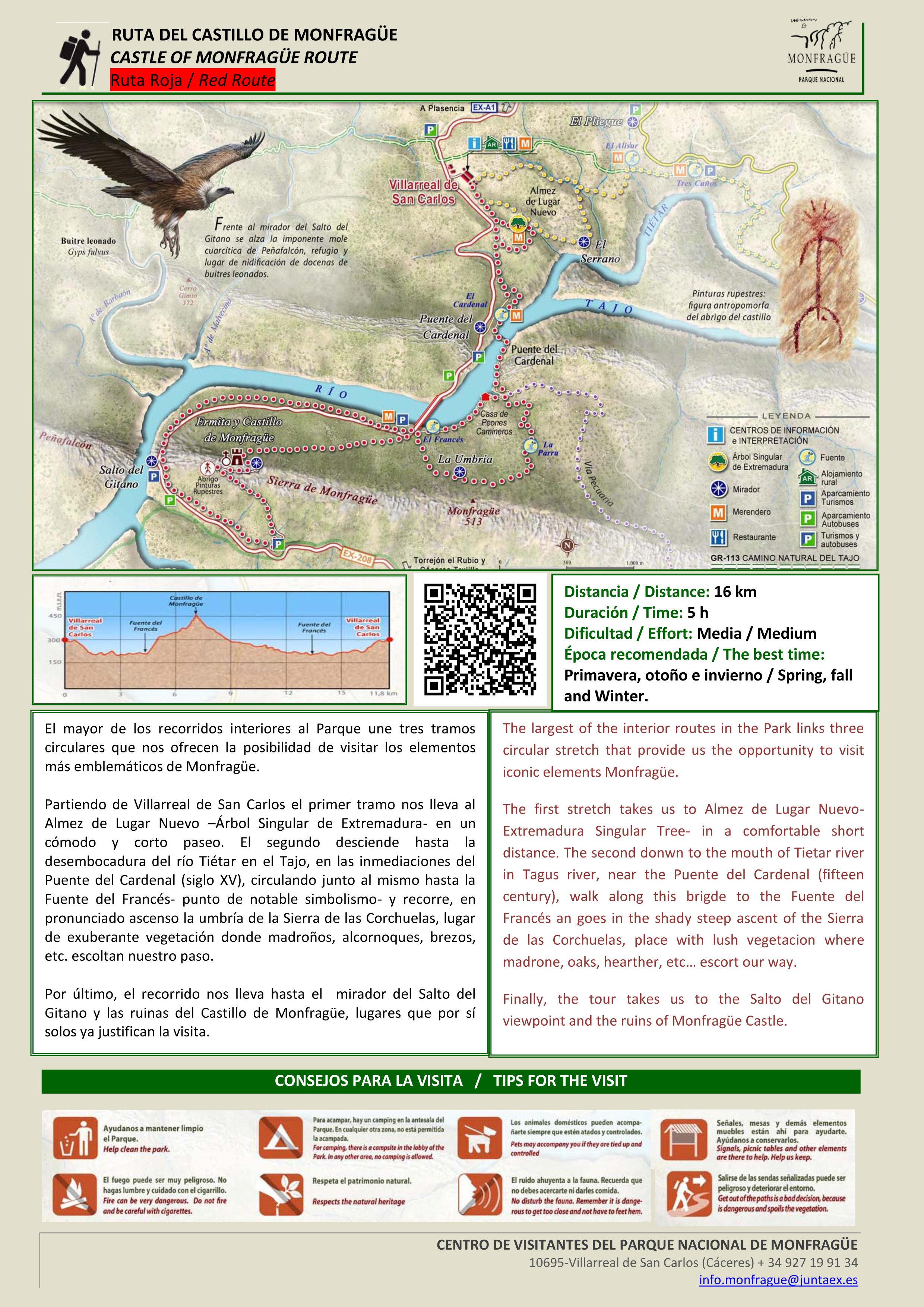
- Castle of Monfragüe route - Red route (Ruta roja. Castillo de Monfragüe). 16km, around 5h, effort=medium,
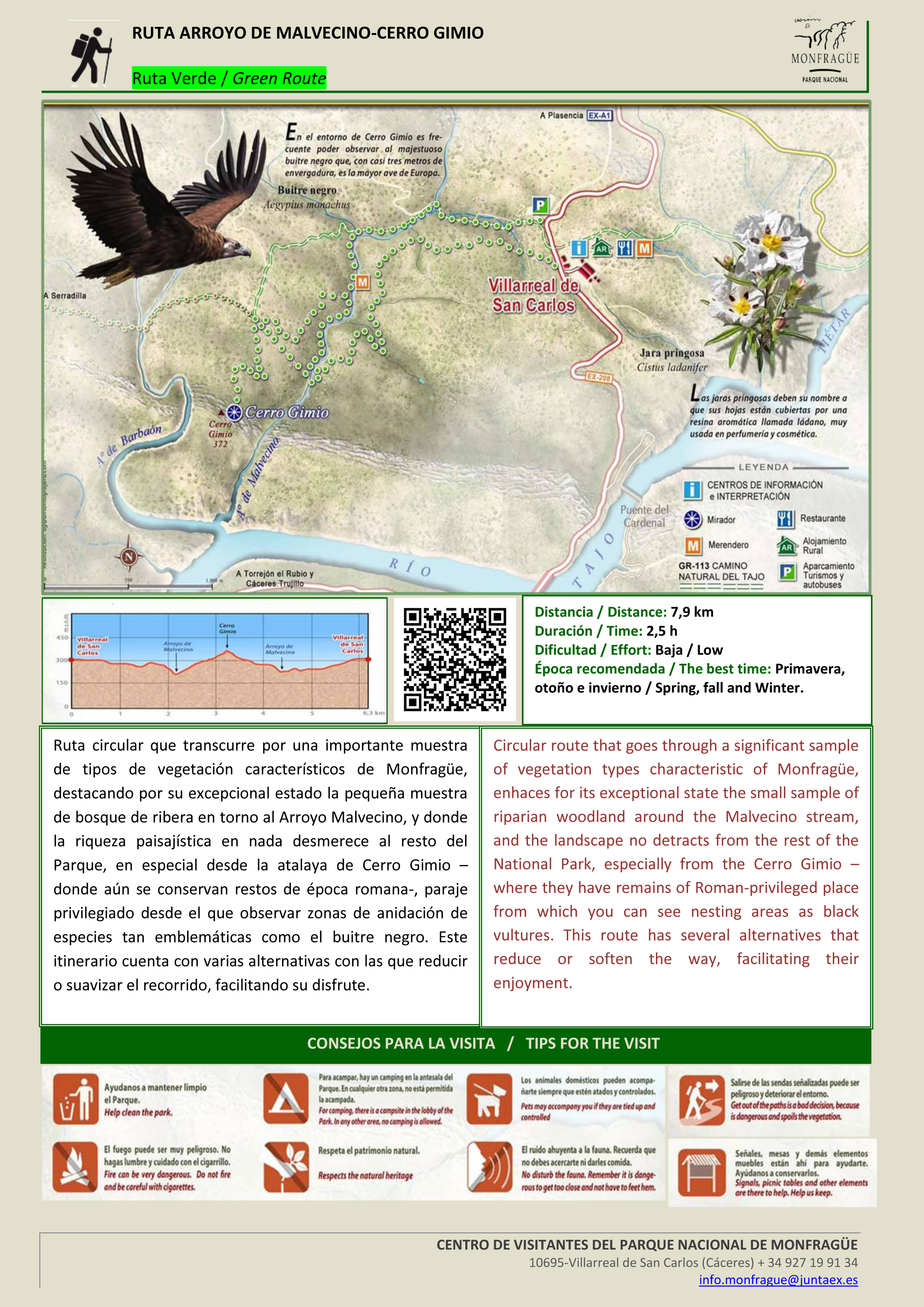
- Arroyo de Malvecino-Cerro Gimio route - Green route (Ruta verde. Arroyo de Malvecino-Cerro Gimio). 8km, 2.5h, effort=low
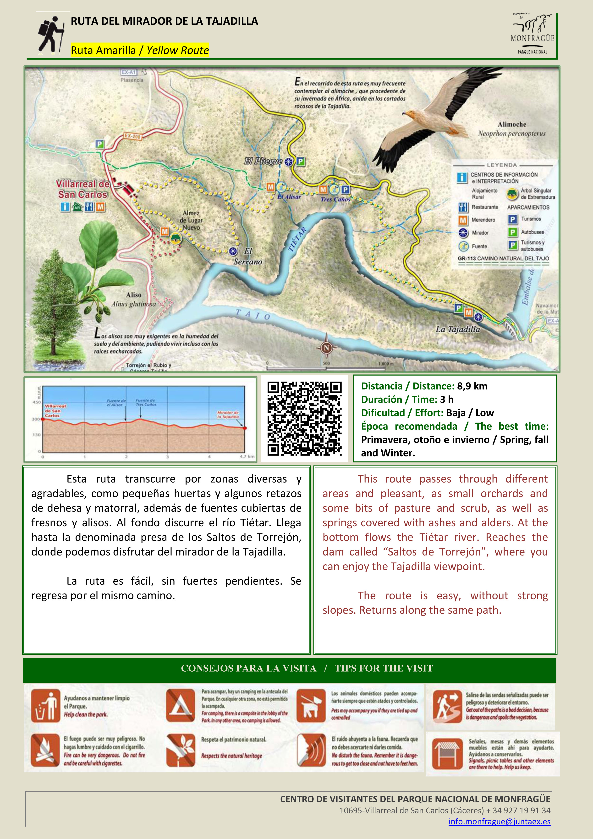
- Tajadilla viewpoint route - yellow route (Ruta amarilla. Mirador de la Tajadilla). 9km , 3h, effort=low
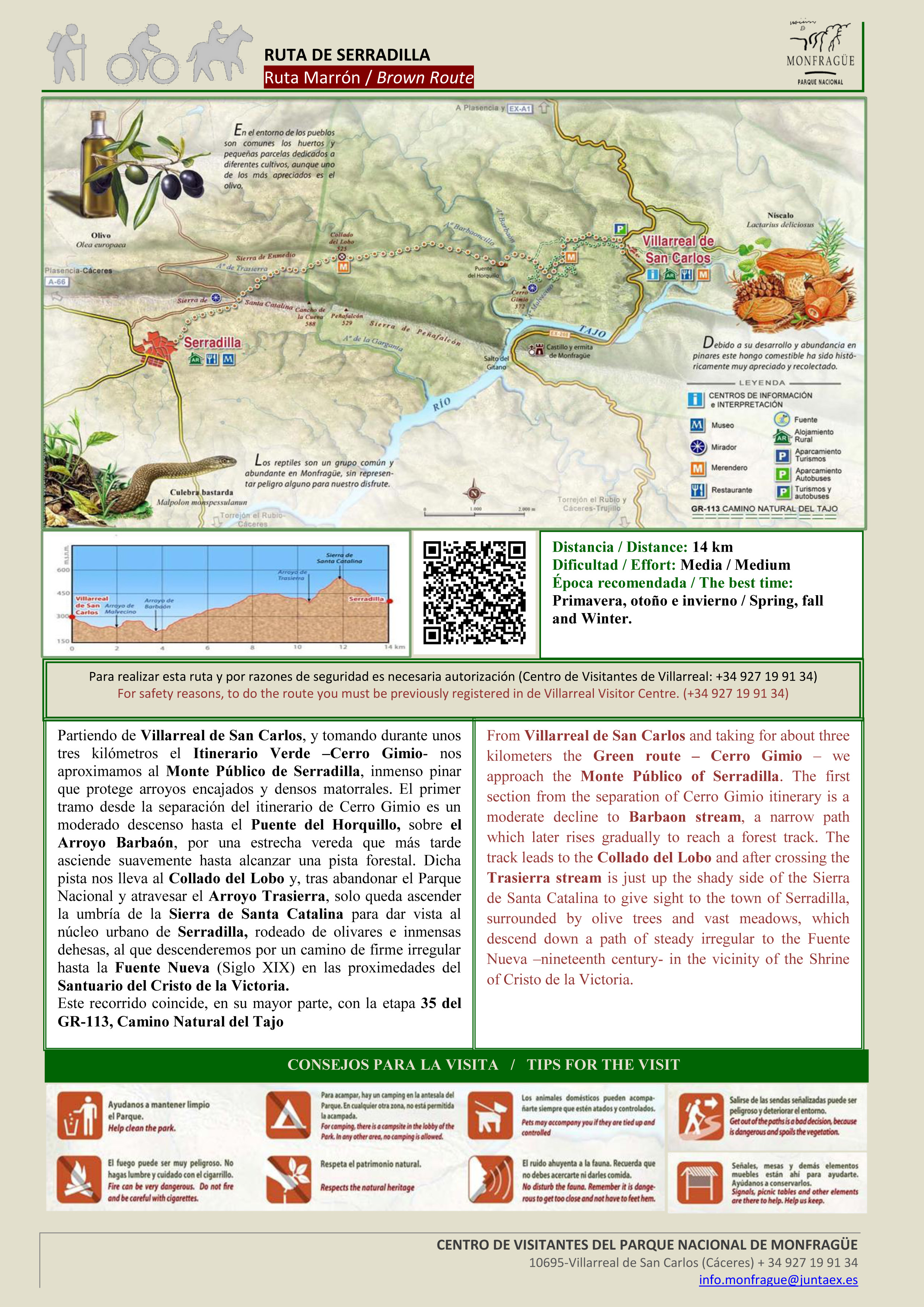
- Serradilla route - brown route (Ruta marrón. Serradilla). 14km, effort=medium
- Torrejón el Rubio route - purple route (Ruta morada. Ruta de Torrejón el Rubio). A permit is required. 13km (one way)

Viewpoints
[edit | edit source]- 6 La Báscula Viewpoint (Mirador La Báscula), Carretera de La Bazagona. it has parking
- 7 La Higuerilla Viewpoint (Mirador La Higuerilla), Carretera de La Bazagona.
- 8 Portilla del Tiétar Viewpoint (Mirador Portilla del Tiétar), Carretera de La Bazagona.
- 9 Salto del Gitano Viewpoint (Mirador Salto del Gitano).
Prehistoric
[edit | edit source]- 10 Rock Art Interpretation Centre (Centro de Interpretación del Arte Rupestre), Torrejon el rubio, ☏ +34 927 45 52 92, arterupestre@torrejonelrubio.es.
Do
[edit | edit source]Hiking
[edit | edit source]- long range
- local hikes
- suggested walks
Mountain biking
[edit | edit source]Road cycling
[edit | edit source]Climbing
[edit | edit source]Caving
[edit | edit source]Birdwatching
[edit | edit source]Events
[edit | edit source]Buy
[edit | edit source]Eat
[edit | edit source]- 1 Posada El Arriero, Paseo Pizarro 22, Torrejón el Rubio.
- 2 Restaurante Monfragüe, Villarreal de San Carlos, Cáceres, ☏ +34 686 709 329, info@monfraguerural.com.
- 3 Al Mofrag restaurant, Villarreal de San Carlos, Cáceres, ☏ +34 927 19 9205.
Picnic
[edit | edit source]- 4 La Mala Vuelta, Carretera de La Bazagona (on the track to access Torrejón hydroelectric plant), ☏ +34 927 45 5050. has a viewpoint
- 5 La Tajadilla Picnic area (Area Recreativa de la Tajadilla). it has parking.
- 6 Fuente del francés Picnic area (Area Recreativa de la Fuente del francés), Carretera de Plasencia a Zorita (EX-208). it has parking
- 7 Puente del Cardenal Picnic area (Área Recreativa del Puente del Cardenal), Carretera de Plasencia a Zorita (EX-208). it has parking and a viewpoint
- 8 Huerto del Ojaranzo Picnic area (Huerto del Ojaranzo) (access by yellow route.).
Drink
[edit | edit source]Springs
[edit | edit source]Sleep
[edit | edit source]Lodging
[edit | edit source]- 1 Hotel 4* Parque de Monfragüe, Ctra. Plasencia-Trujillo, km 37 ,Torrejón el Rubio, ☏ +34 927 455 278. from €75.
- 2 Albergue "La Dehesa", C/ Gabriel y Galán 17 Torrejón el Rubio, ☏ +34 927 45 5178.
Camping
[edit | edit source]- 3 Camping Monfrague, Ctra Plasencia, Puerta de Trujillo, km.9, ☏ +34 927 45 92 33, contacto@campingmonfrague.com.
Stay safe
[edit | edit source]- Exercise caution on the Park's roads and in the surrounding area; you may easily encounter animals. To observe and listen to wildlife in its natural state, it is best to park at designated viewpoints and avoid making excessive noise.
- Some iconic viewpoints are located along public roads, so please drive carefully. Watching wildlife from your vehicle can be distracting and lead to traffic accidents.
- Getting too close to wild animals is dangerous. Feeding them is prohibited, as it alters their natural behavior.
- When planning a long hike in autumn or winter, take your return journey into account, bearing in mind that afternoons are short and darkness falls early during these seasons.
- Straying from established paths and trails is unwise; it leads to greater fatigue, and you may find your way blocked by vegetation or even get lost.
- Fire poses a serious risk. Do not light fires, and be extremely careful with cigarettes; remember that discarding lit cigarette butts is dangerous.
- Mobile phone coverage within the Park can be limited. Even if you have your phone with you, let someone know your whereabouts before setting out.
- In the event of an emergency, call 112.
- Monfragüe is a mountain area with hot summers and cold winters. Bring clothing suitable for the conditions: In winter, a coat or raincoat and appropriate footwear. In summer, a hat for sun protection, plenty of water, and sunscreen.
- Wear comfortable footwear for walking, such as trainers or hiking boots.
- If you choose a long route, it is important to carry an adequate supply of food and water.
- Camping and parking caravans, motorhomes, or similar vehicles between 10:00 PM and 6:00 AM for more than two consecutive hours is prohibited. For camping, there is a campsite just outside the Park, between Plasencia and Villarreal de San Carlos.
- Swimming and boating are not permitted within the National Park.
- Invasive species endanger native flora and fauna; never abandon your pet in the wild!
- Domestic animals may accompany you, provided they are kept on a leash and under control.
- Writing on walls or any other Park feature leaves a negative mark.
- Signposts and picnic tables are there to assist you.
- Help us preserve them so that others, like you, can use them too.
- Using trash bins helps keep the Park clean. In areas where bins are scarce, remember to collect your waste and carry it with you until you can dispose of it properly.
- Cutting or uprooting vegetation deprives others of the chance to enjoy it.
- Excessive noise disturbs the wildlife and causes you to miss the opportunity to observe and listen to animals in their natural state.
- Binoculars are essential for observing the Park's abundant birdlife.