U.S. Highway 395
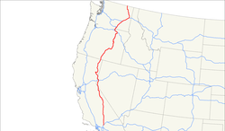
The U.S. Highway 395 is a 1,300 miles (2,100 km) long highway that runs inland from north to south through the states of Washington, Oregon, and California, where a short stretch passes through Nevada. The route, created in 1926, is the main (and, in many places, only) road that follows the Sierra Nevada and Cascade mountains on their eastern side. This side is more rugged and more remote than the west. The highway is a gateway to national forests, parks, and ski resorts throughout its course.

Understand
[edit]It provides access to some of the most beautiful places in the western states of the US, like the Mojave Desert, Death Valley National Park, and Yosemite National Park. Despite the region's arid climate, there are national forests along the route of the highway as well, including 1 Humboldt–Toiyabe National Forest and 2 Inyo National Forest.
In California and Nevada, the highway roughly follows the eastern (and significantly less populated) side of the Sierra Nevada mountain range. Mount Whitney, the highest peak in the contiguous U.S., isn't directly visible from the route. This part of the route is a desert valley with the forested Sierra Nevada to the west and the White Mountains to the east. To the north, the route's climate becomes cooler and less arid due to elevation change. The section of the highway in Nevada passes through two of the largest population centers on the route, namely Carson City and Reno.
The northern part of the route, crossing Oregon and Washington, tracks east of the volcanic Cascades. US-395 twice crosses the Columbia River, the core of an agricultural region known for its fruit production. This region is, relative to the western sides of either state, low in population density.
Prepare
[edit]
Given that this route takes more than 20 hours to drive in total, consider booking hotels in the larger towns along the route, and plan to take some time to explore the mountains. If you take the route during the summer, the Owens Lake region in the south will be hot, so if you are taking detours, go to the higher altitude sites that are cooler. During the winter and early spring, most mountain roads are closed due to snow.
For those sensitive to altitude, the elevation change is significant along the route, passing 8,000 ft (2,400 m) at the highest point close to Mono Lake.
Go
[edit]For travel by bus, the Eastern Sierra Transit Authority (ESTA) offers daily routes from Lone Pine to Reno and Mammoth Lakes to Lancaster, plus two shorter express routes:
- The Lone Pine Express operates between Lone Pine and Bishop, with the route taking about 80 minutes, four times a day weekdays and twice daily weekends.
- The Mammoth Express operates between Bishop and Mammoth Lakes, with the route taking about one hour, four times a day.
Southern California
[edit]The southernmost part of the US 395 starts in 3 Hesperia in the south and travels 356 miles (573 km) north to Topaz Lake on the California-Nevada border. Plenty of gas stations will feed the need of your car along the way, no more than 25 miles (40 km) apart. Prices away from larger places might go up substantially, plan accordingly.
"Eastern Sierra Transit" operates bus routes from Inyokern to Reno in Nevada (see Routes & Schedules). A ticket from Inyokern to Bishop is $25, Bishop to Reno $53 (as of 2024).
Remarkable locations:
- 4 Lone Pine, access to Mount Whitney, the highest point in the contiguous United States
- 5 Manzanar, site of an Internment Camp for people of Japanese ancestry during World War II
- 6 Big Pine, gateway to the Ancient Bristlecone Pine Forest
- 7 Bishop, largest populated place in Inyo County
- 8 Mammoth Lakes, popular skiing destination
- 9 Lee Vining, northeastern access to Yosemite National Park via CA-120 (summer only)
- 10 Mono Lake, salty lake renowned for its scenic beauty, tufa rock formations, and migratory birds
- A detour to the remote ghost town of 11 Bodie, one of the best preserved in the U.S., is possible north of Mono Lake
Nevada
[edit]- 12 Carson City, capital of Nevada
- 13 Reno, second largest city in Nevada
Northern California
[edit]Oregon
[edit]
- 15 Lakeview, the tallest town in Oregon at 4,802 feet, also known as one of the best places in North America for hang-gliding and paragliding.
- 16 Burns, location of the Malheur National Wildlife Refuge.
- 17 John Day, a small town with an 1865 stagecoach stop that functioned as a Chinese community center and general store from the 1880s to 1940s, now a museum.
- 18 Pendleton, an agricultural and manufacturing town quite close to the Umatilla Indian Reservation, whose Tamástslikt Cultural Institute could make for an interesting slight detour from the route.
- 19 Hermiston, south of the Columbia River on the border with the state of Washington
Washington
[edit]- 20 Kennewick, the main city of Washington's Tri-Cities urban area
- 21 Pasco, across the Columbia River from Kennewick and also one of the Tri-Cities
- 22 Spokane, major city in eastern Washington
- 23 Kettle Falls, close to the border with British Columbia; known for its proximity to the Lake Roosevelt National Recreation Area
Go next
[edit]US-395 continues into British Columbia as BC-395. This road connects to BC-3, leading to Christina Lake to the east and Grand Forks to the west.


 Français
 Italiano


