
 Français
 Italiano
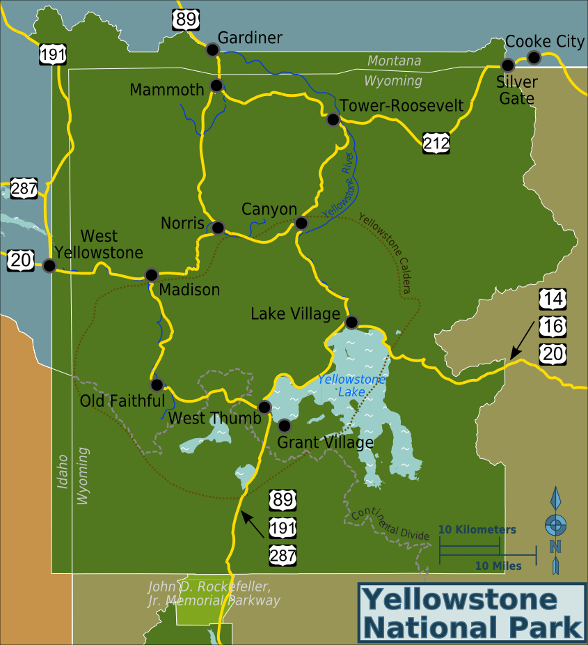
Tamaño de esta previsualización: 547 × 599 píxeles. Otras resoluciones: 219 × 240 píxeles | 438 × 480 píxeles | 845 × 926 píxeles.
Archivo original (845 × 926 píxeles; tamaño de archivo: 258 kB; tipo MIME: image/png)
Éste es un archivo de Wikimedia Commons, un depósito de contenido libre hospedado por la Fundación Wikimedia
Más abajo se reproduce su página de descripción con la información sobre su origen y licencia.
Resumen
| Descripción | English: Yellowstone National Park map, created by Ryan Holliday [1]. PNG generated from File:Yellowstone-area-map.svg. Based on open source data from OpenStreetMap [2] and public domain information from nps.gov [3]. | |||
| Fecha | ||||
| Fuente | Trabajo propio | |||
| Autor | Ryan Holliday (Wrh2) | |||
| Permiso (Reutilización de este archivo) |
|
Licencia
Yo, titular de los derechos de autor de esta obra, la publico en los términos de las siguientes licencias:
 | Se autoriza la copia, distribución y modificación de este documento bajo los términos de la licencia de documentación libre GNU, versión 1.2 o cualquier otra que posteriormente publique la Fundación para el Software Libre; sin secciones invariables, textos de portada, ni textos de contraportada. Se incluye una copia de la dicha licencia en la sección titulada Licencia de Documentación Libre GNU. |
Este archivo se encuentra bajo la licencia Creative Commons Attribution-Share Alike 3.0 Unported, 2.5 Generic, 2.0 Generic y 1.0 Generic
- Eres libre:
- de compartir – de copiar, distribuir y transmitir el trabajo
- de remezclar – de adaptar el trabajo
- Bajo las siguientes condiciones:
- atribución – Debes otorgar el crédito correspondiente, proporcionar un enlace a la licencia e indicar si realizaste algún cambio. Puedes hacerlo de cualquier manera razonable pero no de manera que sugiera que el licenciante te respalda a ti o al uso que hagas del trabajo.
- compartir igual – En caso de mezclar, transformar o modificar este trabajo, deberás distribuir el trabajo resultante bajo la misma licencia o una compatible como el original.
Puedes usar la licencia que prefieras.
Historial del archivo
Haz clic sobre una fecha y hora para ver el archivo tal como apareció en ese momento.
| Fecha y hora | Miniatura | Dimensiones | Usuario | Comentario | |
|---|---|---|---|---|---|
| actual | 05:57 5 nov 2012 | | 845 × 926 (258 kB) | Wrh2 | Make it clearer that the arrow is pointing to the road, not the caldera. |
| 05:57 5 nov 2012 |  | 845 × 926 (258 kB) | Wrh2 | Label tweaks. | |
| 05:56 5 nov 2012 |  | 845 × 926 (256 kB) | Wrh2 | Add geographic features. | |
| 05:56 5 nov 2012 |  | 1119 × 1203 (290 kB) | Wrh2 | Minor tweaks. | |
| 05:55 5 nov 2012 |  | 1082 × 1119 (287 kB) | Wrh2 | Include more of the surrounding area. | |
| 05:54 5 nov 2012 |  | 855 × 934 (210 kB) | Wrh2 | {{Information |Description ={{en|1=Yellowstone National Park map, created by Ryan Holliday [http://www.mountaininterval.org]. PNG generated from File:Yellowstone-area-map.svg. Based on open source data from OpenStreetMap [http://openstreetmap... |
Usos del archivo
La siguiente página usa este archivo:
Uso global del archivo
Las wikis siguientes utilizan este archivo:
- Uso en bn.wikivoyage.org
- Uso en en.wikivoyage.org
- Uso en fr.wikivoyage.org
- Uso en he.wikivoyage.org
- Uso en it.wikivoyage.org
Metadatos
Explore the world

United states
New York

Japan
Tokyo

Singapore
Singapore
