
 Français
 Italiano
Archivo original (archivo SVG, nominalmente 254 × 254 píxeles, tamaño de archivo: 660 kB)
Resumen
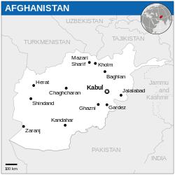
| Descripción | Català: Mapa de localització d'Afganistan. English: Locator map of Afghanistan. |
| Fecha | |
| Fuente | English: Afghanistan Locator Map (ReliefWeb), ESRI, UNCS, The Times Atlas of the World |
| Autor | |
| Otras versiones |
Other related versions:[] UNOCHA Versions
CIA WFB Versions
Other English Versions |
| SVG desarrollo |
_-_AFG_-_UNOCHA.svg&lang=ca)
_-_AFG_-_UNOCHA.svg&lang=en)
_-_AFG_-_UNOCHA.svg&lang=fa)
_-_AFG_-_UNOCHA.svg&lang=fr)
_-_AFG_-_UNOCHA.svg&lang=id)
_-_AFG_-_UNOCHA.svg&lang=ps)
_-_AFG_-_UNOCHA.svg&lang=vi)
_-_AFG_-_UNOCHA.svg)
_-_AFG_-_UNOCHA-bn.svg)
_-_AFG_-_UNOCHA-es.svg)


_-_AFG_-_UNOCHA.svg)
Este archivo SVG contiene texto incrustado que puede traducirse a su lengua, mediante un editor que admita SVG (como XML o texto). Para más información, véase: Sobre la traducción de archivos SVG. |
Este archivo se traduce usando elementos <switch> de SVG. ¡Todas las traducciones se almacenan en el propio archivo! Aprender más. Para insertar este archivo en tu idioma (si está disponible) usa el parámetro Para traducir este archivo a tu idioma, puede usar la herramienta de traducción de SVG. Alternativamente, puedes descargar el archivo a tu ordenador, añadir la traducción utilizando cualquier software con el que estés familiarizado y resubirlo con el mismo nombre. Encontrarás más ayuda en el Taller de Ilustraciones / Laboratorio Gráfico si no estás seguro de cómo hacerlo. |
_-_AFG_-_UNOCHA.svg)
Licencia
- Eres libre:
- de compartir – de copiar, distribuir y transmitir el trabajo
- de remezclar – de adaptar el trabajo
- Bajo las siguientes condiciones:
- atribución – Debes otorgar el crédito correspondiente, proporcionar un enlace a la licencia e indicar si realizaste algún cambio. Puedes hacerlo de cualquier manera razonable pero no de manera que sugiera que el licenciante te respalda a ti o al uso que hagas del trabajo.
 This map is part of a collection of 216 free country maps, created by the UN Office for the Coordination of Humanitarian Affairs (OCHA), to be used in print, web or broadcast products. The ReliefWeb Location Maps released here are maps that highlight a country, its capital, major populated places and the surrounding regions. Attribution Requirements Using the map without modifications: ensure that the sources and the disclaimer are below the map. Credit as follows: "Credit: OCHA". For use with alteration: remove the OCHA logo and disclaimer following any modification to the map, but keep the data sources as mentioned below the map. Credit the modified map as follows: "Based on OCHA map". You are responsible for the content of your map. We are keen to receive your feedback and hear how you used OCHA's maps. We would be grateful if you would notify us by e-mail and share your work with us. UN Disclaimer The designations employed and the presentation of material of this map do not imply the expression of any opinion whatsoever on the part of the Secretariat of the United Nations concerning the legal status of any country, territory, city or area or of its authorities or concerning the delimitation of its frontiers or boundaries. |
Historial del archivo
Haz clic sobre una fecha y hora para ver el archivo tal como apareció en ese momento.
_-_AFG_-_UNOCHA.svg&dir=prev)
_-_AFG_-_UNOCHA.svg&offset=20140825031003)
_-_AFG_-_UNOCHA.svg&offset=&limit=20)
_-_AFG_-_UNOCHA.svg&offset=&limit=50)
_-_AFG_-_UNOCHA.svg&offset=&limit=100)
_-_AFG_-_UNOCHA.svg&offset=&limit=250)
_-_AFG_-_UNOCHA.svg&offset=&limit=500)
| Fecha y hora | Miniatura | Dimensiones | Usuario | Comentario | |
|---|---|---|---|---|---|
| actual | 17:54 4 dic 2024 | | 254 × 254 (660 kB) | Manlleus | File uploaded using svgtranslate tool (https://svgtranslate.toolforge.org/). Added translation for ca. |
| 03:58 27 jul 2024 |  | 254 × 254 (656 kB) | شاه زمان پټان | File uploaded using svgtranslate tool (https://svgtranslate.toolforge.org/). Added translation for ps. | |
| 14:17 16 ene 2023 |  | 254 × 254 (652 kB) | Amqui | File uploaded using svgtranslate tool (https://svgtranslate.toolforge.org/). Added translation for fr. | |
| 01:13 19 nov 2022 |  | 254 × 254 (648 kB) | Pengetik-AM | File uploaded using svgtranslate tool (https://svgtranslate.toolforge.org/). Added translation for id. | |
| 14:32 3 sep 2021 |  | 254 × 254 (647 kB) | Darafsh | File uploaded using svgtranslate tool (https://svgtranslate.toolforge.org/). Added translation for fa. | |
| 16:13 1 mar 2021 |  | 254 × 254 (643 kB) | Trần Nguyễn Minh Huy | File uploaded using svgtranslate tool (https://svgtranslate.toolforge.org/). Added translation for vi. | |
| 16:06 1 mar 2021 |  | 254 × 254 (643 kB) | Trần Nguyễn Minh Huy | File uploaded using svgtranslate tool (https://svgtranslate.toolforge.org/). Added translation for vi. | |
| 03:03 18 nov 2014 |  | 254 × 254 (641 kB) | Pharos | Reverted to version as of 03:10, 25 August 2014 | |
| 23:37 17 nov 2014 |  | 254 × 254 (2,39 MB) | Pharos | fix rectangle | |
| 03:10 25 ago 2014 |  | 254 × 254 (641 kB) | Matt Heard | Removed UNOCHA watermark. This modified image is based on the OCHA map and should be included with the OCHA sources and disclaimer. The watermark was removed without attempting to reconstruct the India-Pakistan border behind it, so there is a gap in th... |
Usos del archivo
No hay páginas que enlacen a este archivo.
Uso global del archivo
Las wikis siguientes utilizan este archivo:
- Uso en arz.wikipedia.org
- Uso en ast.wikipedia.org
- Uso en as.wikipedia.org
- Uso en awa.wikipedia.org
- Uso en azb.wikipedia.org
- Uso en bh.wikipedia.org
- Uso en btm.wikipedia.org
- Uso en ca.wikipedia.org
- Uso en chy.wikipedia.org
- Uso en cy.wikipedia.org
- Uso en dag.wikipedia.org
- Uso en da.wikipedia.org
- Uso en de.wikivoyage.org
- Uso en diq.wikipedia.org
- Uso en dtp.wikipedia.org
- Uso en dty.wikipedia.org
- Uso en el.wikipedia.org
- Uso en en.wikipedia.org
- Uso en eo.wikinews.org
- Uso en es.wikipedia.org
- Uso en fa.wikipedia.org
- Uso en ff.wikipedia.org
- Uso en fr.wikinews.org
- Uso en fr.wikivoyage.org
- Uso en ga.wikipedia.org
- Uso en gl.wikipedia.org
- Uso en gom.wikipedia.org
- Uso en gpe.wikipedia.org
- Uso en ha.wikipedia.org
- Uso en hi.wikipedia.org
- Uso en ia.wikipedia.org
- Uso en iba.wikipedia.org
- Uso en id.wikipedia.org
- Uso en incubator.wikimedia.org
- Uso en it.wikipedia.org
- Uso en kab.wikipedia.org
Ver más uso global de este archivo.
_-_AFG_-_UNOCHA.svg)
Metadatos
_-_AFG_-_UNOCHA.svg)
Explore the world

United states
New York

Japan
Tokyo

Singapore
Singapore
