
 Français
 Italiano
Resumen
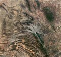
| Descripción | English: This Copernicus Sentinel-2 image features the diverse landscape surrounding Monterrey, the capital of the northeast state of Nuevo León, Mexico. Zoom in to explore this image at its full 10 m resolution or click on the circles to learn more. This image, acquired on 5 March 2023, shows a region which combines mountain ranges, agricultural plains, arid areas, as well as densely populated urban centres. The metropolitan area of Monterrey, visible in shades of grey in the centre of the image, is the second largest in Mexico with around five million inhabitants. It is crossed by the Santa Catarina River, which is usually fed by flowing underground water, although the river was predominantly dry when this image was acquired. Monterrey is 540 m above sea level and is nestled at the foothills of the Sierra Madre Oriental, the folded mountain range that can be seen in the bottom-left of the image. The Cumbres de Monterrey National Park lies in the northern part of the Sierra Madre Oriental and includes the famous Cerro de la Silla (or Saddle Mountain), which dominates Monterrey’s skyline. The park is a UNESCO Biosphere Reserve and provides approximately 50% of the water consumed in Monterrey and its metropolitan area. The grey area visible west of the park is the city of Saltillo, the capital of the Mexican state of Coahuila. Saltillo is one of the most industrialised areas in the country and, thanks to its dry and cool climate, has become a popular holiday destination. The region south of the park appears mostly arid, with only a few centre-pivot irrigation fields visible in the brown areas in the bottom of the image. On the contrary, numerous agricultural areas stand out in the right of the image, with many square-shaped fields thickening along the course of small rivers and canals. |
| Fecha | 24 de marzo de 2023 (fecha de carga) |
| Fuente | Earth from Space: Monterrey, Mexico |
| Autor | European Space Agency |
| Otras versiones |
|
| Activity | Observing the Earth |
| Mission | Sentinel-2 |
| Set | Earth from Space image collection |
| System | Copernicus |
Licencia
 | Esta imagen contiene datos que provienen de un satélite del Programa Copérnico, como Sentinel-1, Sentinel 2 o Sentinel-3. Se require atribución cuando se utilice esta imagen. Atribución: Contiene datos modificados de Copernicus Sentinel 2023 El uso de datos Sentinel del Programa Cópernico está regulado por la legislación europea: Reglamento Delegado (UE) No 1159/2013 de la Comisión y el Reglamento (UE) No 377/2014. Los pasajes relevantes son:
Se permitirá el acceso gratuito a los datos dedicados del GMES y a la información de servicio del GMES a través de las plataformas de difusión del GMES [...].
Se dará acceso a los datos dedicados del GMES y a la información de servicio del GMES a los efectos que se detallan a continuación, siempre y cuando sean lícitos:
Los datos dedicados del GMES y la información de servicio del GMES podrán utilizarse en todo el mundo sin limitación de tiempo.
Los datos dedicados del GMES y la información de servicio del GMES se facilitarán a los usuarios sin ninguna garantía explícita o implícita, incluyendo lo tocante a la calidad y la idoneidad para cualesquiera fines. |
This media was created by the European Space Agency (ESA). Where expressly so stated, images or videos are covered by the Creative Commons Attribution-ShareAlike 3.0 IGO (CC BY-SA 3.0 IGO) licence, ESA being an Intergovernmental Organisation (IGO), as defined by the CC BY-SA 3.0 IGO licence. The user is allowed under the terms and conditions of the CC BY-SA 3.0 IGO license to Reproduce, Distribute and Publicly Perform the ESA images and videos released under CC BY-SA 3.0 IGO licence and the Adaptations thereof, without further explicit permission being necessary, for as long as the user complies with the conditions and restrictions set forth in the CC BY-SA 3.0 IGO licence, these including that:
See the ESA Creative Commons copyright notice for complete information, and this article for additional details. |  | |
Este archivo se encuentra bajo la licencia Creative Commons Atribución Compartir-Igual 3.0 IGO. Atribución: ESA, CC BY-SA IGO 3.0
| ||
Historial del archivo
Haz clic sobre una fecha y hora para ver el archivo tal como apareció en ese momento.
| Fecha y hora | Miniatura | Dimensiones | Usuario | Comentario | |
|---|---|---|---|---|---|
| actual | 17:51 24 mar 2023 | | 8986 × 8365 (17,23 MB) | OptimusPrimeBot | #Spacemedia - Upload of https://www.esa.int/var/esa/storage/images/esa_multimedia/images/2023/03/earth_from_space_monterrey_mexico/24764114-1-eng-GB/Earth_from_Space_Monterrey_Mexico.jpg via Commons:Spacemedia |
Usos del archivo
No hay páginas que enlacen a este archivo.
Metadatos
Explore the world

United states
New York

Japan
Tokyo

Singapore
Singapore
