
 Français
 Italiano
.jpg)
Resumen
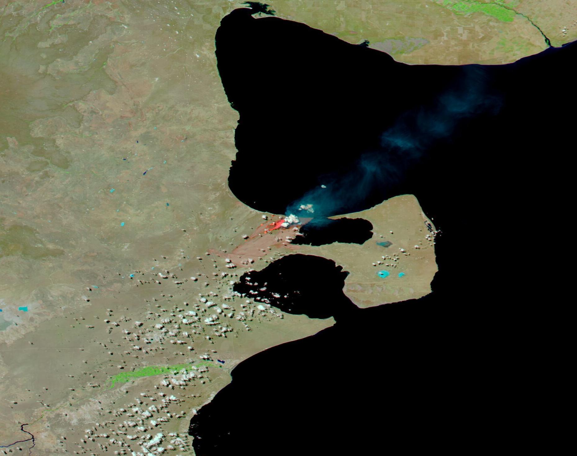
| Descripción | English: Fierce wildfires blazed across parts of Patagonia in the opening days of 2022, charring tens of thousands of hectares. One estimate of the destruction, reported by local media, was 302,451 hectares (747,373 acres) burned in Argentina in the last week, 20,000 hectares (49,421 acres) on the Uruguay coast, and 11,000 hectares (27,482 acres) in south-central Chile in the same timeframe. This has caused widespread damage to forests and grasslands and killed numerous animals. In addition, a helicopter fighting a wildfire near Nahuel Huapi National Park in Neuquen Province, Argentina crashed on December 29, killing two personnel on board. Longstanding dry conditions are a major contributing factor to the wildfires. According to Wildfire Today, the Federal Council of the Environment (Cofema) of Argentina and the Argentine Ministry of the Environment have declared an emergency throughout Argentina for the last 12 months due to drought and the risk of fires. While some wildfires ignite due to natural causes, such as lighting strikes, authorities have estimated that 95 percent of the fires here have started due to human activity. On January 4, the Moderate Resolution Imaging Spectroradiometer (MODIS) on board NASA’s Aqua satellite acquired a false-color image of a massive fire burning in the Puerto Madryn region in the province of Chubut, Argentina. This type of image uses infrared and visible light to highlight fire and burn scars. In this combination, vegetation is bright lime green, shallow water appears electric blue while deep (ocean) water looks inky-blue or black. Open land or land with little vegetation appears tan. Fire appears brick red, smoke looks grey, and burn scars (areas charred by fire) may appear brick red, brown, or black. Very fresh burn scars typically look brick red, while older scars appear darker (brown or black) before vegetation begins to return to the burnt area. This false-color view shows active fire accompanied by smoke and surrounded by a very large brick-red burn scar, as well as several other long burn scars crossing the landscape near the major active fire. The wildfires in Chubut ignited at the start of the new year, on January 1, according to local media. On January 4, authorities estimated that 80,000 – 90,000 hectares (197,684-222,395 acres) had burnt in the southern province of Chubut, with the area near the town of Puerto Madryn the most affected. The region is agricultural, with many milk and meat producing farms. The rapidly advancing fire has burnt many buildings and killed livestock, and if it advances eastward, it will threaten the Valdes Peninsula, a UNESCO site and home to many rare and exotic animals and plants. The origin of the fire is unknown, but lightning strike is considered the most likely cause. | ||
| Fecha | Tomada el 4 de enero de 2022 | ||
| Fuente | Fires and Burn Scars near Puerto Madryn, Argentina (direct link)
| ||
| Autor | MODIS Land Rapid Response Team, NASA GSFC |
| This media is a product of the Aqua mission Credit and attribution belongs to the mission team, if not already specified in the "author" row |
Licencia
| Este archivo es de dominio público porque fue creado por la NASA. Las políticas sobre copyright de la NASA estipulan que «el material de la NASA no está protegido con copyright a menos que se indique lo contrario». (Políticas sobre copyright de la NASA o Políticas sobre la utilización de imágenes del Jet Propulsion Laboratory). | ||
 | Advertencias:
|
Historial del archivo
Haz clic sobre una fecha y hora para ver el archivo tal como apareció en ese momento.
| Fecha y hora | Miniatura | Dimensiones | Usuario | Comentario | |
|---|---|---|---|---|---|
| actual | 22:22 9 ene 2024 | | 1858 × 1466 (190 kB) | OptimusPrimeBot | #Spacemedia - Upload of http://modis.gsfc.nasa.gov/gallery/images/image01072022_250m.jpg via Commons:Spacemedia |
Usos del archivo
No hay páginas que enlacen a este archivo.
.jpg)
Explore the world

United states
New York

Japan
Tokyo

Singapore
Singapore
