
 Français
 Italiano
Fichier d’origine (Fichier SVG, nominalement de 254 × 254 pixels, taille : 262 kio)
_-_ERI_-_UNOCHA.svg)
Description
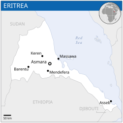
| Description | English: Locator map of Eritrea. |
| Date | |
| Source | English: Eritrea Locator Map (ReliefWeb), ESRI, UNCS, Natural Earth |
| Auteur | |
| SVG information |
Conditions d’utilisation
- Vous êtes libre :
- de partager – de copier, distribuer et transmettre cette œuvre
- d’adapter – de modifier cette œuvre
- Sous les conditions suivantes :
- paternité – Vous devez donner les informations appropriées concernant l'auteur, fournir un lien vers la licence et indiquer si des modifications ont été faites. Vous pouvez faire cela par tout moyen raisonnable, mais en aucune façon suggérant que l’auteur vous soutient ou approuve l’utilisation que vous en faites.
 This map is part of a collection of 216 free country maps, created by the UN Office for the Coordination of Humanitarian Affairs (OCHA), to be used in print, web or broadcast products. The ReliefWeb Location Maps released here are maps that highlight a country, its capital, major populated places and the surrounding regions. Attribution Requirements Using the map without modifications: ensure that the sources and the disclaimer are below the map. Credit as follows: "Credit: OCHA". For use with alteration: remove the OCHA logo and disclaimer following any modification to the map, but keep the data sources as mentioned below the map. Credit the modified map as follows: "Based on OCHA map". You are responsible for the content of your map. We are keen to receive your feedback and hear how you used OCHA's maps. We would be grateful if you would notify us by e-mail and share your work with us. UN Disclaimer The designations employed and the presentation of material of this map do not imply the expression of any opinion whatsoever on the part of the Secretariat of the United Nations concerning the legal status of any country, territory, city or area or of its authorities or concerning the delimitation of its frontiers or boundaries. |
Historique du fichier
Cliquer sur une date et heure pour voir le fichier tel qu'il était à ce moment-là.
| Date et heure | Vignette | Dimensions | Utilisateur | Commentaire | |
|---|---|---|---|---|---|
| actuel | 29 décembre 2022 à 02:52 | | 254 × 254 (262 kio) | Wikijahnn | File uploaded using svgtranslate tool (https://svgtranslate.toolforge.org/). Added translation for ca. |
| 18 novembre 2014 à 23:54 |  | 254 × 254 (263 kio) | Pharos | try without logo for now | |
| 18 novembre 2014 à 03:12 |  | 254 × 254 (302 kio) | Pharos | try without logo for now | |
| 21 avril 2014 à 00:28 |  | 254 × 254 (302 kio) | UN OCHA maps bot | == {{int:filedesc}} == {{Information |description={{en|1=Locator map of Eritrea.}} |date=2013 |source={{en|1=[http://reliefweb.int/map/eritrea/eritrea-location-map-2013 Eritrea Locator Map (ReliefWeb)]}} |author={{en|1=[[w:en:United Na... |
Utilisation du fichier
La page suivante utilise ce fichier :
Usage global du fichier
Les autres wikis suivants utilisent ce fichier :
- Utilisation sur ann.wikipedia.org
- Utilisation sur arz.wikipedia.org
- Utilisation sur ast.wikipedia.org
- Utilisation sur bh.wikipedia.org
- Utilisation sur ca.wikipedia.org
- Utilisation sur ckb.wikipedia.org
- Utilisation sur dag.wikipedia.org
- Utilisation sur de.wikivoyage.org
- Utilisation sur diq.wikipedia.org
- Utilisation sur en.wikipedia.org
- Utilisation sur eo.wikinews.org
- Utilisation sur es.wikipedia.org
- Utilisation sur eu.wikipedia.org
- Utilisation sur ff.wikipedia.org
- Utilisation sur fr.wikinews.org
- Utilisation sur ga.wikipedia.org
- Utilisation sur gd.wikipedia.org
- Utilisation sur gl.wikipedia.org
- Utilisation sur gpe.wikipedia.org
- Utilisation sur gur.wikipedia.org
- Utilisation sur ha.wikipedia.org
- Utilisation sur he.wikivoyage.org
- Utilisation sur ht.wikipedia.org
- Utilisation sur ia.wikipedia.org
- Utilisation sur id.wikipedia.org
- Utilisation sur ig.wikipedia.org
- Utilisation sur ilo.wikipedia.org
- Utilisation sur incubator.wikimedia.org
- Utilisation sur ja.wikipedia.org
- Utilisation sur kab.wikipedia.org
- Utilisation sur lb.wikipedia.org
- Utilisation sur lfn.wikipedia.org
- Utilisation sur lo.wikipedia.org
- Utilisation sur mdf.wikipedia.org
- Utilisation sur mg.wikipedia.org
- Utilisation sur mt.wikipedia.org
- Utilisation sur pl.wikipedia.org
- Utilisation sur rm.wikipedia.org
- Utilisation sur ro.wikipedia.org
- Utilisation sur sco.wikipedia.org
- Utilisation sur sd.wikipedia.org
- Utilisation sur shi.wikipedia.org
- Utilisation sur so.wikipedia.org
- Utilisation sur tt.wikipedia.org
- Utilisation sur vec.wikipedia.org
- Utilisation sur www.wikidata.org
Voir davantage sur l’utilisation globale de ce fichier.
_-_ERI_-_UNOCHA.svg)
Métadonnées
_-_ERI_-_UNOCHA.svg)
Explore the world

United states
New York

Japan
Tokyo

Singapore
Singapore
