
 Français
 Italiano
Taille de cet aperçu PNG pour ce fichier SVG : 541 × 541 pixels. Autres résolutions : 240 × 240 pixels | 480 × 480 pixels | 768 × 768 pixels | 1 024 × 1 024 pixels | 2 048 × 2 048 pixels.
Fichier d’origine (Fichier SVG, nominalement de 541 × 541 pixels, taille : 239 kio)
Description
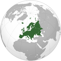
| Description | العربية: الخريطة الهجائية لأوروبا English: Europe Français : Europe ქართული: ევროპა | ||||
| Date | |||||
| Source | Travail personnel
| ||||
| Auteur | Ssolbergj | ||||
| Autres versions | Œuvres dérivées de ce fichier : Europe orthographic Caucasus Urals boundary.svg .svg)
| ||||
| SVG information | Le code de ce fichier SVG n'est pas valide en raison de 98 erreurs. Cette carte SVG utilise du texte encapsulé qui peut être traduit facilement à l'aide d'un éditeur de texte. |

.svg)
.svg)
.svg)
.svg)
.svg)
.svg)
.svg)
.svg)
.svg)
.svg)
.svg)
.svg)
.svg)
.svg)
.svg)
.svg)
.svg)
.svg)
.svg)
.svg)
.svg)
.svg)
.svg)
.svg)
.svg)
.svg)
.svg)
.svg)
.svg)
.svg)
.svg)
.svg)
.svg)
.svg)
.svg)
.svg)
.svg)
.svg)
.svg)
.svg)
.svg)
.svg)
.svg)
.svg)
.svg)
.svg)
.svg)
.svg)
.svg)
.svg)
.svg)
.svg)
.svg)
.svg)
.svg)
.svg)
.svg)
.svg)
.svg)
.svg)
.svg)
.svg)
.svg)

.svg)
.svg)
.svg)
.svg)
.svg)
.svg)
.svg)
.svg)
.svg)

.svg)

.svg)

.svg)
.svg)
.svg)
.svg)
.svg)
.svg)
.svg)


.svg)
.svg)
.svg)
.svg)
.svg)
.svg)
.svg)

.svg)
.svg)
.svg)
.svg)
.svg)
.svg)
.svg)
.svg)
.svg)
.svg)

.svg)
.svg)
.svg)
.svg)
.svg)
.svg)
.svg)
_without_national_boundaries.svg)
.svg)
.svg)
.svg)
.svg)
.svg)
.svg)

.svg)
.svg)
.png)
.svg)
.svg)
.svg)
.svg)

.svg)
.svg)
.svg)
.svg)
.svg)
.svg)
.svg)
.svg)
.svg)
.svg)
.svg)

.svg)
.svg)
.svg)
.svg)
.svg)
.svg)
.svg)
.svg)
.svg)

.svg)
.svg)

.svg)
.svg)
.svg)
.svg)
.svg)
.svg)
.svg)
.svg)
.svg)
.svg)
.svg)
.svg)
.svg)
.svg)
.svg)
.svg)
.svg)
.svg)
.svg)
.svg)
.svg)
.svg)
.svg)
.svg)
.svg)
.svg)
.svg)
_-_Crimea_disputed.svg)
.svg)
.svg)
.svg)
.svg)
.svg)
.svg)
.svg)
.svg)
.svg)
.svg)
.svg)
_political.svg)
.svg)
.svg)
.svg)
.svg)
_-_Crimea_disputed_-_no_borders.svg)
.svg)
.svg)
.svg)
.svg)
.svg)
.svg)
.svg)
.svg)
.svg)
.svg)
.svg)

.svg)
.svg)
.svg)

.png)
.svg)
.svg)
.svg)
.svg)
.svg)
.svg)
.svg)
.svg)
.svg)
.svg)
.svg)
.svg)
.svg)
.svg)
.svg)
.svg)
.svg)
.svg)
.svg)
.svg)
.svg)
.svg)
.svg)
.svg)
.svg)
.svg)
.svg)
.svg)
.svg)
.svg)
.svg)
.svg)
.svg)
.svg)
.png)
.svg)
.svg)
.svg)
_(orthographic_projection).png)
.svg)
.svg)
.svg)
Conditions d’utilisation
| This map is ineligible for copyright and therefore in the public domain, because it consists entirely of information that is common property and contains no original authorship. For more information, see Commons:Threshold of originality § Maps.
|
| Annotations | Cette image est annotée : Voir les annotations sur Wikimedia Commons |
Historique du fichier
Cliquer sur une date et heure pour voir le fichier tel qu'il était à ce moment-là.
.svg&dir=prev)
.svg&offset=20090705135015)
.svg&offset=&limit=20)
.svg&offset=&limit=50)
.svg&offset=&limit=100)
.svg&offset=&limit=250)
.svg&offset=&limit=500)
| Date et heure | Vignette | Dimensions | Utilisateur | Commentaire | |
|---|---|---|---|---|---|
| actuel | 10 novembre 2024 à 16:12 | | 541 × 541 (239 kio) | ReneeWrites | Reverted to version as of 09:46, 31 January 2016 (UTC) - Vandalism |
| 31 janvier 2016 à 09:46 |  | 541 × 541 (239 kio) | Christina1969 | Reverted to version as of 19:08, 20 June 2009 (UTC) | |
| 8 septembre 2013 à 20:21 |  | 541 × 541 (235 kio) | Chipmunkdavis | Reverted to version as of 22:37, 8 July 2009 Restore to version which notes source | |
| 12 septembre 2012 à 20:11 |  | 541 × 541 (82 kio) | Palosirkka | Scrubbed with http://codedread.com/scour/ | |
| 4 avril 2011 à 18:44 |  | 541 × 541 (235 kio) | Green, White and Gold | Reverted to version as of 22:37, 8 July 2009 | |
| 3 avril 2011 à 04:49 |  | 541 × 541 (239 kio) | ComtesseDeMingrelie | correcting Phasis riverbank | |
| 3 avril 2011 à 04:49 |  | 541 × 541 (235 kio) | ComtesseDeMingrelie | more common | |
| 3 avril 2011 à 04:44 |  | 541 × 541 (235 kio) | ComtesseDeMingrelie | most common definition | |
| 8 juillet 2009 à 22:37 |  | 541 × 541 (235 kio) | Bosonic dressing | rv: yes - per Natl Geographic Atlas of the World, which trumps what might be an original concoction | |
| 5 juillet 2009 à 13:50 |  | 541 × 541 (235 kio) | Ssolbergj | I based the border on http://en.wikipedia.org/wiki/File:Map_of_Europe_(political).png. Do you have a more reliable source? |
Utilisation du fichier
Aucune page n’utilise ce fichier.
Usage global du fichier
Les autres wikis suivants utilisent ce fichier :
- Utilisation sur ace.wikipedia.org
- Itali
- Peurancih
- Siprus
- Turuki
- Vatikan
- Iërupa
- Jeureuman
- Rumania
- Hongaria
- Polandia
- Moldova
- Austria
- Bèlgia
- Liechtenstein
- Luksèmburg
- Monakô
- Blanda
- Swiss
- Bèlarusia
- Bulgaria
- Ukraina
- Slowakia
- Rusia
- Denmark
- Swèdia
- Irlandia
- Islandia
- Latvia
- Lithuania
- Finlandia
- Èstonia
- Albania
- Andorra
- Bosnia Hèrzègovina
- Kroasia
- Malta
- Yunani
- Seupanyo
- Sèrbia
- San Marino
- Portugéh
- Monténègrô
- Slovenia
- Norwègia
- Cèkia
- Pola:Iërupa
- Kosovô
- Utilisation sur af.wikipedia.org
Voir davantage sur l’utilisation globale de ce fichier.
.svg)
Métadonnées
.svg)
Explore the world

United states
New York

Japan
Tokyo

Singapore
Singapore
