
 Français
 Italiano
Taille de cet aperçu : 386 × 599 pixels. Autres résolutions : 155 × 240 pixels | 309 × 480 pixels | 935 × 1 450 pixels.
Fichier d’origine (935 × 1 450 pixels, taille du fichier : 61 kio, type MIME : image/png)
 | Cette image (de type carte) devrait être recréée dans un format vectoriel, en tant que fichier SVG. Cela offrirait plusieurs avantages : voir Commons:Media for cleanup pour plus d’informations. Si une version SVG de cette image est déjà disponible, merci de bien vouloir l’envoyer. Après cela, remplacez ce modèle par {{vector version available|nouveau nom d’image.svg}}. |
Description
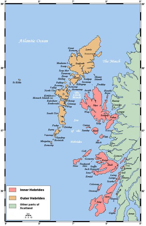
A map of the Inner and Outer Hebrides in Scotland.
This map's source is here, with the uploader's modifications, and the GMT homepage copie d'archive sur Wayback Machine says that the tools are released under the GNU General Public License.
Conditions d’utilisation
Kelisi, en tant que détenteur des droits d’auteur sur cette œuvre, la publie sous la licence suivante :
 | Vous avez la permission de copier, distribuer et modifier ce document selon les termes de la GNU Free Documentation License version 1.2 ou toute version ultérieure publiée par la Free Software Foundation, sans sections inaltérables, sans texte de première page de couverture et sans texte de dernière page de couverture. Un exemplaire de la licence est inclus dans la section intitulée GNU Free Documentation License. |
| Ce fichier est disponible selon les termes de la licence Creative Commons Attribution – Partage dans les Mêmes Conditions 3.0 Non Transposé. | ||
Attribution: | ||
| ||
| Ce bandeau de licence a été ajouté à ce fichier dans le cadre de la procédure de mise à jour des licences des images sous GFDL. |
Historique du fichier
Cliquer sur une date et heure pour voir le fichier tel qu'il était à ce moment-là.
| Date et heure | Vignette | Dimensions | Utilisateur | Commentaire | |
|---|---|---|---|---|---|
| actuel | 4 août 2007 à 21:06 | | 935 × 1 450 (61 kio) | Kelisi | Authorship |
| 28 janvier 2006 à 22:56 |  | 935 × 1 450 (61 kio) | Mschlindwein | A map of the Inner and Outer Hebrides in Scotland. This map's source is [http://www.aquarius.geomar.de/omc/make_map.html here], with the uploader's modifications, and the [http://gmt.soest.hawaii.edu/ GMT homepage] says that the tools are released under |
Utilisation du fichier
Aucune page n’utilise ce fichier.
Usage global du fichier
Les autres wikis suivants utilisent ce fichier :
- Utilisation sur af.wikipedia.org
- Utilisation sur an.wikipedia.org
- Utilisation sur ar.wikipedia.org
- Utilisation sur ast.wikipedia.org
- Utilisation sur az.wikipedia.org
- Utilisation sur bat-smg.wikipedia.org
- Utilisation sur be.wikipedia.org
- Utilisation sur bg.wikipedia.org
- Utilisation sur bn.wikipedia.org
- Utilisation sur br.wikipedia.org
- Ìle
- Inizi Gall
- Diùra
- Leòdhas
- Ulbha
- Beàrnaraigh Mòr
- Patrom:Inizi Gall
- Enez Cara
- Gioghaigh
- Rocabarraigh
- Inizi Barraigh
- Barraigh
- Bhatarsaigh
- Uibhist a Deas
- Hiort
- Uibhist a Tuath
- Ì Chaluim Chille
- Enez Sgitheanach
- Muile
- Na h-Eileanan Mora
- Na Hearadh
- Leòdhas agus na Hearadh
- Sgalpaigh na Hearadh
- Na h-Eileanan Ascrib
- Heisgeir
- Canaigh
- Càrna
- Rònaigh an Daimh
- Rònaigh (Sgitheanach)
- Cola
- Colbhasa
- The Minch
- Giogha
- Eige
- Orasaigh (Ìle)
- Orasaigh (Loch Bracadail)
- Rùm
Voir davantage sur l’utilisation globale de ce fichier.
Explore the world

United states
New York

Japan
Tokyo

Singapore
Singapore
