
 Français
 Italiano
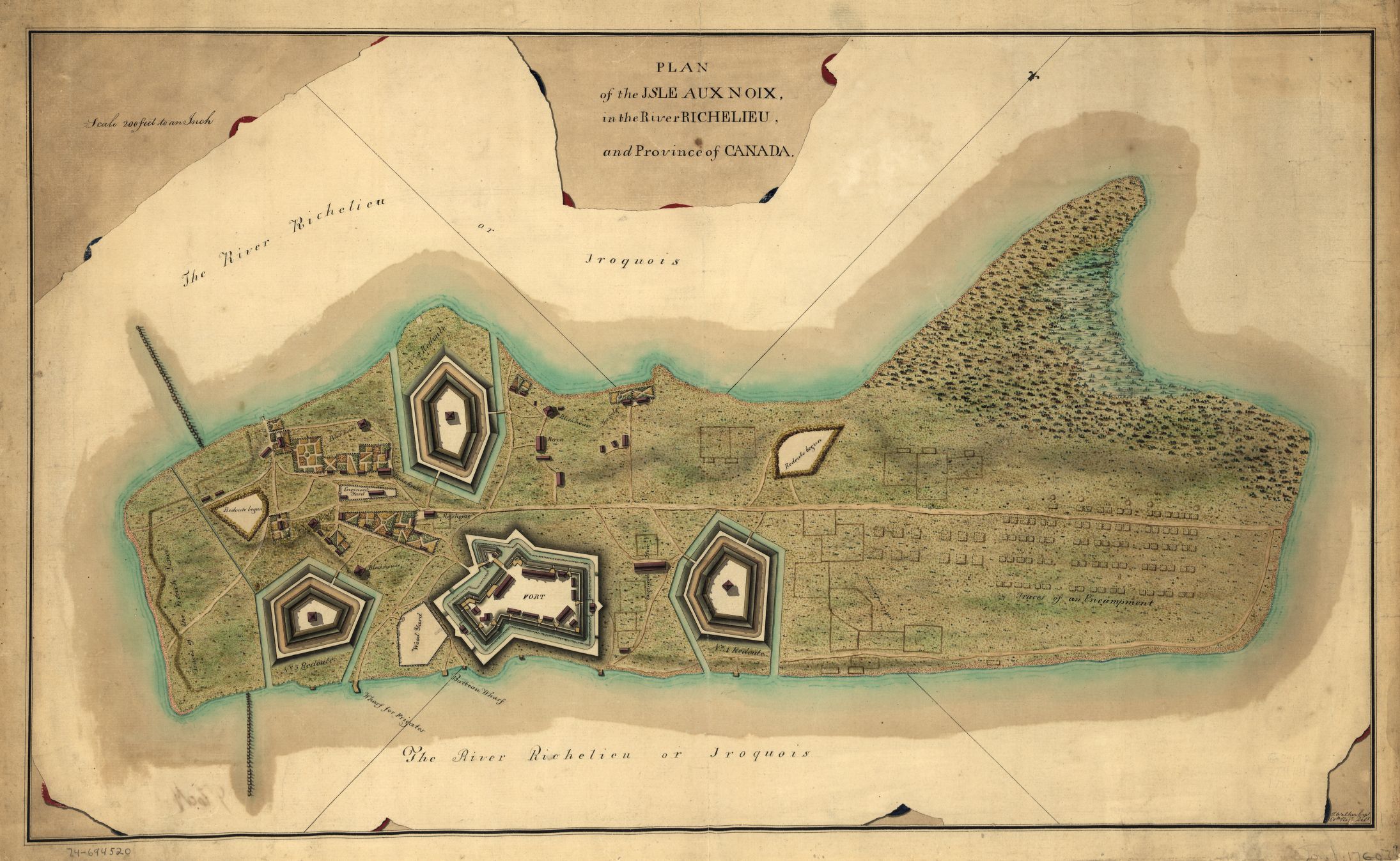
Taille de cet aperçu : 800 × 492 pixels. Autres résolutions : 320 × 197 pixels | 640 × 394 pixels | 1 024 × 630 pixels | 1 280 × 787 pixels | 2 190 × 1 347 pixels.
Fichier d’origine (2 190 × 1 347 pixels, taille du fichier : 534 kio, type MIME : image/jpeg)
Description
| Description | English: This is a map of fortifications on the Ile aux Noix, circa 1760. Caption reads: Plan of the Isle aux Noix, in the River Richelieu, and Province of Canada. [Signed:] T. Walker, Capt., 60th regt. delt. | ||
| Date | vers 1760 | ||
| Source |
| ||
| Auteur | Thomas Walker |

Conditions d’utilisation
| Ceci est une reproduction photographique fidèle d'une œuvre d'art originale en deux dimensions. L'œuvre d'art elle-même est dans le domaine public pour la raison suivante :
La position officielle de la Fondation Wikimedia est que « les représentations fidèles des œuvres d'art du domaine public en deux dimensions sont dans le domaine public et les exigences contraires sont une attaque contre le concept même de domaine public ». Pour plus de détails, voir Commons:Quand utiliser le bandeau PD-Art. Cette reproduction photographique est donc également considérée comme étant élevée dans le domaine public. Merci de noter qu'en fonction des lois locales, la réutilisation de ce contenu peut être interdite ou restreinte dans votre juridiction. Voyez Commons:Reuse of PD-Art photographs. {{PD-Art}} template without license parameter: please specify why the underlying work is public domain in both the source country and the United States (Usage: {{PD-Art|1=|deathyear=''year of author's death''|country=''source country''}}, where parameter 1= can be PD-old-auto, PD-old-auto-expired, PD-old-auto-1996, PD-old-100 or similar. See Commons:Multi-license copyright tags for more information.) | ||||
Historique du fichier
Cliquer sur une date et heure pour voir le fichier tel qu'il était à ce moment-là.
| Date et heure | Vignette | Dimensions | Utilisateur | Commentaire | |
|---|---|---|---|---|---|
| actuel | 15 avril 2009 à 01:58 | | 2 190 × 1 347 (534 kio) | Magicpiano | {{Information |Description={{en|1=This is a map of fortifications on the w:Ile aux Noix, circa 1760. Caption reads: Plan of the Isle aux Noix, in the River Richelieu, and Province of Canada. [Signed:] T. Walker, Capt., 60th regt. delt. }} |Source={{ |
Utilisation du fichier
Aucune page n’utilise ce fichier.
Usage global du fichier
Les autres wikis suivants utilisent ce fichier :
- Utilisation sur ceb.wikipedia.org
- Utilisation sur en.wikipedia.org
- Utilisation sur es.wikipedia.org
- Utilisation sur fa.wikipedia.org
- Utilisation sur fr.wikipedia.org
- Utilisation sur it.wikipedia.org
- Utilisation sur ja.wikipedia.org
- Utilisation sur www.wikidata.org
Métadonnées
Explore the world

United states
New York

Japan
Tokyo

Singapore
Singapore
