
 Français
 Italiano
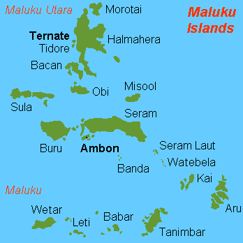
Pas de plus haute résolution disponible.
Karta_ID_Maluku_isl.PNG (348 × 348 pixels, taille du fichier : 4 kio, type MIME : image/png)
Description
| Description | English: Map (rough) of Maluku islands, Indonesia, own work composed from various mapreferences |
| Date | |
| Source | Travail personnel |
| Auteur | Hobe / Holger Behr |
| Autres versions | Œuvres dérivées de ce fichier : Maluku Islands international.png |
Conditions d’utilisation
| Moi, propriétaire des droits d’auteur sur cette œuvre, la place dans le domaine public. Ceci s'applique dans le monde entier. Dans certains pays, ceci peut ne pas être possible ; dans ce cas : J’accorde à toute personne le droit d’utiliser cette œuvre dans n’importe quel but, sans aucune condition, sauf celles requises par la loi. |
-
Historique du fichier
Cliquer sur une date et heure pour voir le fichier tel qu'il était à ce moment-là.
| Date et heure | Vignette | Dimensions | Utilisateur | Commentaire | |
|---|---|---|---|---|---|
| actuel | 26 février 2018 à 13:50 | | 348 × 348 (4 kio) | Sebastian Wallroth | Removed border by cropping 1 % horizontally and 1 % vertically using CropTool with precise mode. |
| 3 juillet 2007 à 10:00 |  | 350 × 350 (7 kio) | Hobe | {{Information |Description=map Maluku islands, Indonesia |Source=self-made |Date=2007-07-01 |Author= Hobe Category:Maps of Indonesia }} | |
| 4 mai 2007 à 08:25 |  | 350 × 350 (7 kio) | Hobe | {{Information |Description=map Maluku islands, Indonesia, new version |Source=self made, composed from various mapreferences |Date=2007-05-04 |Author=Holger Behr }} | |
| 4 mai 2007 à 08:22 |  | 350 × 350 (7 kio) | Hobe | {{Information |Description=map Maluku islands, Indonesia, new version |Source=self-made, composed from various mapreferences |Date=2007-0425 |Author= User:Hobe }} | |
| 3 mai 2007 à 10:15 |  | 350 × 350 (7 kio) | Hobe | {{Information |Description=map Maluku islands, Indonesia |Source=own work, composed from various mapreferences |Date=2007-04-25 |Author=Holger Behr }} |
Utilisation du fichier
Aucune page n’utilise ce fichier.
Usage global du fichier
Les autres wikis suivants utilisent ce fichier :
- Utilisation sur als.wikipedia.org
- Utilisation sur ar.wikipedia.org
- Utilisation sur az.wikipedia.org
- Utilisation sur bcl.wikipedia.org
- Utilisation sur be-tarask.wikipedia.org
- Utilisation sur be.wikipedia.org
- Utilisation sur ca.wikipedia.org
- Utilisation sur de.wikipedia.org
- Utilisation sur en.wikipedia.org
- Utilisation sur eo.wikipedia.org
- Utilisation sur es.wikipedia.org
- Utilisation sur eu.wikipedia.org
- Utilisation sur fa.wikipedia.org
- Utilisation sur fr.wikipedia.org
Voir davantage sur l’utilisation globale de ce fichier.
Explore the world

United states
New York

Japan
Tokyo

Singapore
Singapore
